It was becoming a conditioned reflex. 6am alarm, crawl out of bed, contact lenses, clothes, camera, Diane, hat, sit in boat. Sometime later my brain would catch up and, with a jolt, I would be awake on a small boat in the headwaters of the Amazon. The early morning cacophony was often amazing. The sounds of birds and animals calling, invisibly, from deep in the forest. Occasionally, there were strange noises that I had no idea at all what sort of a creature it might have come from. The drone of the boat engine was an almost comfortably familiar background.
Neotropic cormorantLarge-billed tern
We were traveling up the Pacaya River deep inside the Pacaya Natural Reserve. There are several areas of reserves at the top of the Amazon basin. Their purpose is to protect the natural flora and fauna. Access is restricted, as is hunting and fishing. An education program has been established to help the locals understand why this is necessary. For generations they have hunted in this or that area. Now, at the behest of anonymous officials, they are no longer allowed. You can imagine, this is going to take a lot of explaining. Here we have a group of people that have lived in harmony with their environment for thousands of years. They have done nothing to cause the world’s great problems of climate change and pollution. Nonetheless, those who have caused the problem now require the locals to change their lifestyle. It is not quite this simple, but you get the idea. It is a problem repeated in many places worldwide.
Great egretEast Brazilian pygmy owl
Snapping out of my reverie, I spotted some terns on a sloping log. They were evenly spaced and mostly looking the same way. A very pleasing arrangement. It appealed to my sense of how things should be. There were also a few vultures and cormorants but they were just randomly hanging around looking untidy. Although nominally following the river, we cut across two large lakes. These were not obviously lakes because they were covered with a thick layer of vegetation. A great mass of leaves and flowers. The skiff slipped through this quite easily and we could follow various open water channels. On a lone tree I spotted an owl. It watched us, without comment, as we passed.
There were many egrets here. We had seen a few on previous days but the lakeside was obviously their place. Hundreds of them. Some flying but most perched in trees and bushes. Also, we saw turtles. Mostly yellow headed turtles. Young ones sunning themselves on logs by the side of the river. If we got too close they would quietly slip off their log and vanish into the water.
Grey heron
The linked lakes here gave rise to quite a different environment to the small channels. Much more open. We saw some brown monkeys that defied identification and a black one that was probably a Saki monkey.
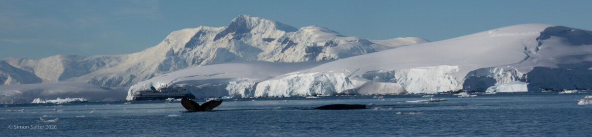
Heading back to the ship, I managed to photograph a dolphin. It was a grey river dolphin. Not as exotic as a pink dolphin but a dolphin nonetheless. A fine addition to my large collection of pictures of ripples on the river where a dolphin has just dived.
After lunch we moved back downriver so as to take the skiffs up the Zapote River (I think). Here there were many types of birds. Egrets were still in abundance along with kingfishers, wood peckers, parrots and toucans. Diane and the rest of the boat tried their hand at fishing. I wanted nothing to do with it. Fortunately, she did not catch anything. Something, probably piranhas, nibbled all the meat off her hook. Twice. Sometimes it is best to keep your hands out of the water while fishing.
Another 6am and we were up a creek without a name. Well, I am sure it has a name but it is not marked on my map so I have no idea. The creek was small, meandering and choked with weeds. We spotted a nose looking at us from a hole in a tree trunk. Probably a Nutria (coypu) a type of Amazonian rat. He watched us carefully as we drifted past but showed no sign of coming out. There was a brightly coloured tanager bird and then, at the base of the tree, some proboscis bats. This time we got close enough to see detail. Although only a couple of centimetres long, they are cute and furry. And they do have big noses. All bats are covered in fur, except for Batman. He wears a bat suit, to look bat like, but it has no fur.
We passed some kingfishers and a heron then someone spotted a monkey. Turned out to be a tamarin monkey although it looked to me like a stuffed cat hanging in the tree. There were some colourful aracari birds and sleeping sloth. The sloth was just a big ball of fur in the top of a tree. It never moved in all the time we watched it. At the end of the navigable part of the creek we saw some black-headed night monkeys. They were huddled together in a large tree hole. Each monkey was about the size of a squirrel. They peered out at us nervously. Amongst monkeys, these are the only truly nocturnal species. They are also particularly susceptible to malaria. Apparently, the presence of night monkeys is a good indicator that there is no malaria around. Still plenty of mosquitoes though and we had both applied a good layer of chemical warfare before we came out.
Capped heronBrown-mantled tamarinBlack-headed night monkeyChestnut-eared aracari
On the way back to the ship, we passed a fisherman who showed off the armoured catfish he had caught. These are not good eating. The locals occasionally make a soup. We saw some soup the following day and everyone thought it looked horribly unappetising. Quite possibly he threw it back into the river after we had passed.
VultureGrapefruitWasp’s nest
After the first shower of the day and breakfast we went out for a hike. This was in a cultivated area with many fruit trees, yucca and banana trees. Bananas are not really trees. They are in fact, herbs, and the fruit are berries. There were also grapefruit trees. Not so remarkable but I had never seen one before. The real reason we were here was a troop of Pygmy Marmosets. Tiniest of all monkeys and a native of the rainforests of the upper Amazon basin. They are remarkably cute but also very shy. They feed on the gum from trees. With sharp little teeth, they bite a hole in the bark. The gum pools in the hole from where they lap it up. After half an hour of trying to photograph the little blighters, I had a collection of pictures of part of a marmoset. The rest of the photograph being the tree, branch or leaves that it was hiding behind. We were not allowed to shake them out of the tree and pin them to the ground to get a good photograph – so this was going to have to do.
Early afternoon the ship moved quite a way upriver and in the evening, we went out in the skiffs to hunt caimans. The plural of caiman is not caimen. We drove out past a small settlement and were greeted by a small girl. She was showing off the piranha fish she had caught. These are not so dangerous as the films project. Unless you are bleeding, they are unlikely to attack. Even so, it is a special sort of young girl that handles one like a toy.
Pygmy marmoset
Into the small channel and the first things we saw were several types of monkeys. Again, photography was difficult. For a start there is not much light. It was early evening but even during the day, the thick canopy is remarkably effective at blocking the sun. The birds and animals tend to stay in the distance. Using a long lens, in low light from a small boat is not a good recipe for success. A while ago, I invested in a Canon 500mm f4 lens. This is a bit of a beast and heavy. An hour spent hoisting it around can get to feel like an upper body workout. Fortunately, it handles the conditions quite well. Even so, I often found that the light so low that I had to turn the camera sensitivity right up. This makes the images very grainy. Our guides were very good at identifying all creatures we saw but I could not remember all the names. I have resorted to Google so quite possibly some of the names of birds and animals are wrong.
BananaWhite-eared jacamar
Dark fell and our guide produced a powerful spotlight. Apparently, the way to hunt caimans is by looking for the light reflecting from their eyes. Like cat’s eyes, they appear to shine in the dark. Round a corner in a particularly weed clogged channel we came across several. Bright eyes on a small face lurking motionless in the water. We all looked at each other for a few minutes and the headed back to the ship for dinner.
The sun rose to find us bobbing around on the main river on our pre-breakfast skiff ride. Early in the morning is as cool as it gets and the mosquitoes are not too bad. Evening is the mosquito happy hour when you really need to cover up. Except in some places, deep in the forest which appear to be thick with mosquitoes any time of the day. Our morning ritual, before breakfast, now included mosquito repellent and sunscreen. Out on the river, the trick is to keep moving. Stay in one place too long and the little biters will arrive. Keep moving, every few minutes and everything is fine.
Cargo raftYellow-headed caracara
We met a raft drifting down the river. Three guys on a home-made construction of logs tied together. They were on their way to Iquitos. Tied at the front of the raft was a large net full of catfish that they had caught. A small motor on the back was to stop them drifting into a bank. After several days drifting down the river with their catch, they would be able to sell the fish and sell the wood they built the raft from. Then they would take their net and other possessions, head back upriver on the ferry, and start again. For now, they were sitting on the raft watching the world drift by.
Green iguanaBrown titi monkey
After breakfast, we were back in the skiffs and heading up a small creek. First thing we saw was an iguana. This was a green iguana, amazonian cousin to all the iguanas we saw in the Galapagos. Further on we spotted some tree houses. Apparently, these are available for rent. This looked wholesome fun. A room high in the treetops. For me, however, on balance, I’ll stick with the air-conditioned cabin. Next, we saw some brown titi monkeys. This is not what our guide called them. Unfortunately, I cannot recall what he said so I used Google. This is what Google calls them.
Great kiskadeeBrown-throated slothDusky-headed parakeetProboscis batWhite-eared jacamarAnteater
There was a group of Kiskadee nests hanging from a tree and a sloth doing some sort of slow, strange early morning sloth exercises. Our guide shouted to stop the boat and back up. There was an anteater. This surprised me on two counts. First, I never expected an anteater to be up a tree. Secondly, I could not see it. Eventually, I took several photos in the indicated direction and then zoomed into them on the camera screen. Sure enough, there was an anteater, up a tree, in a dark corner. It looked to be asleep. How our guide spotted it is beyond me. Amazing. On the way back we saw a classic green parakeet and some more proboscis bats. These look like so many little scabs on a tree trunk until you get really close to them.
Masked tityraVultureHawk
In the afternoon, we went to visit a village. First, we went to a pond with giant lily pads on it. Victoria Amazonica can grow leaves up 3 m in diameter. This impressed me and also brought back a memory. I had seen this sort of lily before. After pondering where I might have encountered a bit of Amazonian jungle previously, I recalled looking at giant lilies with my mother. This was many years ago at Chatsworth House, a historic stately home in the Peak District. The lilies date back to Victorian times when people cared little about invasive species but were very keen on impressing their nobility friends with the exotic plants they could grow.
Scarlet macaw
In the village came the inevitable presentation of craft goods which we looked at politely. We also looked at a partially built canoe, sugar cane press made from a tree trunk and some macaws. Very brightly coloured birds which, we were assured, were not pets but simply chose to hang out round the village. We also found an annatto tree. Locals use the bright red colour from the seeds of this tree to paint themselves so that they will look fierce. As well as a strong colour, the seeds also have a slightly nutty taste. This is why they are used, in the UK, as the colouring agent in Red Leicester cheese.
Up at dawn again for another short boat trip before breakfast. This time we visited the Pahuachiro Creek. The water here is very dark, a result of tannins from the vegetation along the bank. It is the start of the rainy season. This close to the equator it is hot and humid all the time. There are only really two seasons: wet and dry. At the peak of the wet season much of the forest is flooded. We could clearly see the high-water mark on the trees. A good two or three metres above the current level. This makes the jungle almost impenetrable. With a small canoe you can travel a short distance from the river course but it is slow and difficult.
The water in the main river is a chocolate brown colour because of all the silt it is carrying. Where the black water from the creek meets the main river the two types of water do not mix immediately but swirl around each other in intricate patterns. This is the place for the river dolphins. They hunt fish that have been confused in the merging currents. The dolphins use their echo location to hide in the murky, silt laden water and then dart out to catch the hapless fish. The Amazon River Dolphins are pink and have a bulbous head that is part of their echo location system. Slightly smaller are the Tucuxi dolphins which are grey and look a little like Bottlenose Dolphins. We saw both types but they are very hard to photograph. You need some sort of precognition to guess where they are going to pop up next.
Yellow-headed caracaraYellow-spotted river turtlePeruvian pinktoe tarantulaLonomia caterpillars
After breakfast, we went for a walk. Every time we walked in the jungle, we were warned not to casually touch things, not to lean on the trees and to be careful where we placed our hands and feet. This is seriously important advice. Shortly after setting off, we were shown a judgement tree. This is a tree that has become infested by fire ants. The trunk is riddled with holes and few ants can be seen running around. However, if you bang the tree then loads of ants come out. Traditionally, bad people would be stripped and tied to the tree. The village shaman would then hit the tree with a big stick. This “judgement” could be fatal. Shortly after pondering this lethal tree I came across a fuzzy blob on another tree trunk. This turned out to be a mass of caterpillars. What I didn’t realise at the time is that these can be equally fatal. The caterpillars of the Lonomia obliqua moth possess a uniquely potent anticoagulant venom. Wikipedia says “A typical envenomation incident involves a person unknowingly leaning against, placing their hand on, or rubbing their arm against a group of these caterpillars that are gathered on the trunk of a tree. The effects of a dose from multiple caterpillars can be dramatic and severe, including massive internal hemorrhaging, kidney failure, and hemolysis. The resulting medical syndrome is sometimes called lonomiasis. Death may result, either rapidly or after many days following envenomation”.
At the end of the walk, we spotted a sloth. In typically sloth fashion it was hanging from a tree looked like an abandoned bag of wet fur. Photographing sloths requires patience. They do not move very much and it sometimes hard to determine where the sloth ends and the tree begins. Eventually this one did move and not only did I managed to get a picture of its face but I could also spot that it was carrying a baby.
After lunch, while we were all snoozing, the boat moved further up the river. Here was a small village where we had been invited to see the release of some turtles. The yellow-spotted river turtle is one of the largest turtles and has been on the endangered list for a while. It has been hunted for food and was also exceedingly popular as a pet in the USA. Fortunately, now some work is being done to protect the turtles. The villagers collect turtle eggs and then protect them while they hatch. Once the baby turtles’ shells have hardened, they can be released into the wild with a much better chance of survival. We arrived at the riverbank by the village to find buckets full of baby turtles, all ready to be set free. Diane loved this. She carefully carried a bucket to a marked area by the water and tipped them out. The turtles knew exactly what to do and headed straight down the slope for the water. It was great to watch.
From Arequipa we flew back to Lima, yet again, for the New Year celebrations. The party was typically Peruvian and involved a massive and completely unorganised firework display on the clifftops of Miraflores. It was rather magnificent and chaotic. The park area was packed with people and colourful ordnance exploded all around us. Great fun. Two days later we flew to Iquitos to join an Amazon River trip. From the plane we could see the vast tracts of jungle with the river winding its way through it.
Bar on the Delfin IIThunderstorms most days
The Amazon basin is huge. Seven million square kilometres. The Amazon River is the largest in the world by discharge volume. It is also the longest, depending on how you measure these things. Near the head of the river, in north-east Peru, is the city of Iquitos, population 50,000. This is the world’s largest city that cannot be reached by road or rail. Average temperature 32°C with 80% humidity. Hot and sweaty. Not really my favourite environment but we wanted to experience a rainforest, or at least, I did, so we just had to put up with it. One of the selling points of the river boat we were joining was air-conditioned cabins. At least would have a cool refuge.
From Iquitos we were driven, on the only road, to the small town of Nauta, population 2,000. Nauta is located on the north bank of the Marañón River, a few miles from its confluence of the Río Ucayali. On maps, the point where the rivers join is the highest place that is named the Amazon River.
Delfin IIRed-capped cardinalHawkKiskadee
The river boat, called the Delfin II, operates several long, narrow, steel hulled boats that they call skiffs. Each of these has two rows of seats for a dozen people and two outboard engines on the back. The boats have to be quite tough because there is a lot of wood and other debris floating in the river. We were collected and taken to the Delfin which was holding station just offshore. Here we were introduced to our cabin. The accommodation was rather nice. A large picture window, good sized bed, nice bathroom and the all-important air-conditioning. It seemed like a significant part of the design of the river boat was to support the generators and heat exchangers necessary to run all the cooling systems. I was struck by the same contradiction that we experienced in Thailand. The general approach to dealing with global warming is to try and use less energy. But the way to deal with living in hot places is to use more energy so that you can keep cool. We had an excellent dinner and then went straight to bed with the warning that we were going to be up before sunrise the next day.
HoatzinRed-backed poison frogTarantula
The best time to explore the jungle is early in the morning. I had to reluctantly admit this. Neither of us are really morning people but the advantages are clear. It is a bit cooler but perhaps more importantly this is when most of the birds and animals are active. By lunchtime the rainforest is relatively quiet. Earlier it is buzzing with creatures all going about their business. So, up early, before breakfast and off in the skiffs. We saw many birds including Red-capped cardinal, Kiskadees and some hawks. We also saw a pair of Hoatzin birds. These are unusual amongst birds in that they only eat plants. To consume the vegetation, they have unique digestive system, which contains specialized bacteria in the front part of the gut. This ferments the food, mostly leaves, a process that produces a lot of ripe methane. Locally they are known as “stinkbirds” and are generally avoided by hunters. Apparently, they not only smell bad but also taste bad. Clever birds. Another clever aspect is that the chicks have claws on their wings. This allows them to climb around the tree where they nest. If attacked by predators such as great black hawks, the chicks will jump into the water and hide under the nest while the parents distract the attackers. Later, they can use their claws to clamber back into the nest.
After breakfast, we went for a walk. Walking in the rainforest is not entirely straightforward. We were equipped with Wellington boots, waterproofs and bottles of water. We also applied mosquito repellent and suns screen. It was hot and sweaty. Within a few minutes my shirt was soaked and after an hour my hands were going wrinkly as if I had been in a swimming pool. The forest was dense and reached high above us. So much so that there was not much light. Taking photographs was difficult. No just because of the low light but also because of condensation forming on the lens. We had a local guide who tended to wander off into the forest and then reappear with interesting things. First up was a red backed poison frog. These secrete poison through their skin to deter predators. The frogs are only small but the poison is nasty. Not necessarily fatal to humans but it will kill smaller mammals. Our man was careful to just hold the frog by its leg. Next up was a tarantula spider. Not sure exactly what type but it was enormous, for a spider. Maybe 12 cm long. Then we were shown a Boa constrictor which hissed at me and finally an Anaconda. This looks a little strange in the picture because it had just eaten something. After a couple of hours of walking we were more than happy to get back to our lovely cool cabin for a shower before lunch and an afternoon siesta.
Early evening, we were out again in the skiffs. This is the happy hour for mosquitoes, so we applied extra repellent. Even so, they munched on Diane quite a lot and she came up with many lumps and bumps. We saw Black-capped donacobius, several hawks and a few White-eared jacamar. There were bats on trees. These were a little hard to see. Proboscis bats are only small and blend into the tree bark. From any distance they look like leaves but get closer and you spot the details. Finally, there were monkeys. Squirrel monkeys. A big troop of them. Tricky to photograph because they are small, tend to stay far away and also like to stay hidden behind the leaves and branches. Terrific to watch as they leap around in the canopy. As dusk fell, we headed back to the Delfin II for another excellent dinner and another early night.
Our hotel, in Chivay, sits in roughly the centre of the Colca Valley. The valley goes SW about 80 km from Callalli to Huambo becoming increasingly deep and steep sided. Beyond there it becomes known as Colca Canyon. This section is one of the deepest chasms in the world with a depth of over 4,000 m. The gorge is not only spectacular but also home to many Condors. The Andean Condor is an endangered species although it is an integral part of Andean culture. The birds, with wingspans up to nearly 3 m can live to 70 years old. They can often be seen swooping up the down the canyon. A phenomenon that has become an important tourist attraction.
We took a steady drive down the lower part of the Colca Valley. Driving in Peru is interesting. There are no rules. At least, none that anyone appears to care about. Lane markers are completely ignored. Traffic lights are for guidance, at best. Priority at junctions is determined by forcing your way into the traffic. Any space between vehicles of more than half a metre is considered fair game to attempt to drive into. I have seen cars going the wrong way around roundabouts to gain an advantage. If a vehicle comes up behind you with flashing blue lights then it is probably just a vehicle with flashing blue lights. They seem very keen on this. Emergency vehicles use a siren as well, not that it appears to help them make progress. Indicators are often used, although their meaning is typically obscure. It is common to see a car indicating one way while turning another. Hazard lights are also regularly used. As best I can tell they suggest the driver is about to do something seriously unexpected like cutting across four lanes of traffic at right angles or stopping in the middle of a roundabout to onboard passengers. Pedestrians must be especially careful. One car accelerated, hard, to ensure they got to the middle of a pedestrian crossing before us. We were forced to make a rapid retreat. My best advice for walking around cities is to ignore any preconceptions you might have and just follow what the locals do. Stay in the middle of a group for safety.
Fortunately, the Colca Valley is not too busy. Once we were out of town, I could relax a little. Historically the area has been important for agriculture and livestock farming. Thousands of man-made terraces adorn the hillsides along with drainage channels and irrigation ditches. Ruins and remains dating back thousands of years have been found here. We stopped at various vantage points to take in the views. A significant amount of rural depopulation appears to be happening. Many deserted farm buildings and fields growing wild. After an hour or so we had made our way to the start of canyon proper.
We had a walk along the canyon edge. Quite aware of the altitude here, well over 3,500 m, so we took it steady. The views were remarkable. Mountains reaching up to 6,000 m and the chasm wall dropping vertiginously down to a river way, way below us. We came across some wild horses. I photographed some cacti. In a leisurely fashion, we wandered up to the Mirador Cruz del Cóndor, a series of observation platforms for watching the condors.
Microlophus
There were a lot of people here. Coach loads of tourists all hoping to see condors. Obviously, since there were crowds of visitors there were also many souvenir sellers. Large assortments of brightly coloured craftwork laid out on plastic sheets. One person was dressed in a rather large and impressive condor outfit. He hopped around on the wall and posed for photographs with the visitors. The only thing that was missing were the condors. There was not a hint. Scores of eyes were peering upwards, vainly searching the skies for the great birds.
Time passed. Lunchtime came and went. The tourists started to leave. The sellers began to pack up their wares. Eventually there were just a handful of people left and our guide was asking if maybe we should press on. I wanted to wait a little more and passed the time photographing some of the small birds that were fluttering around. I also photographed some tiny lizards and more cactus blooms. Wandering up and down I tried to find angles for a picture that would convey the enormity of the chasm and the vast drop below us. This proved to be remarkably difficult.
Rufous-collared sparrow
The wind began to pick up. It even became a bit chilly. Suddenly a condor appeared. Later we considered that maybe they needed the wind to be able to soar on the up currents. Big birds tend to avoid the effort of flapping their wings a lot, preferring to use air currents. Condors are the masters of this and in the right conditions will fly for hours with little apparent effort. Rising from way down the valley, the bird swooped up above us and glided into the distance. Then came another and another. In all we saw eight or nine birds majestically swooping around the viewpoint before slipping off into the distance. It was great. We had been patient and had our just rewards. I managed to get a few good photos.
Andean flicker
Feeling satisfied we drove back towards the shallower part of the valley. We checked out a church and walked down into a much smaller gorge to see some pre-Inca remains. In the distance loomed Ampato, an extinct stratovolcano which towers to 6,288 m in a classic volcano shape. Clouds forming over the cone looked ominous. As if the monster was coming back to life. Eventually we were back at the hotel. Las Casitas is based on little houses. Each hotel room, or casita, is actually a small house containing a bedroom and bathroom. The casitas are set in a large garden area with ponds, waterfalls, flower beds and lawns. It was all very tranquil and relaxing. Our room had an open fire in it which we were invited to light. This would have been lovely but, to us, the room was more than hot enough already. Wandering around the gardens, we came across a grazing alpaca that Diane talked to for a while.
This was the end of our Belmond trip. An indulgent dollop of luxury for my birthday and xmas. Also some interesting ways to travel. Next day we headed to Arequipa and the airport for a flight back to Lima. Lima again and this was still not the last time we would be there.
We were about to embark on a two-night train journey. I have always liked the idea of sleeper trains. Rushing through the night while tucked up in bed. Diane and I took a sleeper from Innsbruck to Hamburg a few years ago. It was great fun. Essentially for motorcyclists. You load your bike on the back of the train and then get in a little couchette. One bench seat and a small closet with a sink in it. Later, the guard comes round to turn the seat into bunk beds. We brought some food and a bottle of wine. In the morning the bunk went away and the guard appeared with coffee and croissant. At Hamburg we all disembarked. The train was turned around so that the bikes could be ridden off the back. Saves a two-day autobahn slog from Austria to Northern Germany.
This train in Peru however was a very different matter. Check-in was in the hotel bar and the first thing that happened was that, despite being only mid-morning, we were offered champagne and snacks. It would have been churlish to refuse, especially on boxing day. Our luggage was whisked away and a little later we were taken to the station. Onboard, in the first of two bars, we were introduced to the train and then taken to our compartment. Each car had two compartments containing beds, chairs and a bathroom with a shower. I have been in smaller hotel rooms. The whole train is an echo of a different, earlier age. A fantasy of sumptuous travel and attentive service. It felt like we had stepped back in time. Fortunately, on the practical side, everything worked and was spotlessly clean.
The train rattled off into the countryside. We had a pleasant lunch and then sat out in the rear car for a while. The back of this is open to the air. Ideal for photography and a fun place to watch Peru rolling past. It was not a fast train. There was plenty of time to watch the villages and fields of llamas. Mid afternoon we paused to look at some ruins. These were grain storage built by the Incas. Not the most fascinating but it was nice to stretch our legs.
As the afternoon went on, we climbed higher in the Andes. The scenery became more rugged and the settlements more sparse. Early evening we stopped at the train’s highest point. 4,430 m. There is a little station here and some locals selling craftwork. Back on the train we had an excellent dinner. I wore my new alpaca scarf in an attempt to look more stylish. The train rolled on towards Puno while, back in the privacy of our cabin, I indulged in one of the highlights of the trip, a shower in a moving train. Snug in bed we listened to the clacking of the wheels on the track as we fell asleep.
Get up at five in the morning and come to watch the sunrise over Lake Titicaca, they said. We did. I figured we could go back to bed and get another hour in before breakfast. It was dark when we got up. The train was parked on a pier right at the edge of the lake, so it was just a short walk to the water. At 3,800 m, Lake Titicaca is often called the world’s highest navigable lake. What they mean by this is that larger, commercial boats can sail on it. The sunrise was pretty good but more importantly, it felt like a special location. An hour later we did indeed head back to bed.
Much later, after breakfast, we headed out in boats to visit the floating islands. The islands are built by the Uros people although it is not completely clear why. Possibly to escape the Incas, or the Spanish, or other, more warlike tribes. Whatever, these days they are built to attract tourists. The islands are made of totora reeds which grow abundantly in the area. Although and island can last several decades it requires constant maintenance and replacement of the reeds that rot in the water. On the islands they build houses and reed boats. Each of the 120 or so islands is home to between two and six families.
When you arrive, they do a little dance, sing songs, show you inside the houses and try to sell you craftwork. Look closely and you can spot modern influences. Solar panels, electric lights, TV sets. Apparently, it is now possible to rent a straw room via Airbnb. We stood around politely with the rest of the group and were genuinely impressed with the reed boats. They seemed quite sturdy and stable.
Lake Titicaca has been shrinking over the past decade as successive droughts take their toll. At the same time, the increasing numbers of people living around the lake is causing problem with pollution, especially in the Puno area. We were warned about drinking the water or eating raw food.
Lunch was on the island of Taquile, population 2,000. When spoken, this sounded a lot like Tequilla, but sadly there was no connection. The men of Taquile are famous for knitting. In fact, it is how they prove their manhood. A well knitted item is essential when wooing a bride. It is only the men that knit usually starting at a very early age. The work produces a very tight knit item. We saw some hats that were probably waterproof so dense were the stiches. Also, bags, shawls, toys, socks, gloves and all manner of things. Women get to do the weaving.
We had a walk on the beach and got back to the little restaurant just in time for some more singing and dancing. Vegetarians are not really catered for so we ended up with some fried eggs and rice. Then it was the 45 km trip back to Puno where pretty much everyone fell asleep on the boat.
The train left late afternoon by rolling straight through the marketplace. This was quite a remarkable sight. Everybody stepped out of the way to allow the train to pass within inches. People seated at tables adjusted their seats. Stallholders pulled back the awnings of their stalls. Children and chickens hopped off the line. Then, as soon as the train has passed, they all crowded back again. The train passed through the massing throngs like a finger drawn across a plate of gravy. It would have been enough to give and Health and Safety officer a heart attack but nothing went wrong. Nobody got hurt. No produce got damaged. Before long we were in the suburbs and then out again into the countryside as night fell.
Andean Explorer – 22 cars long
Five o’clock next morning just three of us were up to watch the sunrise. Diane never even tried to get out of bed. Just told me to be quiet when I came back in. On balance, it was probably not worth the effort. I got a couple of interesting photos but the sky was overcast and we never actually saw the sun. It was interesting to see where the train had parked for the night. We were between two lakes with a handful of settlements dotted around. Here the people are mostly busy with managing shellfish in small, netted off areas. As the pre-dawn light began to lift the darkness I could watch them coming out in small boats to check their nets.
Later, after an excellent breakfast, the train was pushing on into the Andes and we could see volcanoes looming in the distance. A few llamas dotted the landscape and also some vicuña, wild mountain brothers to the llama. Just after crossing an excellent bridge of rivetted ironwork, we stopped to visit some cave paintings. This involved a short trek down into a gorge. A local guide unlocked a steel fence and proudly presented the paintings. Apparently, these are six thousand years old. Cynically, they looked to me like something some kids might have scratched on the wall one weekend when they were a bit bored. This is probably why I have never aspired to being an archaeologist.
Back on the train we travelled for another hour or so across the increasingly desolate landscape before arriving at the km 97 marker. Here we were told to get off. Not everyone, just me, Diane and a handful of others. The rest of the train would arrive in Arequipa by early evening. We, however, were off to another Belmond hotel. Las Casitas hotel is set in a little oasis to the south of Chivay. In the meantime, we had been dropped off in the middle of nowhere. A single building in the otherwise barren semi-desert of the altiplano. Fortunately, the sense of abandonment did not last long. Cars and minibuses arrived to collect us. Twenty minutes of dirt track took us to a tarmac road and then on to Chivay.
On the way we passed through a national park area and saw many vicuña. Also a few ponds with some sort of black duck. The road rose over a pass at 4,900 m. This is Diane’s altitude record. We stopped at the viewpoint from where you can see multiple volcanoes. This is also the site of Peru’s highest toilet, a magnificent stone built building where, for a modest fee, you can also wash your hands out of a bucket. From here came the long descent to Chivay and our hotel. Beyond that lay the formidable Colca Canyon.
Next day we visited Machu Picchu for the second time. This was so different, and so much better, than the first trip. Two days later, we really felt like we had explored Machu Picchu whereas previously we had just rushed through. For a start, we did not need to get up at silly o’clock and listen to a monotonal monologue that drilled into my skull while being bounced along in an uncomfortable minibus. No. This time we had a leisurely breakfast before a short drive to the train station at Ollantaytambo. Here we boarded the train, but not the crowded tourist train with water and a dry bread roll. Today we were on the Hiram Bingham. This is the name of the guy who discovered Machu Picchu (sort of), it is also the name of a Belmond train that runs once per day. We were welcomed on board by a three-piece band. The coaches were spacious and comfortable. Then we got served an excellent lunch as the train slowly rattled down the valley. Living the life.
Minibus to the ruins
At Agues Caliente, the Machu Picchu train station, we were ushered into the same sort of minibus as before. There are only a limited number of vehicles that can use the dirt road. Thirty minutes later we were at the same entrance as before but now we were fresh, comfortable, not struggling with the altitude and we had a guide with a sense of humour.
Entrance
Obviously, the ruins were just the same ruins as before. We were feeling good and the weather was better. So much better was this that I actually paid attention to what the guide was saying. I was also in a much better mood to get some proper photographs.. The joints in the Inca stonework was far more interesting as was the solar calendar. I enjoyed photographing the window where Hiram Bingham had erased Agustín Lizárraga’s note of 1902. I even photographed a few flowers. In summary, the day was delightful.
Since our previous visit we had been doing some homework. In particular, watching films that feature Machu Picchu. The earliest, Secret of the Incas, 1954, staring Charlton Heston is a classic and the basis for Indian Jones. Much later came Transformers, Rise of the Beasts. I spotted the field that Monkey landed on and the terraces that the ensuing fight destroyed. We skipped Dora and the Lost City of Gold but may yet watch The Emperors New Groove. With great anticipation we are awaiting the release of Paddington in Peru.
Agustín Lizárraga’s note was here
Tour finished; we went to our hotel. Not all the way back down into valley, but to the Sanctuary Lodge, another Belmond hotel, right next to the entrance to the ruins. We watched the sun set behind the mountains and listened to a Peruvian ensemble playing some traditional music. Most tourist sites, coaches, bars and so on play a background loop based on El Cóndor Pasa. Originally this was an orchestral musical piece from the zarzuela El Cóndor Pasa by the Peruvian composer Daniel Alomía Robles , written in 1913 and based on traditional Andean music, specifically the folk music of Peru. Since then, it is estimated that over 4,000 versions of the tune have been produced worldwide, along with 300 sets of lyrics. In 2004, Peru declared this song as part of its national cultural heritage. It is now considered the second national anthem. Diane was convinced that the song originated with Simon & Garfunkel from their best-selling album, Bridge over Troubled Water, 1970. Their version, with their own lyrics is called El Cóndor Pasa (If I Could). Google was the eventual arbiter in resolving this disagreement.
Huayna Picchu
In the morning, we were up early for a walk. 7am we started the long plod up Machu Picchu. The ruins, usually called Machu Picchu are actually set in a saddle between two mountains: Machu Picchu and Huayna Picchu. The latter is the mountain with steep looking steps and terraces near the top. It often appears as a backdrop to the ruins. Machu Picchu is the less photogenic but higher mountain behind the ruins. 650 m of steep steps take you to the summit. We got a little over halfway up but were happy with this and enjoyed the views. On the way back down we got to visit a previously unseen part of the ruins which was fun.
Agues Caliente
Eventually we ended up back at the Sanctury hotel where we had a lazy afternoon. Sitting at the restaurant table I could look, through an open window, at a birdfeeder for Hummingbirds. It was red and contained sugar water. I spent a very happy hour, with a glass of wine, photographing the birds that arrived.
Late afternoon, we headed back down the hill to meet up with the Hiram Bingham again. On the way back the train stops at Ollantaytambo but then continues almost to Cuzco. A three and a half hour trip. It was xmas eve so our table was set out with a little nativity scene. I liked that the brown baby Jesus was represented as a small corn cob wearing a chullo, an Andean style of hat with earflaps. Joseph, another cob, was similarly adorned. We set the scene up on the windowsill where the donkeys could look over us as we ate. Terrific meal and then we wandered up to the bar. Here a band were playing and bit of a party was going on. Great was to spend xmas eve.
We got back quite late. The hotel staff suggested we go down to the town square to watch the fireworks at midnight. I assumed some sort of organised display. But this is Peru. Everyone brought their own fireworks down and then simply let them off where they stood. It was a glorious chaos. Fireworks exploding left, right and centre. You needed to keep your wits about you as jumping jacks bounced through the crowds and the occasional badly launched rocket shot along the cobbles.
Next day, in the afternoon, we had another short tour of Cuzco. In particular, we were taken up to an Inca fortress above the city. Here we could marvel, again, at the incredible Inca stonework. We also got some great views of the city on the way back down. In the evening we packed ready to join another train the next day.
We flew back to Lima. Again. This would be out third visit to Lima but not our last. We were joining a trip organised by Belmond. They are a global travel and leisure company. Our interest was that they operate several hotels and trains in Peru. Our trip, which would cover my birthday and xmas, was going to involve a couple of trains, Machu Picchu (again) and a few hotels. It began at the rather lovely Miraflores Park hotel in Lima. I was particularly impressed by the pond full of turtles just outside the front door. Here we also reacquainted ourselves with Paddington at sunset.
Next day, my birthday, began with a city tour. First stop was a museum. I have mentioned several times before that we are not really museum people. The idea of celebrating reaching 64 in a museum is not one I would have chosen. In the event, the tour actually proved to be quite interesting. We learnt about the Cusco school of art that developed during the colonial period and is characterised by religious paintings that incorporate Inca themes. The Cuzqueña painting style freely mixed traditional Inca colours, llamas, depictions of Pachamama (Inca earth goddess) with baroque style images. To me this feels like a subversive cultural revolution hidden in plain sight from the European Catholics. My favourite painting, The Last Supper, 1753, by Marcos Zapata, depicts the usual last supper stuff but with a guinea pig centre stage on the table. Jesus eats guinea pigs – I have proof. To my delight, we later saw the original painting in Cuzco Cathedral. The tour ended with an unexpected glass of sparkling wine in a richly decorated side room. On balance, as museum tours go, not so bad.
Jesus eats guinea pigs
After that came a walk around the historic centre of Lima and the main square. There are some fabulous buildings and churches here. The weather was nice. The trip did not take too long and the day ended with an excellent pizza not far from the hotel. Next morning we flew to Cuzco.
Cuzco
This time we were getting a bit more used to it. Not only had we started to acclimatise to the altitude a little but also the day did not involve a silly early start. We left Cuzco immediately and were taken off on a small tour that began in a textile museum. This was a place we knew from the Hx trip, so we skipped past the main display and went straight to visit the llamas. Next, we were driven in the direction of Pisac and the Sacred Valley past an interesting hotel at Pachar. The accommodation here is a series of pods slung high on a cliff. After climbing a sheer wall for a couple of hundred metres you can sleep cosy in a pod with, presumably, excellent views along the valley.
Pisac is an ancient Inca town with narrow streets and amazing stonework. We wandered round some of the ruins and took in a few of the tourist attractions including tuk-tuk taxis, many colourful shops and the Incabucks coffee bar. Clambering up onto the remains of an old fortification we were reminded of the altitude here. It was well worth the effort for the view down the valley.
Path to the cliff pods
Next stop was higher up the side of the valley, 3,500 m, at an archaeological site called Moray. Here there are Inca remains, predominantly, several terraced circular depressions, the largest of which is 30 m deep. The depth, design, and orientation with respect to wind and sun creates temperature difference of as much as 5 °C between the top and the bottom. This has led archaeologists to speculate (guess) that the different terraces were used to study the effects of climate on species of plant. By growing potatoes, for example, they could determine which conditions favoured each of the 3,000 potatoes varieties that are cultivated in Puru.
Penultimate stop of the day was the Maras Salt Mines. Here, naturally occurring saline water from a deep spring is led into evaporation pools. The pools are built like a series of terraces on the hillside. A system of small dams control how the water is fed into each pool. Once a pool is full it simply sits in the sunshine, evaporating, until eventually the salt can be scraped off. Archaeological research suggests that the salt mines were used over a thousand years ago.
Finally, we arrived at our hotel for the night. The Rio Sagrado hotel by the Urubamba River in the heart of the Sacred Valley. This hotel is built of a series of detached small houses set in a beautifully manicured garden. We got to end the day drinking white wine while watching the humming birds flitting around the bushes.
From Galapagos we flew to Guayaquil. We could have stayed on the plane all the way to Quito, but first stop was Guayaquil, so we got off to have a look. Possibly the main thing we learned about Guayaquil, is that we would not want to go back there again. The place feels strangely dangerous. As we got out of our taxi, I spotted armed guards either side of the hotel entrance. Later, as we walked into town, we saw that all the larger shops, pharmacies, banks and offices also had armed guards. Smaller shops used solid steel shutters, barred windows and barbed wire. It had just gone dark when we were wandering back and we heard a gunshot. I am no expert on this, but I could not think what else would have made the sound. By then, the streets were virtually deserted although it was only early evening. We walked in different directions from the hotel and found the same story everywhere. That was enough for us. Nothing bad happened, we were not assaulted or accosted, we did not see anything happen. Even so, we were happy to push on to Quito.
Quito
In Quito, we stayed at a delightful old hotel at the edge of the old part of the city. Quito’s historic centre is among the largest and best-preserved in the Americas. In 1978 it was one of the first World Cultural Heritage Sites declared by UNESCO. We spent a couple of days happily wandering around here. Narrow streets, old buildings, small park areas, public squares and many old churches. There were also a few museums which we skipped and no end of tourist-orientated shops. We also found some terrific places to eat. First of these was a vegetarian Italian restaurant. We arrived at dusk and were shown to a table in a small open courtyard inside the building. Very atmospheric. Especially when the candles were brought out. Electricity in Quito appears to be a bit of a problem. There is electricity but not everywhere and not all the time. A strong dependence on hydroelectric power is currently a problem because of the severe drought. For several years the rainfall has been dangerously low. This combined with poor maintenance of the power stations and a general lack of capacity has caused a program of rolling blackouts lasting up to 14 hours. Some shops use generators. Typically, these are running on the pavement outside and this makes for a very noisy city. Our restaurant used candles which was really quite lovely.
In the central square, we found a hat shop. Panama hats. As you know, Panama hats come from Ecuador where they are also known as Jipijapa hats or toquilla straw hats. There are several stories about why they are called Panama hats. Possibly because they were popular amongst workers on the Panama canal. In 1906, U.S. President Theodore Roosevelt visited the construction site and was photographed wearing a Panama hat. Perhaps my favourite story is that Panama hats were introduced at the World’s Fair in Paris 1855. Ecuador was out of favour with France at the time and so they were marketed as from Panama. The quality of a hat is essentially determined by the number of fibres per inch. A good one will have more than 300. The absolute best, known as Montecristis, after the town of Montecristi, Ecuador, can have up to 3,000 fibres per inch. This particular hat shop specialised in the more up market model. They started at $500 (USD) each and went up to a rather eye watering $21,000. We didn’t buy one despite being subjected to a good 20 minutes of high-powered sales pitch. A little further down the road we found a shop specialising in stuffed Capybara. We did not buy one of those either but they were rather cute.
There is a cable car in Quito. This will take you up to a fantastic viewpoint at 4,100m. We arrived there more breathless than ever. The views were well worth the effort. We took a slow walk along a ridge to a slightly higher vantage point. Along the way Diane found some swings. We also paused to be photographed with some llamas. Obviously, we needed to borrow hats and ponchos for this.
Our last evening in Quito there were fireworks. We never found out why but we were still quite happy to watch them from the rooftop terrace of our hotel. I also managed to get a photograph of the magnificent Basílica del Voto Nacional. This splendid gothic church is illuminated at night. Looks terrific but I did wonder if the Catholics were getting more than their fair share of electricity.
Genovesa Island is a shield volcano in the east of Galapagos. Part of the wall of the main caldera has collapsed so that it is now possible to sail into the caldera. There are very few caldera like this. By an odd coincidence, one of the others is at Deception Island off the Antarctic peninsula. We had been there at the beginning of November. The only other navigable caldera in the world, that I know of, is Santorini in Greece.
Yellow-crowned night heronSwallow-tailed gullLava heronTropicbird diving into its nesting holeFrigate bird
What makes Genovesa unique is the concentration of birdlife there. Frigatebirds, red-footed boobies, Nazca boobies, swallow-tailed gulls, storm petrels, tropicbirds, Darwin’s finches, and Galápagos mockingbirds. Thousands of them. Great clouds of birds in the air and the ground seems to be covered in birds either resting or nesting.
Galápagos Brown PelicanRed-billed tropic bird
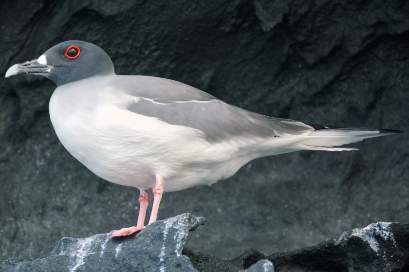
Access is very tightly controlled here. Especially since a recent outbreak of bird flu. Only a few people are allowed to land at any one time and you are only allowed a short time, two hours I think, ashore. We started off with a RHIB cruise along the cliff edges of the caldera. There are no historical records of volcanic activity at Genovesa but the are some young lava flows. The cliffs were full of nesting birds. In enjoyed watching the rather exotic looking, red-billed tropicbirds popping in and out of holes in the rock. There were also herons, pelicans and a few sea lions.
Blue footed boobyGalapagos doveFinchRed footed boobies
To get onto the island, there is a very steep wooden staircase running up inside a crack of the caldera wall. It is not dangerous, but definitely an interesting way of getting onto the island. I spent a while at the top of the steps photographing the tropicbirds. These are normally solitary creatures but I think it must be that time of year when they stop being solitary for a while. Pairs and small groups were creating a terrific display swooping around in formation.
The steps led to a rocky plateau with many bushes and more birds than I have ever seen in one place. Great flocks of terns were flying along the shore interspersed with a few larger birds. The bushes seemed to be full of birds. Mostly boobies. Red and blue footed plus a few Nazca boobies. Some of them were nesting and we spotted a few chicks and youngsters.
Nazca booby
In carefully shepherded small groups we walked across the plateau towards the far shore. We could not get anywhere close to where the terns were fishing. A short walk parallel to the shore and then back to the steps via a slightly different route. Everywhere there were birds and more birds. In the air, on the floor, in bushes and sat on rocks. None of them seemed especially nervous of humans although we were under strict instructions not to approach them. In places they were sat on the marked track so we had to carefully step around them.
Back at the steps, we clambered into the RHIB and were taken to a small beach area. We could walk around a little here. People were also allowed to snorkel and swim if they had the inclination. We stayed out of the water but did explore inland a little. More boobies, herons and sea lions.
I took an awful lot of photographs. Possibly my personal record for number of pictures in one day. Less than a thousand, but not by much. They are not all here. What you get here is the result of several hours inspecting and deleting. Then comes cropping and occasionally a bit of colour manipulation. Mostly I just stick to changing the exposure on some or all of the image. Back in the days of celluloid film we used to do this using carboard shapes on a stick to mask part of the final print while it was being exposed under the enlarger. A technique called dodging and burning. These days it is just messing on the computer.
Galápagos mockingbird
This was the last day of our Galapagos trip. Quite a spectacular day to end with. Overall, the trip has been terrific. The Galapagos is a fascinating place with a completely unique population of flora and fauna. The Hx vessel, the Santa Cruz II, was nice as well. Life there was a little regimented but the crew were friendly and the food was excellent. Next morning we were up early for the flight to Guayaquil.
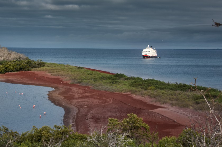
Rabida has an unusual red beach. The lava that originally built the island was rich in iron. This oxidises to form rust as it is being ground into sand by the sea and hence a rusty red beach. While not unique it is one of only a handful worldwide. Rabida also has flamingos. They are pink. Nothing to do with the rust but because they metabolise the carotenoids found in the algae and brine shrimp. Carotenoids are a natural pigment found in many plants. They make carrots, and occasionally my baby sister, orange. They also make tomatoes red and salmon pink. We had seen some pink flamingos earlier but I had yet to get any worthwhile photographs of them. I was on a bit of a mission. The beach traps a small brackish lake which is where the flamingos hang out munching on the shrimp. They took almost no notice of me at all so the photographs were easy.
White-cheeked pintail
There is a nice little circular walk on the island. Takes you up on top of some cliffs overlooking the beach. Past many prickly pear cactus plants. I tried eating a prickly pear once. Many years ago, when I was still young and daft. Carefully peeled the skin off with a knife while wearing a pair of gloves. Still ended up with my tongue covered in prickles. Nasty short thin prickles that break off in your skin and then stick out a tiny amount. Really, really annoying for days. Given them a wide berth ever since.
Galapagos mockingbirdGalápagos dove
There are nine different species of Darwin’s finches on Rabida. I saw a few but only managed to photograph one. We also saw a mockingbird, a dove, a pelican and handful of young ducks on the pond that google claims to be white-cheeked pintail.
In afternoon we visited Bartolomé Island. This is one of the younger islands in the archipelago and its volcanic heritage is very clear. A wooden walkway has been built up to the summit where there are some excellent views. First problem was getting past the fur seal on the path. I tried a hard stare, Padding Bear style, and that seemed to help. The path makes crossing the rough lava much easier. It leads you past a couple of smaller cones before turning up towards the top of the main cone. Diane counted exactly how many steps there were to the top. She likes doing things like that. Sadly, she has now forgotten how many steps there were – but it was quite a few. On the way back down, I watched several blue footed boobies fishing. They would typically start their dive from 30 m up. How they can spot a fish from up there is beyond me. The dive was always an all-in, total commitment thing so they hit the water like little missiles.
We got back into the RHIB and had a short cruise. There were rumours of a Galapagos penguin colony but we just found an individual bird. Plenty of fur seals though.
Post Office Bay on the north side of Floreana Island hosts an unusual post office. There is no building, no workers and no stamps. Instead, there is a barrel on a post. None the less this is a real post office and post does get delivered worldwide. The post office was set up at the end of the 18th century by whalers who often spent years away from home. The principle is that anyone can leave post there and no stamp is required. But you also need to check through all the other post that has been left in case you can deliver it. If for example, your ship was soon to head back to London then you would take mail addressed to London with you. Often the mail would finally be hand delivered. It was a slow system. Might take years. But it worked and it still works now. We left a few cards that may turn up one day. Some of the other travellers that were heading home soon took cards with them.
The post boxPost office bayGalapagos flycatcherView through the glass bottom boat
In the afternoon we went out on a glass bottomed boat. Really, if you want to look at the sub-sea life, you should dive or snorkel. Diane has never done snorkelling and was not too keen on learning on her own. My legs were not up swimming. So, we took to the glass bottomed boat. It seems like a promising idea. Unfortunately, all I can really report is that it is better than nothing. You can see a little of what is going on in the ocean. But not very much. I soon got a sore neck. In fact, I ended up spending more time looking at the birds around us than the fish underneath.
Swallow-tailed gull
Next day, we were much further south. Like most of the Galapagos islands, Santiago Island also has many other names. These include James Island, San Marcos Island and Duke of York Island. Our first visit was a RHIB cruise in a bay at the north of the island. When we arrived, there was another tour boat there. This happened quite a few times. The tour operators work hard to try and stay apart so usually you get to feel like you have the place to yourself. We got close to a pelican that was fishing. It used the big sack of skin under its beak like a net. There were blue footed boobies dotted along the shore. They mostly just looked as us in that slightly enigmatic way. We also saw quite a lot of swallow-tailed gulls. Some of these appeared to be pairing up.
Brown noddyEurasian whimbrel
We were settling into life on board the Santa Cruz II. Up in the morning for breakfast of fresh fruit, nuts and yoghurt. One of the cooks made omelettes to order which I really liked. Then off for a landing of some sort. The weather was the same every day. Warm but not too hot. Cloudy with sunny intervals. Occasional rain. Light clothes and a raincoat were all we ever needed. Lunch was a buffet of salads with a few hot dishes. I tried to stick to the salads but often there would be something very tasty looking that would lead me astray. At lunch we got to choose what we wanted for dinner. The menu was generally very good. I often had pasta but there were usually some other interesting dishes. Then came the afternoon landing after which I would retire to the cabin to take all the photographs off my cameras. Sometimes I would have time to process a handful that we could show to some of the other guests. Pre-dinner drinks on the back deck. If we were lucky this would include the sunset. Each evening there was a presentation at the bar about what was going to happen the next day. Then came the evening meal which would often end with us chatting for a while with whoever we shared a table. Early to bed ready to repeat the next day.
Lava heronYellow warbler
In the afternoon we had a wet landing at a beach to the west. Wet landing means that you will get your feet wet. Some people have shoes that are fine in the water. We tended to land in bare feet and then put shoes on once we were ashore. The shoreline was packed with marine iguanas and fur seals (sea lions). As usual, there were brightly coloured sally lightfoot crabs running around and I also spotted some sort of curlew. Google claims it to be a eurasian whimbrela, but I really have no idea. The big excitement of the afternoon was a pod of Orca swimming past. I managed to get a photograph of one of them. On the way back to the RHIB, I spotted another land iguana.
Darwin’s finches (also known as the Galápagos finches) are a group of about 18 species of passerine birds. I just learnt the word passerine. It sounds impressive but just means that they perch. This includes nearly half of all bird species. The thing about the finches is that Darwin noticed there were distinct species on different islands. In particular, there was a lot of variation in beak size. This is a classic example of adaptive radiation, which is the rapid evolutionary diversification of a species that occurs when its members occupy different habitats. The birds are thought to have evolved from a single finch species that came to the islands more than a million years ago. I tried to photograph a few of them.
Santa Cruz Island hosts the largest settlement in the Galapagos archipelago. Puerto Ayora, population 18,000. We spent the whole day on the island visiting various sites. First of these was the Charles Darwin Research Station. This is an interesting place that principally conducts scientific research and environmental education for conservation. The Station has a team of over a hundred scientists, educators, volunteers, research students, and support staff from all over the world. We skipped past much of this stuff and were taken straight to the tortoise sanctuary.
Finch
In the sanctuary, in fenced off areas, were baby tortoises, adolescent tortoises and great big tortoises. They can live to be well over 100 years old and weigh over 400 kg. They are the largest terrestrial cold-blooded animal. Like the finches, they have diversified across the islands. Darwin’s observation of the differences was another contribution to the development of his theories. The tortoise nearly went extinct in the 20th century as a combination of habitat clearance and exploitation. In particular, they were very useful on the ships of old. Before refrigeration it was difficult to keep food fresh on long voyages. Live animals were often taken but these still had the problem that they needed to be fed and watered. A tortoise, however, can survive for up to a year on its stored fat. The sailors of old would collect a rack of giant tortoises. They were not difficult to catch. Then each week they could crack open another tortoise for fresh meat. From an estimated 250,000 in the 16th century, they were down to 15,000 in the 1970s. Elsewhere, giant tortoises, that were common in prehistoric times, have all gone extinct.
Sugar cane pressBoiling down molasses
These days, the tortoises are doing much better. The introduction of goats was particularly bad for the tortoises because the goats ate all the vegetation. There are now very few goats in Galapagos but this did require some rather drastic action including the use of helicopters to hunt and shoot them. On Isabella island this accounted for some 150,000 goats by 2006.
A tortoise was spotted on Pinta island in 1971 that turned out to be the last remaining individual of a subspecies. They called him Lonesome George. For decades he was known as the rarest creature in the world. George serves as an important symbol for conservation efforts in the Galápagos Islands and throughout the world. He was relocated the sanctuary and a worldwide search was put in place to find him a mate. It never worked and in 2012 he died of natural causes. He was frozen, shipped to the USA, stuffed and, eventually, sent back again. We were shown the result of the taxidermy in a special room at the sanctuary. It is a big stuffed tortoise. I was not impressed but then I have always found taxidermy a bit revolting.
Cocoa podsStill
Sanctuary done, we went to a sugar cane farm. In quick succession we were shown how to press sugar cane. How to boil the resulting liquid down to molasses. How to ferment the molasses and how to make moonshine in a homemade still. This was all fairly interesting but the highlight was to try some of their hooch. The farm also grew cocoa beans. I spotted some pods growing on trees which is the first time I had actually seen cocoa pods growing. We also spotted an owl in the roof above the still. He seemed to be quite content keeping an eye on proceedings.
Final event of the day was the wild tortoises. Galápagos tortoises occur in different subspecies on the several of the Galapagos islands. We went to see an area where the Santa Cruz tortoises run around. Apparently they were all coming up from the coast because it was the mating season. When I say “run around”, it is kind of a relative term. Some of the tortoises did move but it would appear that you do not get to live to 177 by rushing around. Most of the day they eat grass. In the morning, they will stand up and move about half a metre forward. Then, after settling down again, they eat all the grass they can reach with their long necks in a semi-circle in front of them. After a short rest, they stand up and the process is repeated. Watching wild tortoises is interesting rather than exciting.
Giant stepping stones – I was temptedA yellow warbler for scaleTortoises charging through the forestPuerto Ayora
At the north side of Isla Fernandina is Espinoza Point. This is where we found ourselves the next day. Landing sites in Galapagos are limited. You cannot just rock up anywhere you want and go ashore. You need a permit. You need to follow the rules. You need an official guide and you need to be off before 6pm. This is one of many reasons why, if you want to see the Galapagos, you need to sign up for an official tour. You will see the same things that everyone else does. You will visit the same places and be herded around in the same way. I think groups are coordinated so that only a few people get to visit each location at a time. Even so, if often did not feel at all like exploration but more like a park visit.
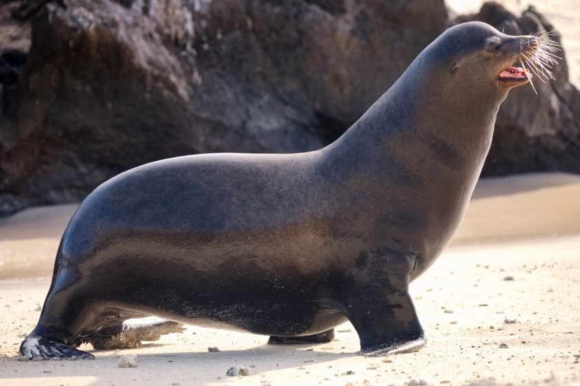
Fernandina is the youngest of the islands and last erupted in 2005. Our landing point was a narrow stretch of land famous for the hundreds of marine iguanas that hang out on the black lava rocks. There were a remarkable number of iguanas there. Ugly lizards that rarely seem to move. To help deal with the sea water they secrete concentrated salter water through their heads, so they often appear to have white heads. We also saw some flightless cormorants. Another species endemic to the Galapagos and the only species of cormorant to have become flightless. In the water were some sea lions. Or possibly Galapagos fur seals. By the time we left I had yet to work out the difference. The fur seals are not like the Antarctic fur seals but are actually a type of sea lion – which to me looked just like the other sea lions. Whatever, there were many young sea lions around playing in the water and generally being very cute.
We cut across a relatively young lava flow which was interesting for the cactus that had grown on it. In Iceland, a relatively new lava flow is indicated by grasses that are the first plants to take hold. Here, in a much warmer climate, it is a specialised type of cactus. There were a few blue footed boobies and brown pelicans. I also spotted a single yellow warbler in a bush. We also got shown the back bone of a whale that someone had carefully laid out on the rock. Not really sure what this was about.
This turned out to be a typical day in the Galapagos. Sail somewhere new. Go ashore. Look at animals. Back on board by 6pm. It was relaxing and fun. Also, in contrast to the other Hurtigruten vessels we had been on, the food was great. Proper tasty vegetarian food. Made us feel very happy.
An early morning start for the flight to Galapagos. The plane went via Guayaquil and we arrived at the Galapagos just after lunch. Short ride in a bus and then onto a RHIB to take us to our home for the next few days, the MS Santa Cruz II. This is one of the smaller vessels in the Hurtigruten fleet. A maximum of 90 passengers. Our cabin was small but comfortable. First thing I did was to flop onto the bed and think about having an afternoon nap. No chance. As soon as the new passengers were on board, the ship up anchored and sailed up to Punte Vincente at the north of Isla Isabella. As soon as we had finished lunch, the obligatory introduction to the ship and safety procedures we were off on a RHIB cruise.
Marine IguanaHawaiian stiltMS Santa Cruz IIGalapagos land iguana
The Galapagos is an archipelago of volcanic islands about 1,000 km off the coast of Ecuador. The islands are famous for their large number of endemic species. These were studied by Charles Darwin in the 1830s and inspired his theory of evolution. Ecuador won its independence from Spain in 1822 and formally claimed the islands ten years later. This was essentially unchallenged because nobody else really had any interest in the islands where it was reported that there were just some ugly animals. Today, Galapagos is primarily a tourist spot with about 300,000 visitors a year. Tourism is heavily controlled so as to preserve the ecology. Independent travel is difficult. Most tourists will join organised tours that are usually based on a ship. There are only 116 visitor sites in the Galápagos: 54 land sites and 62 scuba-diving or snorkeling sites. Small groups are allowed to visit in 2- to 4-hour shifts only, to limit impact on the area. All groups are accompanied by licensed guides.
Blue footed boobyNazca boobyYoung fur sealGalápagos Brown PelicanMarine iguana
The short cruise was followed by a landing and a walk. On the cruise we saw a remarkable variety of animals and birds. Now we saw even more including pink flamingos and several other birds that I completely failed to photograph. First thing I noticed as we approached the coast were the marine iguanas. Hundreds of them hanging out on the rocks with some very colourful crabs. The iguanas are cold blooded so they like to sit in the sunshine to keep themselves warm. Onshore we found a land iguana. Big brother to the marine type. He was easily a metre long. There are a lot of birds. Possibly most famous are the boobies. Blue footed boobies look faintly ridiculous especially when they do their mating dance. The routine is essentially about showing off their feet. We also saw a couple of Nazca boobies with their chicks. There was a solitary Galapagos penguin. This seemed very odd to me. It was clearly a penguin not too different from the Humbolt penguins we saw on the way to Antarctic. But this was the equator. What is a penguin doing here? I felt like telling it to go south back to the ice and snow. In fact, they live quite happily here. They are the only equatorial penguins and the only ones to ever be in the northern hemisphere. The equator passes through Galapagos so occasionally these little birds can wander, briefly, into the north.
Up at 4am for a quick breakfast before jumping into a minibus. The breakfast spread was very impressive. Sadly, at such an early hour of the day, my stomach had almost no interest in food. At 3,400 m the effects of altitude are not too severe. Some people might get a headache. Most people will feel a bit breathless and tired. I have been at altitude many times and always found the best way to deal with it was to get plenty of sleep. Hurtigruten had other ideas and we were finding the schedule brutal. Judging from the look of everyone else in the minibus, so were a few other people. The trip to the train station at Ollantaytambo station was almost two hours. Our guide talked without a break for the whole trip.
We queued a while for the train and were then guided to our allocated seats. The train journey to Aguas Calientes was considerably more pleasant than the minibus. Relatively smooth and with some increasingly interesting scenery. We were served coffee and a bread roll. The servers, two of them, then put on national costumes and did a play. I think that is what it was. We were sat at the end of the carriage looking the wrong way. I was mostly aware of them running up and down the gangway behind me.
At Aguas Calientes we were led out of the train station, across the road, and put into another queue for another minibus. The road up to Machu Picchu is a steep track with 14 switchbacks. It is steep, up to 27%, narrow and challenging especially in the rain. The road is listed at dangerousroads.org. It was raining but we made it to the top and the small carpark where a sign announced that we had finally arrived at Machu Picchu.
The Lost City of the Incas is considered one of the wonders of the world. A mountain citadel built in the 15th century on a mountain ridge at 2,400 m in the Eastern Cordillera of southern Peru. There is some uncertainty about why Machu Picchu was built. The Incas had no written language so records are sparse. The site was abandoned in the 16th century, possibly because everyone died of smallpox brought by travellers. It remained unvisited by Europeans until the 19th century. Currently the leading theory is that Machu Picchu was a private city for Incan royalty. A holiday home on a grand scale. Back in the day, there would have been up to 750 people here working the land and supporting royal activities.
Hiram Bingham, a Yale lecturer, could easily have been the original Indiana Jones. Right down to the hat. In 1911, he explored the area looking for the lost capital of the Neo-Inca state. He was led to Machu Picchu by a villager, Melchor Arteaga. Bingham found the name of the Peruvian explorer Agustín Lizárraga and the date 1902 written in charcoal on one of the walls of the Temple of the Three Windows. Despite this disappointment, he led an expedition to Machu Picchu the following year and spent four months clearing the site which was heavily overgrown. The full scale of the citadel started to become apparent and over the next few years was excavated multiple times. Many of the significant artifacts ended up back in Yale and in his final version of the story, Lost City of the Incas (1952), Bingham claimed to have found the site himself.
There is a footpath up here
From the carpark you can see very little. However, after presenting a ticket, you walk a short way round the shoulder of a hill and the entire site becomes revealed. It is very impressive. Terraces and walls and buildings and steps all set in the most amazing steep mountain scenery. The place is a massive tourist attraction, very crowded and highly controlled. Over a million visitors each year. Not only do you need to have a guide but the route around the ruins, one of several, is pre-booked. It was spectacular and interesting. It was also a bit of an ordeal because we were both desperately tired. It was difficult to summon any energy or enthusiasm. If you are planning on visiting, then I strongly suggest you check the proposed schedule and avoid this sort of Hurtigruten ordeal. Frankly, it just spoiled the experience.
The weather was a bit dull but I quite enjoyed watching the clouds swirling round the surrounding mountains. It rained a bit as well. This added suitably to our sense of dejection as we trapsed round after our guide. As my old English literature teacher used to explain “sympathetic use of nature”. We had lunch in the restaurant next to the carpark. It was pretty good and restored a small amount of energy. The bus ride back down the steep, slippery and narrow track gave me an extra jolt of adrenaline to further wake me up. We spent an hour or so in the souvenir shops of Aguas Calientes before the long return trip. Back at the hotel, we ate a minimal supper before collapsing into bed ready for the 6am start.
Quito
Two flights later we were in Quito, Ecuador. The Mariott hotel there is lovely but we had very little time to enjoy it. Dinner and bed was all we cared about. In the morning, which seemed to arrive far too early, we were bundled into a coach for a tour of the city. A succession of churches and old buildings went past my rather glazed eyes. There was a bit of a pause while a street parade went past. No idea what it was about but it was very loud and colourful.
The equator
Finally, we were then taken to a rather strange monument to equator. A sort of theme park which had a sense of being abandoned several years ago. Diane and I found a quiet bar here were we sneaked a glass of wine. This was not was not only very pleasant but helped me doze off on the coach back. Next day we were up early, again, to fly to the Galapagos Islands.
From Buenos Aires we flew to Lima. A couple of days later we joined up with another Hurtigruten trip. This time to the Galapagos Islands. The complete itinerary included a visit to Machu Pichu. The trip began with a silly early morning, before 6am, for a flight. Cusco, the ancient capital of the Inca Empire, is now listed as a UNESCO world heritage site. It took our breath away. Literally. At 3,400 m the altitude was a bit of a shock to the system. It is quite a place in many other ways as well. The centre is a crushed together hotch-potch of buildings. Some very old and others looking like they had been slapped together yesterday. Our hotel proved to be a rather lovely old building right in the heart of the city. Although we did not get much time to appreciate it.
After just enough time to drop our bags, we were off on a walking tour of some of the remains in the city centre. The Inca empire arose sometime in the 13th century. It covered a vast tract of what is now Peru, Ecuador and Chile and ruled some 12 million people. In 1532 the empire came to a crashing end when the Spanish invaded. Cusco was the Inca capital. Today many remains of Inca buildings can be found. We wandered around a couple of the main sites. As usual, when looking at Inca ruins, I wondered about how they made the big blocks of stone fit together. It is not magic or aliens but it is an awful lot of hard work. The walls all lean in slightly and use rounded corners and trapezoidal doorways. The stone blocks are fitted together without mortar. The facing surfaces often have a hidden protrusion that fits into a corresponding hole. A little like Lego blocks. The result is incredibly earthquake proof. During a small or moderate earthquake, the masonry is stable. During strong earthquakes, stone blocks have been observed “dancing” and settling into their original positions afterwards. This is one reason so many of the ruins remain today. Some of the very best walls have blocks which are perfectly square and horizontal – remarkable.
HotelThese are not pets
Next, we were bundled into a coach and taken to a carpet shop. Not really a carpet shop but I was reminded of the way that in Morocco, any tour would inevitably take you to the guide’s brother’s carpet shop – “just for looking”. Here we were in a textile museum which also had a large shop of textile products adjacent to it. There were also some llamas and guinea pigs that I talked to for a while. I was reminded of the fact that in Peru, guinea pigs are not pets.
Another short drive took us to Sacsayhuamán. These are the remains of one or more fortresses on a hill (3,700 m) overlooking Cusco. After the Spanish invasion, much of the rock from these forts was taken to use as building material. Only the largest blocks, too large to move, remain. However, there are still an awful lot of these and entire site is very impressive. It was raining. Heavily at times. This did make for a rather soggy visit although some of the views with cloud and sun were quite dramatic.
Back at the hotel, we did a historic tour of the hotel That was very boring although a presentation of an Inca ceremonial routine was fun to watch. Then came a presentation of how to make Pisco Sour, the Peruvian national drink. Moderately interesting and we got to drink the cocktail when it was finished. Finally, to bed. Very early, breathless and tired knowing that we would be up at 4am.
The Iguazu falls on the border of Argentina and Brazil are the largest waterfalls in the world. The highest part, known as the Devil’s throat, is some 80 m wide and about as deep. The falls have featured in many films including Indian Jones, James Bond and Captain America. Understandably the falls are a bit of a tourist attraction. Controlled access is from both the Brazilian and Argentinian sides.
We arrived at the border city of Puerto Iguazú in the evening. The area is classified as Humid sub-tropical and surrounded by rainforest. Our hotel, the Mercure, was rather pleasingly set in a forested area outside the city. Our room on the second floor had a balcony that looked straight into the jungle. We could sit there and watch parrots, monkeys, lizards and many types of bird. Early evening a few fireflies came out. Brilliant.
Snail kite
Once upon a time, the Iguazu falls were deep in the jungle. Remote and difficult to access. Now they are part of a theme park. In some ways this reminded me of the remarkable Postojna cave in Slovenia. A magnificent natural phenomena that has been harnessed and tamed and turned into an item in a display case. In each case, millions of dollars have been spent to create a tourist attraction that will generate tens of millions of dollars. In each case, it feels to me, like much of the natural aspect has been lost. No doubt the owners will talk about preserving the environment and improving accessibility. They will point out that the tourists will come anyhow and there is a need for control. They will probably be less inclined to mention how much money they have made out of it.
Hamadryas amphinomeDoxocopa
Anyhow, we had no choice in the matter, so we queued to get into the carpark. Then queued to buy our entrance ticket, queued to get a train ticket and finally queued to board the train. Such is the joy of being a tourist. Two train rides later we started the walk along the raised footway to the Devil’s Throat. We had already passed innumerable cafes and souvenir shops. We’d also fought off people wanting to be our guide and those selling additional experiences such as boat rides. The footway was a bit of a pain because it was so crowded with people. Took us about half an hour to get to the viewing platform. Then another good ten minutes to actually get on the platform and to a position where we could see something. It was also very hot and humid. The net effect of all these factors pretty much meant I was ready to leave before we had finished arriving. But I persevered for the sake of a few photos. Fortunately, I am a bit taller than many of the people that were around us. Although I resisted the temptation to rest my telephoto lens on the head of the person pushing in front of me.
Plush-crested jay
The park is arranged into a series of pathways that form loops. Each is an hour or two long. Having achieved the big ticket item, Devil’s Throat, we had a break for over priced coffee and a cheese empanada that turned out to have ham in it. You are encouraged not to feed any of the animals especially the persistent coati and monkeys. Many of the cafes have a caged area outside where you can eat in safety. Empanada in the animal proof bin, we managed to buy a soggy and tasteless mixed veg sandwich and then tackled another loop of raised walkways.
The second loop took us around some other parts of the falls. The walkways were as crowded as ever but some of the views were pretty good. The train back to the car park was especially crowded and required a queue of over half an hour. By the time we got back to the car we were both dragging our feet a bit.
Brazil
Next day we had a choice. The original plan was to drive to the Brazilian side. This was starting to lose its appeal. A long drive and more queues. Staying with the Argentinian side was a shorter drive and we just had one more loop to walk around. We had started late and still felt tired from the day before, so we decided to stick with the devil we knew. This had the tiny bonus of a reduced entry fee. Not unsurprisingly, the day was much of the same. We kept it shorter and less demanding. The final, lower loop, possibly gave some of the best views of the weekend but the weather remained stubbornly hot and humid.
After our third night in the jungle hotel, we set off back to Buenos Aires. The drive was uneventful. The Argentinian company “Five Senses Travel” organised this trip for us and did an excellent job of it. Very friendly, helpful and knowledgeable. I would recommend them if you are ever out this way. Two hotels later we were at BA airport checking in our bags for the flight to Lima.
The hire car was a small Toyota. It was adequate and easy to drive. We headed north away from the conurbations of Buenos Aires and out into the countryside. This part of our trip had been organised by a company called “Five Senses Travel” https://fivesensestraveller.com/ . We like to be able to explore on our own a little. Sometimes organised tours are just all about an idea of what tourists want to see. Tourists want to visit tourist attractions. Well, sometimes. Often, we really enjoy seeing the ordinary towns and countryside. Seeing how people live, what they grow, how they go about their daily lives. Getting to know a country rather than just focusing on the spectacular and unusual. Driving can be a wonderful way to do this. We had a couple of weeks. We wanted to drive around Argentina a bit and we wanted to visit the Iguazu waterfalls – which are a tourist attraction. Five Senses put together an itinerary which started with Soledad, our guide in BA and ended back at the airport ready for the next leg of our journey. The first part was just a few hours driving to Concepción del Uruguay – which is not in Uruguay but is on the river that borders Uruguay. We found a nice beach by the river.
Two days later we arrived at a hotel in a swamp. El Transito Hotel Boutique is right in the middle of the National park of Esteros de Ibera. Wikipedia describes this area as a mix of swamps, bogs, stagnant lakes, lagoons, natural slough, and courses of water. We were not too sure what to expect. Getting there involved some off-road navigation. The little Toyota struggled a little but what really grabbed my attention was the large variety of birds sat on the fences and posts by the roadside. We arrived mid-afternoon at the hotel which was set in the middle of an immense and carefully mowed area of grass. Rheas were running around to one side and we also saw a fox.
After a very welcome glass of wine, we were invited to go on a trip with a boat and horse to see the sunset. Sounded fun so they equipped us with rubber boots and off we went in a land cruiser. Ten minutes away we hopped out of the car and our two guides led us past a wooden house and through some muddy bog to a small boat. Here we met a very strong and capable looking man dressed in the style of a gaucho. He got the four of us into the small boat and then pushed it for a few minutes along a water channel. He left us there for a short while and then reappeared on his horse which he tied to the front of the boat.
Off we went. Me, Diane and two guides in a small boat being pulled by a man on a horse. The water got deeper but the horse did not seem to care and plodded on with water sloshing around the saddle. It was a delightful way to travel and felt quite in tune with the surroundings. We pushed through narrow, weed choked channels and through small pond areas. Our gaucho, or at least his horse, knew exactly where to go and where was safe to walk. Half an hour or so of this brought us to a wooden hut with a table, an immense old tree and a lovely view. Our guides magicked up some coffee and cakes while we lazed around and took in the vista. The trip back was similar but with the addition of the perfectly timed and spectacular sunset. Dinner was waiting for us on our return. Excellent home cooked food and a glass of wine. It was starting to look like life in the swamp was not too bad.
9am in the morning we were breakfasted and ready to go. A short drive in a different direction took us to our waiting horses. Neither of us have any equestrian inclinations at all but we had been assured that this was not a problem. They had even brought some steps to help us mount. The horses turned out to be very placid and ideally suited to slightly nervous complete beginners. Two different guides this morning. Neither of whom spoke any English. This did not cause a problem fortunately. The essential message was clear. Get on the horse and follow them. We were in a different part of the wetlands now. Far less of the tall grass that we saw the previous night. It was still swamp though. We set of down a dry track but within a few hundreds of metres our horses were clip, clopping through water. From the higher vantage point of being on horseback we could see more birds and wildlife. Just after we set off there was a Capybara. These are large rodents. The largest of all rodents. A bit like giant, short haired Guinea Pigs but weighing in at 50 kg or more.
Whistling heronBlack-crowned night heronCampo flickerRhea
We plodded through the swamp for an hour or so. It was lovely. Peaceful and relaxing. At one point the water go deeper. We ended up with water at saddle height. The horses did not seem to mind and stayed gratifyingly sure foot even in a metre or more of water. Eventually, we ended up at a place way out in the middle of the swamp. Almost completely featureless. Flat and wet and swampy in all directions. There was not really any point in getting off here so instead we turned around and headed back. I enjoyed the ride but was also happy to get back. My legs were just starting to tell me I had sat on the horse for long enough.
After a very pleasant and relaxed lunch back at the hotel, I set off to photograph some of the wildlife that was running around outside. A fox was the first thing I found. Apparently, several families live close to the hotel and you need to be careful about leaving things outside. They have a liking for stealing shoes. The hotel swimming pool proved to be ideal twitching country. There were some herons here standing very still. The pool is natural spring water, so I imagine the lack of chlorine makes it more inviting for the birds. I also spotted a couple of small birds that I needed to identify later. I am far from being a proper bird nerd so anything I don’t recognise; I look up with Google Eye later. This almost certainly gets some of the birds wrong. Sorry, I tried. Final birds for the after lunch spot were some Rheas. Immense great ostrich like birds running around on the lawn.
Grey heronAmerican purple gallinuleBlack-crowned night heronSouthern screamer
Next trip was on a pontoon boat. Two hulls with a large, circular sofa on top and an engine. Very comfortable for cruising round a swamp. Almost as soon as we set off, we spotted a caiman. A large and rather scary looking alligator type thing. First, we spotted them lying around on the bank but then later we saw them in the water. They can sink low in the water so that just their eyes and nostrils are about the water. I was glad we had not encountered any caiman while we were on horseback. We cruised for about an hour. It was fascinating. There were so many different types of birds that I found it hard to keep up with them. We also spotted a large, male marsh deer and loads more capybara.
Eventually we arrived at a large open area close to a densely forested island. Here we stopped the motor and floated around for a while enjoying the sights and sounds. Once again, our guide brought out some food and coffee. Little cakes and cassava bread with cheese. Everything was orchestrated around the sunset. The sun played its part magnificently and we were treated to colourful orange skies as we headed homeward. We arrived back at the little quay just after the sun had dipped below the horizon. From there it was just a short drive back to the hotel and another excellent home cooked meal. On the way we spotted some very young capybara with their mother.
Great egretBlack-capped donacobius
Next morning I spotted a great big lizard on the way to breakfast. An Argentine black and white tegu I later discovered. A good metre long. He was not particularly disturbed by me and carried on looking for his breakfast while flicking out his long, forked tongue. We did eventually leave and took a leisurely drive back along the track while I tried to photograph some of the birds by the roadside. These included a Caracara bird, an owl, several finches and an egret.Back on to tarmacked roads and we set a course for the Iguazu waterfalls.
Argentine black and white teguSnowy egretCrested caracaraGreat kiskadeePampa finchBurrowing owl
We were bundled off the Amundsen early on a Thursday morning and by the evening we were settled into our hotel in Buenos Aires. Next day I spent a lot of time uploading files. The internet provision on the Amundsen is a bit limited. My specific problem was that I could not back up my photographs. This was a bit of a concern and I was much more comfortable later on when everything was safely copied away. That done, we went for a stroll. Buenos Aires is a big, modern bustling city. We are not connoisseurs of cities but we quite liked BA. After a bit of pottering around we ended up in a street café. Here we could drink wine while different couples danced tango on the pavement.
Next morning we met up with Soledad, our guide for the day. She took us on a six-hour walking tour of BA. It was not six hours of continuous walking. There were a couple of coffees as well. Even so, it was long and informative day.
We saw an awful lot of BA. There is a great diversity of architecture much of which is inspired by Europe. Some areas are very similar to Paris and Madrid. Elsewhere are some very modern buildings and bridges. We walked through a lot of history. The war of independence from the Spanish, numerous skirmishes with the English, Portuguese and others. More recently came various revolutionary movements, the 1976 coup, the dirty war and the silent marches of the mothers of the 30,000 desaparecidos (people kidnapped and killed by the military during the years of the junta). We steered clear of any mention of the Falklands although we saw many signs proclaiming “Las Malvinas son Argentinas”.
Soledad was remarkably informative. I paid attention as best I could but please don’t ask me questions later. The weather was perfect. Warm without being too hot. We wandered through several parks and everywhere the jacaranda trees were blooming with bright purple flowers. Coffee was taken at a fabulous old building with dark wood panelling, marble floors and gold inlaid plasterwork. We visited a tourist area. Shops selling fridge magnets and scarves, many burger stalls and more street tango. Several churches, city squares and a river later we got to the end of our walk by which time Diane and I were plenty ready for a glass of cold wine.
Next day we collected a hire car and set off for the famous Iguazu waterfalls.
Our last day in Antarctica. We had landed on some islands, landed on mainland Antarctica, landed on sea ice and cruised round icebergs in a RHIB. Some had camped out in Antarctica. All the boxes were ticked. For many this is the long and short of Antarctica. They have the t-shirt and in future travel conversations they will say that they have done Antarctica. Of course, they haven’t. Not even close. Antarctica is not a small island, not even a country, it is an immense continent. The world’s fifth largest continent. As big as the USA, bigger than Europe and twice as big as Australia. It is immense and complex with many different terrain types, weather systems and environments. Admittedly, most of the environments are cold by human standards but that does not detract from the diversity. For much of the year travel is impossible. The only way to get to know Antarctica is to go there and stay there. Possibly for years. So, while there are some people that can undoubtably say that they know Antarctica, a few that can honestly say that they have done it, they are very few and far between.
Entering the Bellows
Many years ago, I experienced a little of Antarctica. It affected me profoundly and left me with a persistent urge to see more. I enjoyed my time with the British Antarctic Survey (BAS). I worked on some interesting projects and really liked the international spirit of cooperation in science. Despite this, I never had the right attitude or willingness to conform needed to be a long-term employee. This came to a head when I asked for three months unpaid leave. My friend Rik and I had been planning a climbing trip to Nepal for over a year. When I approached my boss about this, he said no. He had been looking for an excuse to get rid of me. Somehow, I always thought I would go back to Antarctica but not as a tourist. That route never appealed to me. The years rolled on, I built a company, sold it, retired and it dawned on me that being a tourist was my only route back. Our trip to Antarctica with Hurtigruten was similar to most tourist trips. A day or more sailing across Drake’s passage, a few days pottering around the peninsula and then back to Ushuaia. It was fun and scratched the itch. But only a little. I saw some parts of Antarctica that were new to me and it made me think about just how much more there was. Enough ruminating. This was our last day and we a job to do.
Deception Island is an active volcano in the South Shetland Islands. Its unique landscape comprises barren volcanic slopes, steaming beaches and ash-layered glaciers. It has a distinctive horse-shoe shape with a large flooded caldera. This opens to the sea through a narrow channel called Neptunes Bellows, forming a natural sheltered harbour. It is one of the only places in the world where vessels can sail directly into the centre of a restless volcano. We arrived at the Bellows mid-morning. The weather had not improved at all and remained stubbornly overcast. The Bellows is an imposing entrance named after the way the wind can funnel between the rocks. We slipped through without problems and anchored in the bay.
Remembering my mother
The remains of several bases are spread along the shore. Whalers put up the first buildings later followed several scientific bases. BAS had quite a substantial base there for a while which included an airstrip and large hanger. In the years before 1970 there was substantial volcanic activity which led to the island only being used during the summer months. The Argentinians and Spanish still retain a presence although the main use for the island these days is tourism.
We were landed on the black beach and allowed to walk along the shore. In places the sand steams with geothermal activity. There were a few gentoo penguins and some very sleepy fur seals. At the end of the beach was a track across a snow field to shallow saddle. Queues of people were plodding up here and we joined the lines. At one point I stepped up higher to an easier looking trail and promptly got told off by one of the many expedition crew guarding the route. This was one of those times I had to try really hard to not say what going though my head. One reason to not cause a fuss what that, in keeping with the islands name, we had our own bit of deception to do in memory of my mother. She visited this area in 2018 with Diane. It is a long story but essentially mum wanted to come and see where I used to work and understand a little of why I talked about it so much. At the time, she did not like Diane and clearly felt that Diane and I should not be together. Practicalities dominated however and Diane was the only available travel companion. Fortunately, they came back the best of friends and burbling about penguins. They remained firm friends until Polly passed away last year. The ridge overlooking the ocean in one direction and the beach in the other seemed an appropriate place to take a moment to remember her. A vista of mountains, glaciers, icebergs, seals and penguins. Helen, you would have approved.
The place
Back to the beach. Back to the RHIB. Back to the ship and two days later, back to Ushuaia. It was a jolt. After 94 days on the Amundsen, we were suddenly standing in a queue at the airport with our suitcases. It had been a good trip. Some parts were fantastic. Other parts less so but overall, terrific. What next?
The Lemaire Channel was blocked by icebergs, so we needed to back-track a short distance before turning into French Cove at Booth Island. Next morning I found it had been snowing through the night. The decks were closed for safety reasons. Snow and ice can be slippery. I recklessly sneaked out to get a couple of photos. It was quite nice to see the deck looking like we were actually in the southern oceans. The weather remained stubbornly dull and overcast. The scenery, however, was spectacular. Mountains, glaciers, sea ice, icebergs – I never get tired of this stuff. There was great excitement amongst the expedition team about the possibility of an ice landing. That is, a landing on the sea ice.
Imperial shag
The RHIBs were launched and disappeared around a shallow headland. We were near the bottom of the list to go ashore. This meant waiting nearly two hours before we finally got off. Amongst the many strict regulations concerning tourist behaviour in the area is a limit to how many people can go ashore at one time. In this case it was not totally clear what ‘ashore’ meant. We arrived at the landing point and it was indeed onto sea ice. But this was sea ice literally right next to the edge of the land. I mean, you could easily have stepped from the ice onto the snow covered land. We were not allowed to do that. We were hemmed in by a cordon of cones marking and area about the size of a football pitch. This was the limit of our exploration. I have been on sea ice many times and can honestly say this was the most boring. It was nice to get off the ship, get a breath of fresh air and see some more penguins. But that was about it. Nonetheless, the expedition team were doing their best to talk up the first sea ice landing of the year. To some people I guess it was a novelty and something special. For me, it once again underlined the massive difference between living and working in Antarctica and the fleeting touch that tourists are allowed.
Ice landingThe football pitch
We explored the football pitch for an hour. Well, we wandered around, chatted and took a few pictures. That sort of exploring. Then it was back to the ship for coffee and cakes in the Explorer Lounge. Life on the rugged edge of exploration.
Back in the day, when men were real men and cameras needed film, the Lemaire Channel was known as Kodak Gap. It has been famous amongst tourists since tourists first discovered its picturesque allure and pointed their Kodak Box Brownies at it. First traversed in 1898 by the Belgiums it was named after Charles Lemaire, a great explorer of the Congo. The Congo is in Africa. Equatorial Africa where it is always hot. The coldest place Charles ever explored was probably Brussels where they have the occasional frosty morning. In the early 20th century, Charles was accused of abuse towards the native soldiers, and found guilty of mistreatment of the civilian population. He was demoted and retired in disgrace. Sailing up his channel is maybe not such an honour.
What is the green?
A far more worthy geographic naming came to my attention just a few weeks ago. Mike Rose joined the British Antarctic Survey about the same time that I did in the late 80s. We worked together for a few years and wintered at Halley Base. Unlike me, he stayed with BAS and recently, coincident with his retirement, had a mountain named after him. Mount Rose is in the South Shackleton range. Horribly inaccessible but a nice looking mountain and genuine honour. Congratulations Mike.
Mount RoseGentoo (in)Gentoo (out)
The weather perked up as we entered the Lemaire Channel. This narrow strait is almost compulsory for Antarctic tourist ships. Not only is it extraordinarily picturesque but also nicely sheltered from the generally agitated southern oceans. The strait is 11 km long, 600 m at the narrowest point and surrounded by steep rocky cliffs and precipitously hanging glaciers. The main navigation issue is that it can become blocked by icebergs. Especially early in the season. And this is exactly what happened. This did not detract from us spending several hours exploring the channel. Nearly everyone was up on deck. Some armed with cameras and binoculars. Other just gawping at the surrounding scenery. It was quite remarkable. In at least a few places, I think, if some of the hanging ice blocks or cornices had come loose then they might have hit the superstructure. Everywhere it was steep, snowy, icy, rocky and spectacular.
Several sea birds were around including the ubiquitous Cape Petrels and Kelp Gulls. A big, fat lazy Fur Seal was spotted draped over a bergy bit. Near the narrowest part of the channel, we came across two Orcas. I always find the Killer Whales amazing to watch. Such power and grace. They seemed completely unimpressed by our presence and made their way steadily along the channel. A couple of cormorants flew past. In the water a handful of Gentoo penguins frolicked. There were a few small penguin colonies. The sides of the channel are all a bit steep, so the colonies tended to consist of a landing place and line of penguins to a flatter area.
Brown Station is an Argentine base on the peninsular in a bay known as Paradise Harbour. It is a very pretty place with surrounding peaks and glaciers into the water. The base was established in 1951. It was a permanent base until 1984 when the doctor burned it down. He had been ordered to stay another winter and was not keen on the idea. The USS Hero rescued the base staff and took them to the US Palmer Station. Since then, the base has been used in the summer. This location is very popular with visiting tourist ships as it is one of the very few places they can command a landing on mainland Antarctic.
The weather was a bit dull and snowing when we arrived. Our group got to cruise in a RHIB while the first groups went ashore. Many, many rules apply to visitors in Antarctica. One of them is that only 100 people can be ashore at any one time. So, the first one hundred people desperate to say they had genuinely stood on Antarctica got to it, while we cruised around some icebergs. A snowy sheathbill landed on the front of the boat. It did not seem nervous at all and spent the rest of the trip trying to eat various parts of the RHIB. A few giant petrels were sat on the sea ice along with some cape petrels that got quite agitated when we got close to them.
Snowy sheathbillGentoo penguins
Back onboard the Amundsen we did not have much time before we were off for the shore landing. Here there were many penguins. I don’t know how much of the summer Brown base is used for but just now, early in the summer, the penguins appear to have taken it over. These w gentoo penguins. Hundreds of them. They are terrific to watch. I keep saying this because it is hard to overstate just how much fun it is watch penguins. Their antics always seem a bit comic. On land they are ungainly little things that waddle around and fall over a lot. There is also sometime about their appearance that lends itself to anthropomorphism. If you see them in the ocean however, it is a very different story. They are like little missiles. Incredibly fast and manoeuvrable. Eventually we had to go back. Not because we had got bored but because we were told we needed to go back. The expedition team had laid out a 300 m trail that we had to stay on, and I don ‘t think I could have walked around it much slower.
That night, a few people wanted to not only get the ‘stepped foot on Antarctica’ t-shirt but also the one about sleeping there. So, they went ashore, with tents, and spent the night there. Did mention rules and tourists? One of them is that you should leave nothing. Really, nothing. So, the participants were all urged to use the toilet before they left the ship and given a pee-bottle each. They were also not allowed to eat. Dinner needed to be completed early, on the ship. And breakfast would also be taken on the ship. With the rules fully understood, the small group went ashore with tents, sleeping bags and water bottles. At 4am they were woken up and taken back to the ship. Somehow this all reminded me of when I used to find it exciting to sleep in a tent in the garden when I was 12. Although I was never charged €500 per person for the privilege.
We left Puerto Williams in the morning and headed for Cape Horn. For decades, Cape Horn was a major milestone on the clipper route, by which sailing ships carried trade around the world. The waters around Cape Horn are particularly hazardous, owing to strong winds, large waves, strong currents and icebergs. The need for boats and ships to round Cape Horn was greatly reduced by the opening of the Panama Canal in August 1914. Sailing around Cape Horn is still widely regarded as one of the major challenges in yachting. We were scheduled to do a landing here. This could have been interesting but in the event, it was far too windy. The bridge reported gusts up to 80 knots. I have experienced 60 knots – it is enough to make walking almost impossible, you are continually being knocked down. So trying to make a landing in 80 knots would have been ridiculous. This is what Cape Horn is famous for, extreme wind, so I guess it should not have been a big surprise that the shore trip was cancelled. Instead, we headed back to the Beagle Channel and dropped the Chilean pilot off. Turning south again, we passed Cape Horn much further to starboard than before embarking on a night crossing of Drake’s Passage.
Puerto WilliamsBlack-browed AlbatrossCape Horn lighthouseSnowy sheathbill & chinstrap penguins
The wind dropped and the seas never got too big. There was a bit of rolling but nothing to write home about. So, the next day, with very little drama, we arrived at Half Moon Island. To me, this is misnamed because it is a crescent shape. In fact, it looks just like an old caldera that has become flooded by the ocean. The expedition geologist assured me that this is indeed the case although Wikipedia states otherwise – Despite its shape, there is no evidence Half Moon Island is or ever was a volcanic crater.
Gentoo
Indisputably, there are penguins here. Mostly Chinstrap penguins. We did spot a few Gentoos in the water. It was lovely to reacquaint myself with these lovely creatures. I doubt they ever intend to be fun to watch but they are. Everything about their antics on land seems faintly ridiculous and amusing.
The weather was lousy. Overcast, snowing, dull and grey. We were given a small route of about 1 km to walk around. I stepped off to one side to let some people past and got told off by a small girl who had apparently been appointed “path monitor”. Although she did not have a badge to prove it. I am in Antarctica and someone is complaining that I am standing in the snow. Further along we had a view over a small bay. The slushy ice at the edge of the bay made the water look milky. I was assured by one of the expedition crew that this was because the sea was freezing. They were completely wrong. I did not argue the point but it did underline to me the difference between my serious experience of the Antarctic and spending a few weeks around the sub-Antarctic islands. The other excitement of the afternoon was a cormorant flying past. Once everyone was back on the ship we set off for the next island and the intriguingly named Paradise Bay.
Next morning, a little further down the Beagle Channel, we had another landing. The weather was still overcast and raining. Diane was still not interested in going out in it. I went ashore and walked up a short track to a vantage point. From here I could see the snout of the glacier and where it was calving off into the fjord. The ice was moving quite fast. You could not see it move, but I could hear it cracking and groaning every few minutes. There was a large block of ice which looked absolutely ripe for falling off. I found myself a good vantage point and waited for it. Never happened. The ice kept creaking and cracking. A few little bits fell off. After an hour I was getting more than a little cold and damp. Eventually, I was told we had to leave. Just another five minutes and it might have fallen.
With everyone back on the ship, we set off along the Beagle Channel. There are three ways past Cape Horn. To the north are the Magellan Straits where we had been a few days earlier. To the south is the open ocean known as Drakes Passage. This is the preferred route for commercial shipping because although it offers little shelter it is otherwise straightforward to navigate. The Beagle Channel is 240 km long and just 5 km at its most narrow. It is remarkably picturesque with five glaciers emptying directly into the waters. Named after the HMS Beagle that did the first hydrographic surveys of the area. Charles Darwin was introduced to glaciers here on the second voyage of the Beagle and noted “It is scarcely possible to imagine anything more beautiful than the beryl-like blue of these glaciers, and especially as contrasted with the dead white of the upper expanse of snow.”
Darwin probably had a nice sunny day. We were less fortunate but even so the views were spectacular. Many people came out on deck to have a look. I took a few photographs but it was difficult to do justice to the place. Heavy, thick clouds gave a dull grey featureless light to everything.
A little further down the channel we met the Fram. This is the ship we did the Northwest Passage on last year. The two sister ships engaged in some great horn blowing as they passed. The sound of the ship’s horns echoes of the walls of the fjord. On we sailed, past the glaciers to Ushuaia. Known to the Argentinians as the most southerly city in the world. This will be the eventual end of our trip. Where we leave the ship. Fortunately that is still a few days away so we carried on.
Finally, just after dusk, we arrived at Puerto Williams, population 2,800. A very small Chilean city on the south side of the Beagle Channel with the distinction of being the southernmost populated settlement in the world. Stopping here had been on our original itinerary. However, the plan, especially for the coast of Chile, was proving to be very flexible and Puerto Williams had been removed. Nonetheless, here we were. It all proved to be very frustrating. I would have loved to go ashore there if only for an hour or two. The last time I was here, I had just come from the Falklands in a small yacht, via Cape Horn. It would have been great to pop down to the yacht basin and maybe have a beer. Relive a few moments. Instead I had to content myself with scanning the shore for familiar landmarks in the distance. The Amundsen stayed there all night. Lurking a good distance from the quayside. Nobody got on or off the ship. Next day we set off for Cape Horn.
South of Punta Arenas, south of the Magellan straits, are the Darwin Mountains and the Parque Nacional Alberto de Anostini. We had skipped Punta Arenas, yet another place I would have like to revisit, but now at least we had a chance to get off the ship. We had the opportunity to do a wet landing in the RHIBs. From the landing site there was a short walk to a viewpoint in front of a glacier.
Diane took one look at the weather and said “No”. She had a point. It was cold, overcast and raining hard. We have done three consecutive sea days to here. The Chilean fjords are interesting but not captivating. It does not help that the weather has been consistently Patagonia normal. That is, overcast and raining. Shipboard there is a general air of frustration over all the landings that have been cancelled. The bar has lost its mojo. For most of the trip there was a really good vibe in the evenings. Warm, friendly and chatty. Since Valparaiso, the introduction of the new menu, and a change of bar staff things have badly gone off the boil. People are worried about unexpected charges with the new menu. There are a bunch of ‘standard’ cocktails but they are awful. Each cocktail is made of a spirit and a pre-made syrup. Two ingredients per drink. Doesn’t work. This is why the margaritas, bloody marys and others have been tasting so strange. Quick and easy to make but pointless, to me, throwing the baby out with the bathwater. Other, more elaborate, cocktails are available but then you are off into high-cost territory – which is not in the spirit of an all-inclusive package. So, the bar staff are shouldering a lot of complaints, the customers are annoyed and the really nice comfortable atmosphere that the bar has maintained for nearly three months is gone. I needed to stop dwelling on this and get out for a bit of fresh air.
It rained and we got soaked. But it was good fun. I put my camera inside a waterproof bag. The type with a roll-down top. Then I put the bag into my rucksack which is similarly waterproof and has a roll-down top. By the time I got to shore in the RHIB the damp was starting to sneak in. My trousers used to be stretchy and waterproof. Now they are still stretchy but only shower proof at best. My jacket, a newly issued Hurtigruten jacket, is moderately waterproof. The walk up to the view point for the glacier was good fun. Here I found a bunch of very damp looking people standing around. I tried to get my camera out while keeping it dry. This is not possible when it is remaining. Best I could do was manage a few quick photographs while hoping it did not get too wet. Back at the RHIB the wind had been picking up. The ride back to the ship involved bouncing through a lot of waves. We got back, beyond soaked, looking like a boat full of little drowned rats.
Fidel Castro was a Cuban revolutionary. A champion of socialism and anti-imperialism whose revolutionary government advanced economic and social justice while securing Cuba’s independence from American hegemony. He was also a dictator who oversaw human rights abuses, the exodus of many Cubans, and the impoverishment of the country’s economy. Whatever your opinion, Fidel probably never visited the lovely city of Castro, population 41,000, on Chiloé Island in Chile. But we did.
The morning began with being ferried ashore in one of Amundsen’s tenders. Then we had a walking tour. We saw the city centre church which was opened especially for us. We saw the park where Ibis sat in the trees. We saw the palafitos, traditional and colourful wooden stilt houses by the river. It was a pleasant walk and after a couple of hours we were back at the port. We still had time to kill so we wandered off in search of queso empanadas. Fortunately, we did not have to look far. Lovely little restaurant with several types of cheese empanadas. Dale and Debbie, friends from the ship, joined us. We had a very pleasant hour with delicious empanada and wine. Chilean wine. It was lovely. Diane checked the wine with her app. This stuff was rocking a score of 4.0 at a price of around €10 per bottle. Way better than the ship wine. So good that we had a couple of bottles.
Back on the ship we began the long trek south to Puerto Natales, gateway to Patagonia. I did find this a little irksome. From my previous travels I knew we were passing some terrifically interesting places. I also thought that they could at least pick up a few cases of the local wine. The weather was dull and overcast. We were passing through the inner channel and it was all very pleasant if not spectacular enough for photographs. Instead, I amused myself by trying to photograph some of the birds flying around the ship.
We passed through several narrow channels. These were fun from my point of view. Probably a bit more stressful for the bridge crew. Then we got to a particularly tricky passage, know as the White Narrows. It is passable but very tight and needs to be tackled at just the right point on the tide. The weather was against us. The wind had picked to a small gale. The vertical, flat sides of the Amundsen catch a lot of wind. Usually this is not a problem but it can affect how accurately she can be steered. The combination of a gusty strong wind and a narrow channel is asking for trouble. It was announced that we would skip Puerto Natales and continue south. This was particularly annoying. I remember Puerto Natales as a wonderful place and we had booked a long trip round the scenic Torres Del Paine national park. Ah, well.
The first place our tour of La Serena visited was a small marketplace of shops dedicated entirely to selling tourist tat. Cute souvenirs, fridge magnets, t-shirts with amusing captions and a wide variety of impractical kitchen implements that combined the words La Serena with a red heart symbol. To me this was a tricky start to a tour. These things do happen. In Morocco, any tour will include the carpet shop of the tour guide’s brother. In Thailand you will inevitably end up in a tailors shop. Ostensibly, we were here to look at a church. But we had to walk past the market to get to the church. The church was locked up and a bit dilapidated anyhow. We were given a twenty minute break in case we wanted to look at anything in the market.
Then we walked to a park. It was Sunday so all the (non-tourist) shops were shut. Made for a somewhat dull walk. But the park was in full swing with some dancing. We watched the dancing for a while and nearly bought an ice cream. The tour ended up at a lighthouse that was not really a lighthouse, it had just been built for tourists. The lighthouse was on the beach. The beach is the main tourist attraction. There was a stall nearby selling fried queso empanadas. This was truly the highlight of the day although on the way back to ship, we did spot a pirate ship.
La Serena thoroughly explored, we sailed overnight to Valparaíso. Built upon dozens of steep hillsides overlooking the Pacific Ocean, Valparaíso has a labyrinth of streets and cobblestone alleyways, embodying a rich architectural and cultural legacy. Valparaíso was declared a World Heritage Site in 2003. We did not see any of that, except at a distance. A few of us, those doing the pole-to-pole, were sent off on a tour to keep us out of the way. Meanwhile, at the Amundsen, they were preparing for the next leg to Antarctica. This meant taking on lots of supplies and also passengers. A lot of passengers. The ship was going to be just about full. 277 people.
Meanwhile, we were taken to a very nice park and a famous outdoor theatre that was closed. Next came a very tiny museum. Upstairs was a taxidermists display of Chilean fauna and a two headed sheep. Downstairs were several very dark rooms with old things in and a long queue for the toilet. Outside, as a backdrop to the tourist tat stalls, was a stone head. It looked to have been stolen from the Easter Island people. We had a walk along the shoreline promenade and ended up in the city centre square. Late afternoon we were taken back to the ship which was now starting to feel very crowded.
South from Arica but still in the Atacama Desert is Iquique, population 200,000. The history of the town is mostly associated with saltpetre mining. This used to be particularly important. Saltpetre, sodium nitrate, is a vital component of gunpowder and fertilisers. It is also used as a food additive. For more than a century, the world supply of the saltpetre was mined almost exclusively from the Atacama Desert. Since the first decade of the 20th century, nitrogen can be fixed directly from the air (Haber-Bosche process). This directly led to the decline of the mines. Today, Iquique has one of the largest duty-free commercial port centres in South America and this is the main source of income.
We were taken on a bus trip to visit a museum and an old saltpetre mine. This proved to be remarkably boring. As I have mentioned many times before, we are not museum people. This museum represented an all-time low. The most interesting thing I found was a shed with lots of holes in it.
Meanwhile, back on the ship, trouble is brewing. Hx is busy rebranding itself as the expedition side of Hurtigruten. Today Hx introduced a new menu for the bar. Previously, those of us on the Pole-to-Pole trip had an inclusive drinks package that meant we did not have to explicitly pay for any of our drinks. Just about every bottle and cocktail was included. This was pleasant and felt like fair value. Now, Hx has substantiated the existing class divide between those in the more expensive cabins, called suites, and the rest of us. The affluent elite already have their own, exclusive, restaurant. I find this reinstatement of nobility strange. Norway is one of the world’s more egalitarian societies. Hx by contrast, despite being firmly Norwegian, is working hard to solidly reinvigorate the class system. The new cocktails and drinks top out at €50 a shot. Unless you have a suite. Making them essentially inaccessible to the proletariat. But it gets worse. The bar staff are desperately trying to learn and serve the new cocktails to the handful of aristocrats leaving no time to serve the plebians. A wait of up to half an hour for a glass of wine is now common. During one of these periods of class induced boredom, Diane and I started examining, more closely, the wine being served to those of us with a drinks package. Using the Vivino App we discovered that it is particularly cheap and nasty. Typically scoring 3.2 or less and costing and average of well under €5. You will only ever find this stuff on the bottom of a discount supermarket.
The day was rounded off by a short concert from the crew band. The ship’s crew, mostly Filipinos, are not allowed to drink at all and are paid a pittance. Despite this, a few of them have formed a quite reasonable sounding band and we all enjoy the occasions when they play to us.
The night before we arrived in Arica, Nicky did some songs outside. Nicky is our onboard pianist. She also plays guitar. Twice a day, she plays in the corner of the bar on the top deck. This is very pleasant. Adding an outdoor spot while the weather is still warm was a great idea.
Later that day I spotted a whale. Might have been a sperm whale. Difficult to say but I grabbed a few photographs anyhow.
Arica is in the far north of Chile. It almost never rains here. The Atacama Desert is one of the driest in the world. Back in the day, I was a carefree, solo traveller with a rucksack on my back. I visited Aric as a starting point for seeing some of the Altiplano area that lies eastward towards Bolivia. Here you can find massive, snow covered volcanoes, lakes, llamas, rhea, vicunas and pink flamingos. The tour description, “Desert man” sounded very promising. Sadly, instead of majestic landscapes of the Lauca National Park, we got dancing girls and modern art. I should have read the description more carefully. We were driven up one of the valleys that cut into the desert from Arica. These are irrigated from a subterranean aquifer and are very fertile. Citrus and olives are the main crops. Above the valley are four sculptures that were made about twenty years ago. I do not really have a gene for modern art and often struggle to differentiate meaningfulness from rubbish in contemporary designs. These sculptures were particularly challenging. The flamboyantly dressed youths dancing to loud, distorted music did nothing to improve my sense of artistic appreciation. My disappointment was however, slightly offset by the glasses of a very nice pisco.
ArtGeoglyphs
Next stop was described in terms of geoglyphs. I would have managed expectations a tad better by mentioning a few rocks laid out on the hillside. Then came the museum. There are some ancient mummies here. Remains of the Chinchorro culture. They are some of the oldest examples of artificially mummified human remains in the world. 5,000 BCE makes them up to 2,000 years older than the Egyptian mummies. Many of them were found at the base of the Morro de Arica – a steep hill that looms above Arica. Our penultimate stop was on top of the Morro. Here we got some lovely views of the surrounding area.
Then it was back to town for a wander round. We found an excellent bar that served empanadas and pisco. Empanadas are a staple part of Chilean cuisine. A pastry turnover containing a filling. Often meat but also made with cheese, mushrooms and onions. The empanadas we found were queso empanadas – small and filled with tasty cheese. Went well with the Mango Sour pisco.
Chinchorro mummy
Quite soon after that, the ship was making preparations to leave. We were safely back on board and heading for the bar when we heard the band start up. A 21 piece band had turned up on the quayside and was serenading us as we left. Not just a couple of songs. They played for a good half hour or more as we sailed off into a particularly good sunset. It all felt very satisfying.
We had a sea day with a lovely sunset and then arrived in Lima. A cute little, red tugboat helped shunt us into place at the dockside. Diane and I joined a group on a tour of Lima. We are going to be in and out of Lima quite a bit over the next couple of months. A guided tour seemed like a good way to make our initial acquaintance. As guided tours go, it was pretty boring. The traffic is terrible. Lima does not have any sort of mass transit system and it certainly felt like we spent most of the day in a traffic jam. The central square was closed because the president, Dina Boluarte, was in her office and did not want to be disturbed by demonstrations. Everyone got off the coach for a walk around. Diane and I found a small café for beer and pizza. Then there was confusion about where to meet which wasted a lot of time and some people got quite grumpy. We drove down to the Miraflores area. Popular with tourists who enjoy the walk along the cliff tops. This is where most of the larger hotels are. We also spotted a statue of Paddington Bear – who, as is well known, originates from “deepest, darkest, Peru”. In the evening we enjoyed a fabulous sunset over the docks before setting a course south.
Next morning we arrived early at Pisco. The national drink of Peru and Chile, takes it name from this city. Peruvian Pisco Sour uses pisco with freshly squeezed lime juice, simple syrup, ice, egg white, and Angostura bitters. In Chile it is made slightly differently. But we were not here to drink, we had come to see the Nazca lines. I have known about these lines for years. Ever since reading Von Däniken’s best-selling book “Chariots of the Gods”. He speculates about ancient astronauts using the lines for navigation, or a landing site, or something like that. This is, of course, complete nonsense but nonetheless it instilled a lasting sense of awe into my pre-pubescent brain. Now we were going to take a flight over them.
Paddington
A half hour drive brought us to a deserted airport. Very strange place. A brand-new airport. The bollards at the entrance still had protective plastic film on. Obviously built to be quite a big airport but, apparently, only used by a couple of small aircraft flying over the Nazca lines. Despite the size, there was then a lot of confusion. We waited around for the best part of two hours but eventually got put into a small group, assigned seats and walked out onto the tarmac. The plane was not my ideal for sightseeing. A dozen small seats. Small and very scratched window to look out of. Diane and I were flying on Aerodiana airlines. We sat back and tried to enjoy it.
The weather had improved since the morning. Sadly, it was still rather hazy with a flat light. This combined with the plastic windows meant that my photographs were really struggling to show any detail. It took quite a bit of post-processing to make them look anything other than featureless desert. The flight out, across the desert, was interesting. There is virtually no rainfall here. Less than a millimetre last year. Where the ground had been irrigated it appeared to be very fertile. A stark contrast to the dry, hard dessert right next to the fields. The first thing I noticed as we started to get closer to the Nazca lines is that there are lines everywhere. Not all of these were ancient lines with arcane meaning. Some were simply vehicle tracks, or footpaths, riverbeds and even a modern tarmac road. Most Nazca lines run straight across the landscape, but there are also figurative designs of animals and plants. This is what we had really come to see. Our co-pilot announced when we turned onto the first of the figures and I am fairly sure than many of the passengers could not see it. Only when we had passed several of the shapes could we really begin to see them. The plane did a well-planned dance so that we flew over each figure, first to one side and then to other. There are about a dozen main figures. They are all quite close together. In total the flight was well over an hour but I think only about fifteen minutes of that was actually flying over the shapes. On balance, it was interesting to see the lines and flying is the best way to do it. Nonetheless, I felt a sense of anticlimax. The photographs were not very good but I suspect the real problem was that it was never going to live up to my childhood expectations.
Advice from the British Foreign Office was to avoid Columbia and Ecuador. Not the whole of each country but certainly the bits we were intending to visit. Instead, we had two sea days. Life was quiet. We crossed the equator. Naturally, Poseidon came on board to gives his blessing to the initiates. Diane and I stayed well out of the way. I felt there should have been some sort of party for those doing pole-to-pole. Didn’t happen. We had a couple of nice glasses of wine in the bar.
Then we arrived at Máncora in northern Peru. Later, I discovered that we were the first cruise ship to ever call at Máncora. Of course, we don’t think of ourselves as a cruise ship. It is an expedition ship. But with three nice restaurants, a bar and comfortable cabins it could easily be mistaken for a cruise. There was nowhere to moor up. We had to anchor off. First task of the day was whale watching.
The whale watching boats right came up to the Amundsen so that we could step on directly. About forty people to a boat. It was cramped. A bit too cramped for me. I need a bit of space to swing the camera around. Felt like every shot I took had someone or something in the way. In the end I did manage a few photographs but it was awkward. There were whales. That was the main thing. Over the course of a couple of hours we spotted two humpback whales with calves. They behaved very differently from the humpbacks we had seen in Iceland. The mature animals were very sedate unlike their offspring who both kept leaping into the air. A breaching humpback whale, even a smaller young one, is quite a sight. Difficult to photograph in the best of circumstances. I needed to guess where they were going to pop up. If I stood up it was a lot quicker and easier to bring the camera to bear. But then someone would complain that I was in their way. It was great to see some whales. It always it. But this particular trip was also a bit frustrating.
In the afternoon, we could use the RHIBs to go ashore. There was a little jetty which made landing easy enough for Diane. We had a short walk down the beach. Máncora, population 10,000, is a resort town. The Pan-American Highway is the main street. It is a popular surfing destination amongst Peruvians but not so well known further afield. The beach was busy. People were swimming, driving jet skis, surfing and just lazing around. We had a beer and wandered back to the jetty. Waiting for the RHIB back to our ship I saw frigate birds, boobies, pelicans, cormorants, and large turtles. A fisherman was cutting up fish at the end of the pier. He was throwing unwanted fish bits alternately to the local dogs sitting patiently around him and the giant turtles swimming under the deck.
Cébaco is a small island in the Gulf of Montijo off the coast of Panama. We dropped anchor there and went ashore in the RHIBs. More accurately, we did not drop anchor. Instead the Amundsen used its Dynamic Positioning system to hold station for the day. This works much better than an anchor. There is no damage to the delicate reefs. The ship stays pointing in the same direction. At anchor a ship will swing on the end of the anchor chain according to the water currents and tides. The weather was warm but overcast and raining. Diane could not risk getting the pot on her arm wet. She had a quiet day on the ship while I went bird watching.
Coconut sproutingBrown Pelican
This was not my plan. It just sort of happened. An accidental twitch if you like. The landing began with a walk down the beach. A few people live on the island. Mostly fishermen. There is no commercial ferry to Cébaco. It is seldom visited. After we landed most people wandered up towards the small settlement. I wandered off in the opposite direction and had a wonderful couple of hours wandering along the beach. Tropical rainforest, exotic flora and fauna, wide open beach and not another person in sight. Brilliant.
SandpiperLineated woodpecker
On the way back, I spotted a vividly coloured heron in a palm tree. It seemed quite calm. Step by step I cautiously moved closer to it. “Bared Throated Tiger Heron. Magnificent.” Came a voice behind me. It was Brendon the ship’s resident bird nerd. Then he asked if I wanted to join the bird watching walk that was just starting. I felt a bit obligated. It turned out to be good wholesome fun. We wandered around various habitat types. Brendon pointed out various birds, all of which he identified with a laser precision and then told us a bit about them. I started to question my eyesight. Normally, I think my eyes are fairly good. Now, I was starting to have doubts. Somebody would point to a tree. Brendon would do his stuff. Everyone would take a few photos. Then we would move on. Well, everyone else would. I was still looking at the tree trying desperately to spot a bird. Eventually I would have spots in front of my eyes. Maybe I needed to go to SpecSavers.
After twenty minutes or so of this, I did start to get my eye in. Just occasionally, I could differentiate a small brown bird from a leaf in the far distance. I even managed a few photographs. Started to quite enjoy myself. Started to become a twitcher.
FrigatebirdTurkey VultureGreat Kiskadee
At the edge of the settlement were some chickens. Diane likes chickens. We used to keep a couple that Diane named Hilda and Violet. Whenever I went into the garden, they would come over to see what I was doing. The dogs thought they were magic. After the initial introductions, I had to explain to the two German Shepards that the chickens were to be looked after, not eaten. This actually worked very well. Dogs and chickens lived outside together. We never had to worry about foxes. But the chickens were magic. At the edge of the field was an electric fence to keep the dogs out of the woods. I had put this up the year before. Only needed to have it switched on for two days before both dogs had learned to stay well clear of it. Now, a year later, the chickens fearlessly hopped through the fence while the dogs stayed well back. They watched in amazement at the magic chickens.
Sapping out of my reverie, I took a picture of a cute chick for Diane. The next day we would sail across the equator and then onwards to deepest, darkest Peru.
Western wood peweeGrackleRhode Island Chicken (Domesticated)American Pekin (Domesticated)Bare Throated Tiger Heron
The Panama Canal cuts north south through Panamanian isthmus. Panama is the great land bridge between the continents of north and south American. The canal is the maritime connection between the mighty Pacific and the Atlantic oceans. The small country of Panama has always been massively important for international trade. The canal emphasises this. Each year 14,000 ships traverse the canal carrying nearly 300 million tons of cargo. By using the canal, they can avoid long and dangerous routes such as Cape Horn or the Northwest Passage. At the north end of the canal is the city of Colon: named after Columbus the explorer. Our ship arrived the day before we were scheduled to transit the canal. We got there just in time to see the Fram heading across Gatun lake. Fram was the ship we visited Greenland on last year. We had a day to explore and got taken to see the new canal locks.
Panama is covered by a substantial tropical rainforest although deforestation is increasingly becoming a problem. There are mangrove swamps next to many of the forested areas and this supports a remarkable diversity of plant and animal life. On the way to the locks, we stopped to watch a howler monkey high up in a tree. Also, a small group of white nosed coati running along the side of the road. These cute and curious mammals have become a bit accustomed to tourists and will, apparently, even hop inside the bus if they can smell Pringles.
The Panama Canal uses two flights of three locks. One at each end. 26m up to a large, artificial lake, Gatun Lake, then 26m back down to the ocean at the other side. The canal was mostly built between 1904 and 1914. It was only a few years before it was carrying far more traffic than initially envisaged. Ships were built to be exactly the maximum size that could pass through the locks. This has become known as Panamax. In 2007 work began on a second, larger set of locks to support larger ships now known as Neopanamax. The new locks use floating lock gates rather than the more conventional hinged doors in the original locks. There is a very impressive visitor centre where you can watch the massive ships transiting the locks. Unfortunately, there were no ships while we were there. Nonetheless, we got to watch a film, view an exhibition, look over the new locks and eat ice cream.
Next came a visit to Fort San Lorenzo. This was the site of many pirate related episodes back in the days before the canal. Treasure from South America and several gold rushes in the north of the continent all tended to focus on the area. It was possible, back then, to sail part of the way to the Pacific along the Chagres River. Goods then got carried overland the rest of the way. Fort San Lorenzo controlled the entrance to the river making it strategically enormously important. Henry Morgan (as in Captain Morgan rum) famously sacked the fort by feigning a frontal assault with his fleet while 400 of his men sneaked in from behind. The canon had only been set up to guard from the ocean, so his men had quite an easy time of it.
That evening, our ship, the Amundsen, slipped out into the main estuary to join its place in the queue for the locks. We arrived at the first lock around 9am. Typically it takes around ten hours to get through the 82 km long canal. Although the locks are over a hundred years old, the scale of the construction is seriously impressive. The American Society of Civil Engineers ranks the Panama Canal one of the Seven Wonders of the Modern World. Approaching the locks, lines were put out to four of the little locomotive engines running on rails at the side of the lock. We used four, two at the front, two at the back. Larger vessels use six. The purpose of these “mules” is not to pull the ship through the lock. It looks like that is what they do but in fact they are only positioning the ship in the middle of the lock. The ship is expected to use its own propulsion to move the vessel forward. We had long since taken a pilot on board. Now we also took on board a gang to handle the lines to the mules.
Line crewPanamax
Each ship uses about 200 million litres of water to get through both staircases. The top lock is filled with fresh water from the lake. This drains down through the lower two locks and into the ocean. Fortunately, Panama has a very hight annual rainfall. Even so, on occasion, there have occasionally been drought conditions which have limited the number of ships that can transit. The lake is artificial. At the time it was built it was the largest man-made lake in the world. It is no deeper than necessary. To create a channel for the ships it was necessary to take down a lot of trees before the lake was filled. This was done with explosives. There is a marked channel through the lake. The rest of the area cannot be used for ships because even after a hundred years the trees, preserved in fresh water, are still there. An American company is currently studying the potential for harvesting these drowned trees.
Neopanamax
The most difficult part of the canal to navigate is a section, “the cut”, that was dug through the continental divide. This is literally excavated through a small mountain range and was only made to be wide enough for the smaller ships of the day. A larger ship coming through the cut today needs a special, extra, pilot and a tug. This is to mitigate the potential collisions that might happen when big ships try to pass each other in a small space. The tug is tied onto the stern of the ship. From here, it can push, pull and steer the ship should there be a failure with the engine or steering gear.
Along the banks we spotted many deer. Somebody saw a crocodile but not me. We did see some Capybara, Frigate birds and Turkey Vultures. There was a big lizard which I also failed to get a good photograph of. Late afternoon we reached the final lock and the Pacific Ocean. The line crew left and a short while later the pilot left. Next stop is the tiny island of Cébaco.
A small (4.3 km2) isolated Caribbean island to the north of Panama. Much of the island is covered by mangrove forest. A short way offshore is an enormous coral reef. The island is about 17 km away from Panama and it is estimated that is has been isolated for about 9,000 years. Several animals found on the island have evolved to be quite distinct from their mainland counterparts. These include several types of bat and also the critically endangered pygmy three toed sloth. Until 1995 the island remained largely unpopulated, but since that time Ngöbe–Buglé fishermen from nearby coastal towns moved in, first using the island as a base for fishing parties and later settling permanently. In 2012, about 120 fishermen and their families were settled on the island.
The first part of the day was a beach landing which, to her annoyance, ruled Diane out. She still must be careful with her arm. I went ashore to see a presentation from some of the locals. This was mostly some dancing and a bit of music. As usual we were shown a selection of crafts and art. This is generally of little interest to us simply because we do not have space in our suitcases. Diane has taken to occasionally buying some earrings and now has quite a collection.
Our afternoon trip was far more interesting. At least it was for me. For a start Diane could come along. Some of the locals brought their boats out to the ship. We divided into suitably sized groups and clambered aboard. They took us all the way around the island. Weaving in and out of the mangroves and tiny, rocky islands. The vegetation was amazing. Dense, lush green mangroves back by exotic trees and palms. Then, up one particularly narrow channel the boatman suddenly cut the motor and pointed excitedly into the tree. I could not see a thing. Well, I could see lots of leaves and branches but nothing out of the ordinary. After more pointing and moving the boat a little I finally grasped what all the excitement was about. There were two pygmy three toed sloths. One was firmly wrapped round a tree trunk high in the canopy. He did not want anything to do with us. The other unwrapped himself a little and swung down to look at us. It was still very difficult to see through the leaves. Trying to photograph it was a particular challenge. The auto-focus would always fixate on the leaves, so I needed to go manual. Felt very old school. That was it for animals for the day but we did see a few more birds. In particular, there was a lovely brown boobie bird that sat on a branch over the water and seemed undisturbed by our presence.
We left Guanaja with a spectacular sunset and set sail for Bobal Cay. This is a tiny island and one of the most southerly cays in Honduras. We never got there. An official warning of pirate activity had been posted. A Royal Navy vessel offered to accompany us but this could not be fitted into the schedule. Instead, we had a pirate afternoon on the back deck. The captain dusted off his cutlass and best pirate clothes. There were pirate drinks, pirate snacks, pirate songs and a tug-of-war competition over the swimming pool.
Pirates often used dry ice behind their bars
Our next stop turned out to be Isla de Providencia, population 5,000, off the coast of Columbia. The landing was on a proper jetty so Diane could come along. We were met by couples dancing on the quayside to traditional music. The men wore suits and the women had long dresses. To me it all seemed a bit too hot for that sort of heavy clothing. We got assigned to a guide and set off to explore the island.
First stop was a footbridge. The previous one was demolished in a hurricane Lota in 2022. It was quite an important bridge that linked a beach and housing area on the south island with the town on the north island. They are enormously proud of the new, rather colourful construction. We did have to agree that is a rather magnificent bridge. The hurricane did an immense amount of damage. An estimated 98% of all infrastructure was destroyed from the impact, making it one of the worst and strongest tropical cyclones to impact Colombia.
We were driven around the island for about an hour stopping at various places. There were some explanations. A lot of what we were shown was hurricane damage. Hotels , restaurants and other commercial activities put completely out of business. I would not be so rude as to say some of the places were boring, but I found little of interest to photograph. Certainly, full recovery from the hurricane is still many years away. There were some cows. I quite like cows. A mix of different bovine types and ages all accompanied by white birds. Egrets I think. I also spotted a lovely little yellow bird that I later found out was a Bananaquit.
The tour ended up on a beach. It was an idyllic beach with soft sand, warm water and palm trees. We were served coconuts containing iced daquiris. A variety of fishy foods were proffered. I ignored these and focussed in on some plantain fritters. They were a bit bland until some hot chilli sauce was rustled up. Really hot chilli sauce. It was wonderful. We lazed on the beach for a couple of hours. A few people went swimming. I wandered through some of the vegetation and found some scary spiders.
Like many locations in the Caribbean, Providencia has associations with piracy. The privateer Henry Morgan used Providencia as a base for raiding Panama. Tales and rumours abound that much of his treasure remains hidden on the island. Many parts of the island are named after Morgan.
Guanaja is one of the Bay Islands of Honduras. Population 5,500. Most of whom live on a small, densely packed cay just off the main island. A cay is a low elevation sandy island on the surface of a reef. Quite why everyone wants to live packed onto that one small island is a bit beyond me. Our guide told us of a fire a few years ago that wiped out nearly half of the wooden houses. There is also the risk of rising sea levels and tsunami. But they still live there.
We were out cruising on the RHIBs. Diane figured that if she was careful, she could manage getting in and out without causing any harm to her arm. This proved, with a little care, to be the case. The boatman took us right around the cay. It is so packed with houses that you cannot see any open ground. The main part of the Guanaja island rises high above the cay, in the distance, and looks almost deserted.
Frigate bird
Guanaja has a small channel separating the part to the southwest. This is where we went next. Winding our way up the increasing narrow channel with tree leaning over us. Here we saw several brown pelicans. Our guide, mentioned crocodiles, but I didn’t see any. At the far end of the channel, we popped out on the far side of the island. This side is sheltered, pretty, and popular for picnics and fishing trips. Coming back, we saw the pelicans again. We also drove pass Dunbar Rock. A rather remarkable hotel that straddles a single rock in the bay.
Brown pelicanDunbar Rock Hotel
After lunch, came a visit to Grahams Place. The landing here was onto a jetty so we thought Diane would be fine for this. It is a small resort. A beach area with tables, chairs and caged birds. A bar and restaurant. Some accommodation huts along the beach. A jetty with a caged off area in which we spotted some turtles. It was hot there. Too hot for us to be comfortable. Some people were swimming or snorkelling. The water was over 30°C so I doubt this was a highly effective way of cooling off. We had a beer and then headed back pausing briefly to photograph a small lizard. He seemed completely comfortable in the heat.
The day after Miami was a sea day. Gave us chance to get settled back into our cabin. In the evening there was an epic thunderstorm. It started before sunset when the ship changed course by 20° to avoid the worst of it. Rattled on until after 10pm and made for an excellent evening’s entertainment.
In the morning, we arrived in Belize. This is a tiny, little country that many people have never heard of. 280 km top to bottom, 100 km wide, population 400,000. The country was claimed by the Spanish in the 16th century but was often used as a base by English pirates attacking the Spanish. A British settlement became established there 1716. The British did not acknowledge Belize as a colony but at the same time the Spanish starting thinking of it as British. Whenever war broke out with the British in 18th century, the Spanish would have a go at the country now becoming known as British Honduras. Britain formally declared it a British Crown Colony in 1862. In 1973 the country was officially renamed Belize as a step towards independence in 1981. Although now self-governing, the official head of state is still King Charles although he has very little to do with running the place and probably could not point to it on a map.
The Amundsen anchored a little way off the custom-built cruise ship terminal outside Belize City. This terminal appears to be dedicated to attracting cruise ships. There is an array of shops selling variously duty-free goods, burgers and tourist tat. Fast catamarans collect the tourists from their ships and bring them to the pier. Here you meet your guide, in a diamond shop. Then you get taken out of the other side of the complex to an area where the coaches can circulate. We chose a trip on an airboat through a mangrove swamp. The preliminary was still ten minutes in a diamond shop where were offered rum cocktails and iced water. Then a 30-minute coach ride to the swamps. Before we could board the airboats, we were serenaded by a three-piece drum ensemble. Serenaded is possibly not quite the right word. My ears were ringing afterwards.
The boats are flat bottomed and driven by an aeroplane propellor. They have a very shallow draft and no underwater protrusions. Ideal for a swamp. They can skim over patches of weed, reeds and other vegetation without causing any damage. Our boat was powered by a large V8 engine. They had opted to leave out an exhaust silencer. It was incredibly loud and we were all issued with ear defenders. Before we set off, there was a brief introduction to crocodiles and manatees. In the event, we saw neither. I did not think this was very surprising, giving the amount of noise the boat made. Quite impossible to sneak up on anything. We had a half hour tour round the swamp. The boat was quite fun and we saw a few birds. In general, anything we saw was heading away from us and the racket of the engine, extremely fast. At the halfway point, the engine was switched off. A crocodile nest was pointed out to us and one of our guides caught a fish. Another quarter of an hour whooshing around swamp and we were done. Next stop was the souvenir and local rum shop.
On the way back to the cruise ship multi-terminal, we got given a discount card for the diamond shop. Leaving the coach, a man tried to sell me cigars and then we were back in the diamond shop. Nothing in the shop had a price tag. I found that quite disconcerting. Neither of us had any desire to buy diamonds. I doubt I could tell the difference between a diamond and a piece of glass. Diane bought a coconut but suffered buyers regret. The coconut milk was not especially nice and definitely not worth $7, however exotic it appeared. After a quick go on the swings, we headed back to the ship. Next stop would be the little island of Guanaja.