Two islands, instant whale soup and a reluctant departure from the most amazing place in the world

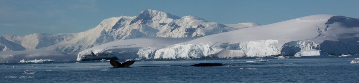
It was our last day in Antarctica and it was turning out to be a good one. For a start, the weather was beautiful. Bright and sunny. Barely a cloud in the sky. Best of all, for me, despite the brilliant sunshine, it was still cool and crisp. Perfect. In the morning we had seen more penguins than you can shake a stick at. We had seen one poor bird getting eaten by a leopard seal. There had been some great scenery, sea birds and seals. At lunch time the ship moved from Culver Island over to the much larger Anvers Island. In particular, we were at the entrance to a large bay surrounded by mountains, glaciers, snow fields and all the usual Antarctic features.

Zodiacs deployed, we all spread out around the bay. A nice feature of the Douglas Mawson is that it carries enough zodiac RHIBs that everyone can get out at the same time. No waiting for a previous group to come back in. We saw a leopard seal, calm and peaceful on an ice floe. A fur seal swam over to look at us. Then a whale popped up. And another. More whales. Whales right across the bay. As one especially enthusiastic cetacean spotter in the expedition team squealed loudly “Whale soup!”.

Several pods of humpback whales were bubble netting. The ocean just there must have been quite rich in krill. Bubble netting is a highly coordinated, cooperative feeding behaviour used to catch large amounts of krill. A group of whales works together to blow a complex, circular “net” of bubbles to trap prey, forcing them into a tight ball before swimming up through the centre to feed. Whales communicate to coordinate diving and feeding. One or more whales may act as the “driver,” while others act as the “blaster” (producing bubbles) and others as “blockers”. We could only see what was happening on the surface which was still fascinating. First thing would be a circle of bubbles forming in the water. This became more intense and then one or two humpbacks would appear, rising headfirst up through the circle. This was the first time I had ever seen the head of a humpback. More usually, you only see their backs and tails.  The whole group would then bob around for a while making great blows of water vapour into the air. Finally, they would dive and, a few minutes later, another circle of bubbles would appear.

Amazing to watch although, obviously, we had to try and keep our distance. Several pods were working the bay. Flocks of birds were following each pod marking them for us. This was all we did for a couple of hours. Drift around the bay following whales. I quite unashamedly present here the greatest number of whales that I have ever photographed at one time. Extreme luck really. Right place, right time. Truly wonderful to watch and also to think that, at long last, the whales are starting to come back from decades of brutal butchery.

Reluctantly, we eventually had to head back to the ship. Then, just like that, our trip was over. Not quite, first we had to steam north through the notorious Drake Passage back to Ushuaia. As darkness fell, we were already leaving the icebergs behind. At 60° S the wind and waves can go right around the planet without encountering land. Low pressure systems whip round here, building in intensity, giving rise to ferocious waves and winds. The reputation of Drakes Passage, the gap between Cape Horn and the Antarctic Peninsula, is well earned but stems mostly from an earlier age. An age where weather forecasting was close to guessing, when vessels travelled slowly and at the mercy of the winds. Today, plans and forecasts are much more reliable. I think I have crossed these waters eleven times now and only once, back then, did we encounter really bad weather.

We spent the day packing and feeling a bit deflated. It had been a truly remarkable trip. We had seen many amazing things. Sights, sounds and sensations unique to Antarctica. For just over a month, we had been thoroughly immersed in all things Antarctic. Up until just a few years ago, I had never really entertained the idea of returning south as a tourist. Our first trip to the peninsula, over a year ago, had mostly just annoyed me. In four days, we saw a tiny bit of the peninsula at arm’s length while being herded around like senile, geriatric sheep. This time, we got a real taste of it and my itch was properly scratched. There was still a small tendency for some of the guides to be a bit superior, contemptuous and slightly patronising. For the most part though, they were friendly and informative. They treated us as equals and shared a genuine enthusiasm for Antarctica. I think a lot of this comes from the leader, Howard, who seemed like a very sincere, sociable and enormously experienced guide.

A late-night mulling over the trip was followed by an early morning disembarkation in Ushuaia. A slightly brutal and dislocating completion of the voyage but the start of something new.

Culverville Island

This is Antarctic penguin central. Biggest Gentoo penguin waddle on the peninsula. At least 6,500 breeding pairs. That is a lot of penguins. Why are they counted in breeding pairs? First answer is that you need a number that is useful in comparing the size of different rookeries. A breeding pair represents potential new offspring. By counting pairs, researchers can calculate “productivity” (the number of chicks hatched or fledged per pair) to understand if a colony is thriving or in decline. Individuals include non-mating birds, young birds and the many wonderful old birds. Even if you could count these then what would the counts mean? Second answer is that it is easier. Pick the right time of year and all the breeding pairs have a nest. You can simply walk through the rookery counting nests. Might look like a small depression in the ground with a couple of rocks in it but to a penguin, it is a nest. Unlike penguins, nests stay still. They are intrinsically easier to count.

Most of the breeding pairs had long since finished breeding and gone fishing by the time we arrived. This still left quite a few penguins and a lot of smelly guano. We had a brief run ashore by zodiac. Gentoos are often quite curious. We are supposed to stay at least 5 m away from any birds. However, if you stand still and the bird comes to you, then the best you might be able to manage is to retreat a little while ensuring that you do not stand on the birds behind you. Many of the birds we saw were youngsters just losing the last of their fluffy chick feathers. Standing around waiting to take to the water for the first time. Penguins have no natural terrestrial predators in Antarctica, making them relatively fearless of humans. Large birds, such as the skuas and giant petrels, will occasionally take eggs and small chicks. They also scavenge carrion.

In the water, danger comes from killer whales and leopard seals. We clambered back into the zodiac and just as we pushed off from the shore a leopard seal came over to us. The previous day, we had encountered a seal that was curious about the boat. This one had brought us a penguin. The birds are fast in the water, like little torpedoes. Leopard seals are faster and young gentoo penguins on their first trip to the ocean make easy prey. This seal was playing with its prey. Like a cat with a mouse. It would let the hapless bird swim a short distance and then catch it again and bring it back to the boat. Almost felt as if the seal was showing off to us.

Obviously, we watched. A mixture of horror and fascination. Each time the poor penguin was dragged back it was getting weaker and more feeble with its fruitless struggling. I would have liked to rescue the battered bird but, not only was this quite impossible it would also not have been appropriate. We were observing a part of natural life in Antarctica. Something that happens right around the continent every day. Eventually the young penguin was dead. The seal was not done with it yet. They prefer to remove the skin with all the feathers before they eat. To do this, the leopard holds the penguin, by its head, and thrashes it back and forth. Takes a while and is very violent. Every few seconds the leopard seal would pop up in a great shower of spray as it whipped the bird through the air. Eventually the skin peeled back revealing a blood red carcass. The skin, feathers and feet drifted away on the surface of the sea chased by scavenger birds. We got a brief glimpse of the satisfied seal and then it too disappeared.

I think everyone in the zodiac was a bit stunned at what we had just witnessed. There was silence. Our driver, Kevin, thought we could try to circumnavigate Cuverville Island while we recovered our sensibilities. More penguins, more seals and some remarkable scenery. Once again we were incredibly lucky with the weather. Most of the time it is cold, windy, overcast and generally unpleasant here. Today it was sunny and lovely.

 We came across another leopard seal relaxing on a chunk of sea ice. He looked at us without concern and actually appeared to be quite cute. Then he yawned and showed us his substantial set of sharp teeth. Not so cute after all.

As we came around the island and were heading back to the ship, we saw a small wooden boat on an island. Strictly, it was just the remains of a small boat. A fur seal watched us carefully and then appeared to indicate to us which direction to go. The boat was something to do with whalers and had been deliberately chained up. Later I discovered that it likely dates back to around 1921.

With that we were done. A steady drive back to the ship after a very exciting morning.

Argentine Islands

We spent the night well away from the coast. The inner channel was clogged with icebergs. The ship stayed clear of this which meant a bouncy night in the open ocean. By morning, things has settled down as we headed back towards mainland Antarctica and the Argentine Islands. The ship eased along some ice choked channels until we were close enough to put the zodiacs in for a landing.

As we work our way north along the Antarctic Peninsula, the place is feeling less and less remote. After many days of not seeing another vessel or any sign of humans, they seem to be everywhere now. Just south of Galindez Island was a cargo ship involved in resupplying the Ukrainian Vernadsky Research Base. We also came across a couple of yachts. They can find a safe mooring here where the inner channels are too shallow to allow dangerous icebergs in.

A leopard seal took quite an interest in the zodiacs. Swimming around them and bobbing up very close. At one point it appeared to be cuddling one of the boats. We later found it had bitten through one of the inflatable tubes that make up the sides of the boat. Fortunately, the hull is made of several tubes and can get along fine if one, or even more, of these is punctured. Eventually, it went off to bother some of the Gentoo penguins and we could get on with looking at some quiet, peaceful, Arctic Terns. Medium sized, pretty birds with an understated toughness. They migrate, annually, from the Arctic to the Antarctic and then back again. Following the sun. A journey of at least 40,000 km a year.

We passed by the Vernadsky Base. They were remarkably busy with cargo operations, possibly their annual re-supply. Certainly, they had no time for us. The base used to be owned by the British. Back then, it was called Faraday Base. After the collapse of the Soviet Union, Russia refused to give any of the old soviet base to Ukraine. However, Ukraine wanted to maintain a presence in Antarctica and, presumably, assert its independence from Russia. In 1992, BAS agreed to sell the old Faraday base for just £1. This gave the Ukrainians what they needed and also got BAS off the hook for the cost of disassembling the base. With good environmental practices and standards this would have been expensive. Since then, the base appears to have worked very well for Ukraine.

A Dobson Spectrophotometer used at Faraday was essential in establishing some of the baseline ozone level data that led to the discovery of the atmospheric ozone hole. The instrument was later moved to Halley Base. In 1985, a paper was published by BAS (Farman, Gardiner, Shanklin) in Nature magazine, based on data from Halley and Faraday, showing the development of the hole. This surprised a lot of people, not least the Americans. Since 1978, NASA had been launching satellites with a Total Ozone Mapping Spectrometer (TOMS) instrument on board. Re-examination of the TOMS data showed that the hole had been missed because the low readings were being filtered out by the analysis software as erroneous data. With the software recalibrated from the Halley ground-truthing readings, the enormity and seriousness of the situation became readily apparent. The importance of this discovery cannot be overstated. Within two years, the Montreal Protocol was introduced. An international agreement that froze the production and use of ozone-depleting substances at 1986 levels and set the groundwork for phasing them out entirely. Today, the protocol stands as one of the most successful international environmental treaties ever implemented. It is proof that we can fix major climate problems if we try.

Some fur seals were eyeing us suspiciously. We ignored them and went to look at some Wilson’s Storm Petrels. There was a group of these tiny birds, along with some Southern Giant Petrels feeding from something in the water. I had been trying to photograph a Wilson’s petrel for a while. They are small and fast and very flighty.  They little perishers will not stay still for anyone. The giant petrels might have a 2 m wingspan and weigh over 5 kg. The Wilson’s however, come in at 40 cm wingspan and 40 g weight (think small fairy cake with gossamer wings). Properly tiny and almost impossible to spot and photograph in the open ocean. Now was my chance, while they were busy feeding. They have a tendency to dance on the water with their feet. This has caused to them being referred to as The Jesus Bird. They make a pilgrimage to land for breeding but spend most of the year, including the Antarctic winter, living and feeding deep in the ocean. Very small and very tough. So, although globally they are quite common, they are not seen all that often.

There is an even older British base a short distance from the working base. This is known as Wordie’s Hut and is a designated ancient site now. We were allowed a brief look around. Some of the kit and equipment was similar to gear I used during my time at Halley. Seems like I too am becoming an ancient monument.

On the way back to the ship we saw several groups of penguins feeding in the water. On land, a bunch of penguins is known as a colony, a rookery or, my favourite, a waddle. In the water they are referred to as a raft. They bob out of the water as they swim along so we get a raft of porpoising penguins. Gentoos are particularly prone to this sort of behaviour.

The Gullet

Next morning we were still in Marguerite Bay. On the east side near the peninsula. Dawn was spectacular. Clear, piercing blue sky. Bright sun. Almost no breeze. It was warm and pleasant out on deck. I spent some happy time taking photographs. In particular, I was impressed at how the mountains were encased in the sort of ice formations that you usually see in much higher peaks. Fluted faces reminiscent of the high-altitude Himalayas. Massive “rime ice” mushrooms, formed by fierce winds and moisture, typical of the great Andean peaks. The mountains here are no slouches. Many are over 2,000 m and would be extreme climbs because of the remoteness and weather conditions. To me, however, they have the character and appearance of much loftier peaks. This gives the area a sense of grandeur and magnificence.

The zodiacs were launched and we all went for a cruise. When I say “all”, I do actually mean most of the clients. There are 84 paying passengers on board and often over 80 go out on the boats at one time. Some of them in kayaks and the rest in the zodiacs. At Stonington, every single customer went ashore, all 84 of us and quite a lot of the crew. This is unusual for an expedition type cruise where there is often a significant contingent that are just along for ride. For us, it was not to be missed.

We bobbed around in the brash and small icebergs. There was a leopard seal that was not at all interest in us. Some bits of unusually clear and dense ice. The cutest baby Weddell seal and a couple more Royal shags.

Back on board, after lunch, we started steaming north and into The Gullet. Your gullet is how food gets to your stomach from your mouth (usually). Also called, the oesophagus. The Gullet is a narrow, 11 nm long, glacier-lined channel in Antarctica separating Adelaide Island from the Antarctic Peninsula. From the north, it is a scenic, ice-choked shortcut to Marguerite Bay, framed by high ice cliffs and towering mountains. It is a renowned, highly scenic, and challenging route. Obviously, our skipper was up for it. Still fresh from setting a world record for southerly navigation, he was on a roll.

We passed by Rothera Research Station. This is the main BAS base for field trips and access to West Antarctica. Unfortunately, we passed so far east of the base that very little was visible. This was a pity. I would have liked to pop in for a brew. Very slightly further north we got mugged by Killer Whales. I don’t mean they attacked us or anything, just that there were hundreds of them. Maybe not literally hundreds but certainly way more than I have ever seen before. Pods of eight or ten individuals kept swimming past us. It was amazing. I took hundreds of photographs and I do mean hundreds this time. For over an hour, we watched groups of Orca swimming south as we were steaming, very slowly, north.

After the Orca had passed behind us, we came back to embracing the incredible scenery. Occasionally, the wind would drop and the sea become calm and mirror like. Diane got extremely excited about this. She loves a good reflection and these were right up there with the best of them. It was a glorious vista. Rugged and peaceful. A brief moment of calm and solitude in a place more usually unwelcoming and forbidding. Our reverie was shattered by the sudden appearance of another ship. The SH Vega. Another cruise ship. The first other vessel that we had seen since leaving McMurdo Sound a fortnight earlier. They had come the easy way. We had come the long way round so we felt we had bragging rights. We did not come close to the Vega and before long she was disappearing behind us. Two ships passing in the early evening.

We continued through The Gullet. Squeezed past a couple of icebergs that were almost blocking the channel and eventually emerged to the north. From here, the inside passage was badly clogged with ice so we moved out to sea and had a rather bouncy night heading for the Argentine Islands.

Stonington

After another day at sea, we arrived at Marguerite Bay off the west coast of Graham Land. The sea day had been quiet and pleasant. Sunshine and a gentle swell. We particularly enjoyed eating dinner while watching albatross and ice bergs float past. I also spent some time on the back deck photographing sooty albatross.

At the north end of Marguerite Bay is Stonington Island. It is only small. 25 m high in the centre. The island is right at the snout of Northeast Glacier and used to be connected to it by a snow slope. The British and Americans had bases here in the 1940s. The British base was used up until 1975. Both bases are now designated as historical monuments. Sir Vivien Fuchs wintered here in 1948 and again the next year when the relief ship failed to arrive. He later went on to lead the first trans-Antarctic expedition and became director of the British Antarctic Survey until 1973. He was a newspaper headline writers dream. For example, in describing a two day sledging trip the headline might read “Sir Vivien Fuchs off for the weekend”.

We had an easy landing by zodiac on Stonington Island. The weather was warm and sunny. The scenery spectacular. Whoever first chose Stonington as a site for a base chose well. To the north is the massive ice wall of the end of Northeast Glacier. This creaks and groans as the ice shifts and occasionally bits fall off into the water. South and west is Marguerite bay filled with icebergs and framed by mountains. Due east is the Bellinghausen Sea. Open ocean clogged with ice. To the west, the mountains rise towards the centre of the Antarctic Peninsula. I have no doubt that, back in the day, many hours were spent in contemplation of this magnificent vista, pipe in one hand and hot cocoa in the other.

Our first stop was to look at some Imperial Shags. The difference between cormorants and shags is elusive. Often there is a difference. A certain type of birder will rattle on for ages describing them. However, there is no consistent scientific distinction between the two although they generally refer to different species within the same family.  English-speaking sailors originally assigned the names somewhat haphazardly. A lot depends on where you are or who you ask. Imperial Shags are also known as Blue-eyed Cormorants.  The cormorants are described as “possessing a distinctive ring of blue skin around its eyes, a orange-yellow nasal knob, pinkish legs and feet, and an erectile black crest”. Sadly, it was not breeding season so no erectile crests to be seen.

We wandered around the beach past the remains of two tracked vehicles and a sleeping seal. We visited the huts. There was not very much going on in either of them. As is often the case with museum type scenarios, I find the stories fascinating but the empty, wooden buildings less so. On the way back to the ship, we came across some moulting Adelie penguins. They typically look a bit sad and fed up while they are waiting for their new coats to grow. They can also appear a little comical. I very much liked punk penguin with the erectile Mohican hair piece.

Back on the ship, things got silly. It was time for the polar plunge. People jumping into he freezing cold water for no good reason. Participants needed to do a medical assessment. The medics were standing by with warm blankets and a defibrillator. Diane and I chose to remain warm and comfortable. We joined the other onlookers leaning over the back of the deck. One by one about 20 people appeared on a platform jutting out from the stern. They jumped in the water, got dragged back aboard and then ran off to resuscitate. Everyone survived and then it was time for a barbecue.

Dining al fresco is always fun as the temperature drops below zero. You wrap up warm and then try to manipulate the cutlery with your gloves on. Food was cold long before it got to the table. The wine, however, was at just the right temperature, so long as you stuck to white wine. We were treated to a spectacular sunset and not long after that brightly shining gibbous waxing moon rose over the mountains to the east. Great place to build a base.

Peter 1st Island

Four consecutive sea days. We needed to move well away from the coast to avoid the great rafts of sea ice that are starting to build up. At this time of year, it is too easy to get caught up in the drifting, freezing ice and, potentially, stuck. We had a ship full of Antarctic enthusiasts but even so, nobody wanted to stay here for the winter. First day out there was not much to see. Pancake ice and fog. The occasional iceberg lurking in the distance. Fortunately, the radar was undeterred by fog. Next day the visibility improved. There was very little fresh ice but way off to starboard we could catch the odd glimpse of the ice edge. We stopped for whales. A large pod of feeding humpbacks. Many people came out on deck to try and grab a photo. The passing days settled into a different rhythm. Whale watching, bird watching, lectures, films, gym sessions. Eventually, we rounded the worst of the pack ice and could head more south. At least a little way.

Peter 1st Island is a very remote and rocky island. Seldom visited. It is remote on many counts. Geographically, it is simply a long way from anywhere else. 450 km off the Antarctic coast – not that there is anything or anyone at that bit of coast. Logistically, very few vessels cross the Amundsen and Bellinghausen seas of Western Antarctica. Nobody comes this way except the odd scientist and a few lonely tourists. For most of most years, the island is usually solidly surrounded by sea ice. Locked in a deep, frigid winter. Gloriously isolated and inaccessible. Societally and historically, there is nothing here. No bases, no old huts, barely anyone has even landed here. There was a small hut once but it has long since been blasted away by the fierce storms that pass as normal weather here.

The island was first sighted by Bellingshausen in January 1821 and named after Peter 1st of Russia. A hundred years later, Larsen was the first to set foot on the island and claim it for Norway. It is small, about 10 km x 20 km, volcanic and almost completely covered by glacier.

We approached from the east. Landings had previously been made on this side. What we found was dark, steep and forbidding. The cloud was low and grey. A stiff, cold breeze made standing on deck quite unpleasantly cold. The swell was substantial. The sky was dark and ominous. We could not see more than a couple of hundred metres up the cliffs. Peering through the gloom, it was just possible to see great seracs of ice and cornices blown snow. Tons of a Damoclean ice perilously overhanging the cliffs. There was no safe place to land here.

The ship backed out and then sailed, north-abouts, to the western shore. As we rounded the northern limit, the sun came out. Above the island, the clouds were lifting. Thick, rounded lenticular clouds were forming high above us. We were greeted by the sight of more steep cliffs, now iridescent in the bright sunshine. The ship steered towards an immense slice of cake. Layers of red and black volcanic ash iced with layers of thick, brilliant white snow, névé and ice. Then the wind stuck. A fierce katabatic blowing straight off the mountains. Katabatic winds are strong, cold, gravity-driven winds that rush downslope from high-elevation ice sheets to the coast. Caused by radiative cooling, these dense, heavy air masses often reach hurricane-force speeds. The ship again backed off as the winds gusted to over 50 knots.

On the island, the cloud continued to lift. The sky was clearing elsewhere and the bright sun was actually beginning to feel warm. We moved back in, a little further north and just past a small, gravel spit, found a place to anchor. The winds had dissipated, we were shielded from the ocean swell and, at last, we could attempt a landing.

We did not land. The zodiacs were launched and we had a pleasant cruise. Close to the shore it became apparent that a general landing would be risky. There was still a significant swell and the shoreline offered very few safe places. Two of the expedition team, fully equipped with dry suits, leapt ashore and scrambled around for a few minutes. A rare landing had been made and we were part of it. Our driver took the boat in close to some cliffs. Diane reached out and touched one of the most remote places in the world. A few moments later, a small avalanche came down the wall close to where we had been. Mostly just powder snow, it would probably have been more unpleasant than dangerous. Even so, best avoided.

Back on the ship, we got warmed up. This was helped by hot chocolate drink served with Baileys. Then I was back on deck for a while, photographing the amazing icebergs as we set sail for the Antarctic Peninsula.

Bay of Whales

Leaving Cape Crozier, we set off along the edge of the Ross Ice Shelf. At 800 km wide, it is the largest ice shelf in Antarctica. About the same size as France. The ice edge is a vertical cliff up to 50 m high. Most of the ice shelf is floating. 90% of it is below water. Hundreds of metres thick. Sailing below the ice cliffs is quite remarkable. A single, solid, bright white line stretching from horizon to horizon. Almost featureless until you zoom right in with the binoculars. Even then it is mostly just flat white ice. Sharp and hard and unforgiving. For over two days, all we could see was this great barrier of ice.

At the eastern end of the ice shelf is an area called the Bay of Whales. This has enormous historical significance. Amundsen started his trip here when he beat Scott to the South Pole. Roald Amundsen set up his base, called Framheim, on the ice shelf and stayed here for the winter. Later, Admiral Bird, built a base called Little America in roughly the same location. There were several generations of this base. All the bases suffered the same fate. First, they got buried by snow and disappeared into the ice. Later, the ice will have broken off and the base would have disappeared down to bottom of the ocean. Sadly, despite the many iconic stories, there is nothing left to see here. Just snow, ice and seawater.

We could not even see the sea. It was freezing over. A thick layer of pancake ice and a lot of fog. Sea fog or ice fog. Caused by the sea being much warmer than the air. Outside, it had dropped to -20°C. The decks were covered by ice. So were the railings, the lifeboats and even the air intakes. A thick layer of rime ice on everything. The blocked vents caused something in the heating boilers to break. The crew were very sketchy when it came to giving us details but my guess is that some heating element burned out because of poor air supply. This is a newly built ship and quite possibly has never been somewhere this cold before. It is designed to operate in the Antarctic but that is not the same as actually testing a whole big vessel in freezing weather. We are in a Chinese built ship, registered at Nassau in the Bahamas, with a captain from Panama. What could possibly go wrong in the Antarctic?

While this drama was going on in the engine room, up on the bridge they were getting quite excited. The southern side of the Bay of Whales is a mass of shifting shelf ice which is constantly breaking off into icebergs. The shape of the navigable part of the coastline was always changing. Exactly now, it was possible to reach a point that was further south than anyone had ever sailed before. In any type of boat or ship. Obviously, the skipper found this irresistible and went for it. 78º 44.405’ S A new world record. It was reported within hours by Wanderlust magazine.

The excitement was short lived. We did not want to hang around. It would be very easy for the ship to get stuck in ice around here and our heating had just packed up. A day later, the sea surface was still covered in pancake ice but it was much thinner. We had moved well away from the sea ice that was spreading out from the coast. The outside air was still below freezing but this was 15°C warmer than in the Bay of Whales.  A little life had been coaxed out of the heating system. Some parts of the ship were cold. A few passengers were moved to different cabins. Our cabin remained lovely and warm.

Cape Crozier

The western end of the Ross Ice Shelf is pinned in place by Ross Island. Cape Rozier is last bit of land before the long, long ice cliffs. 800 km of steep, high, white ice. We got there in the morning and went out in the zodiacs.

It felt chilly. A few degrees below zero augmented by a stiff breeze. We set off along the shore where there are large colonies of Adélie and Emperor penguins. As it was elsewhere, nobody was home. There were a few stragglers standing around but mostly just empty, dark volcanic beaches covered with a thick layer of lighter coloured guano.

The cape was discovered in 1841 by James Clark Ross’s polar expedition. It was named after Commander Francis Crozier, captain of HMS Terror. Four years later, Crozier with Terror and HMS Erebus, Ross’s other Antarctic ship, attempted the Northwest Passage at the other end of the planet. We encountered these sturdy, historic ships, or at least the site of their wrecks, about 18 months ago.

At the end of the beach was an interesting little cove made by the shelf ice. I was fascinated by some icicles with balls. Thin, icy columns cause by melt water had grown down from the ice until they touched water. Then the freezing sea water accumulated on the end like a little frosty bauble. This made some gloriously intricate and delicate patterns along the bottom edge of the ice cliffs.

Just around the corner was yet another phenomenon I had never seen before. Great plumes of spray jetting out of the top of the ice cliffs. You see this sort of thing occasionally in stone sea cliffs. A cave close to sea level has an outlet to the surface. When a wave washes into the cave, water gets pushed up and sprays out above the cliff. I think something similar was happening here albeit in a much more dynamic way. Sea water was forcing open a crack in the ice. The crack would originally have been a crevasse. Some combination of melting and re-freezing was causing spectacular blow holes to appear in one section of cliff. There was something like half a dozen of them in just a short section. A first glance they looked like whales blowing but obviously there were no whales on top of the cliffs.

Ice was accumulating on the rubber boat and on my hands. In the second hour of sitting in the boat ,without really moving at all, bits of me were starting to go numb. I think everyone got a touch hypothermic by the end of the trip. It was, however, spectacular and well worth getting out of bed for.

Cape Evans

Another day, another hut. This time it was Scott’s hut on Cape Evans. Considerably larger than Shackleton’s hut at 15 m by 7.5 m. Prefabricated, well-made and well insulated with dried seaweed. Lighting was by acetylene gas. A small gas generator is by the door. I cannot find a description of how this worked. I think it will have used calcium carbide. Dripping water onto carbide makes acetylene gas. I used to have a caving lamp that worked like this. It has quite a distinctive smell but makes a good light and will have helped warm the hut as well. If carbide was used, then it will probably have been all removed by now. It is quite reactive and a build up of acetylene can be explosive.

A stable was added to the side of the hut and a utility room. Heating came from the kitchen range plus an additional stove in the officers’ quarters. While Shackleton was completely egalitarian over the layout of his hut, Scott maintained a clear class division. The hut is separated into two parts with a room divider made of packing cases. Officers and men even had separate dining tables. The hut has been beautifully restored. It looks just as it might when it was in use. Maybe not exactly the same but similar or reminiscent, anyhow. In the stable are a pile of penguins and a palette of seal blubber. The dark room has chemicals on the shelves. A harness for pulling sledges is hanging off a bunk. The kitchen looks well stocked. There is a penguin on a side table all ready for dissection and a newspaper dated 1908.

The hut was built in 1911. That winter 25 men over-wintered in it. In the early summer, 16 men set off for the South Pole. In the final push, Scott and four others made the pole but never made it back to the hut. One of many tragic and heroic stories from Antarctica. Several other trips were made from the hut. A winter trip to Cape Crozier almost ended in disaster. A northern party sailed to Cape Adare and ended up spending two winters. The second, in a snow cave where they suffered appalling conditions and extreme weather. A geological expedition went essentially to plan. However, the second trip got into trouble and were eventually rescued by ship off the sea ice.

We were told to keep our voices low when we around the hut as a sign of respect. This reminded me of when we visited the Sistine chapel in the Vatican. A guard there told me to remove my hat as a sign of respect. I was dying to ask how he knew God had a problem with hats. The guard seemed a bit stern and devoid of a sense of humour, so I kept quiet. Entry and exit to the hut was carefully controlled. We had to clean our boots. Only four at a time inside. No rucksacks. No touching. As we were leaving the hut, I really wanted to say, “I am just going outside and may be some time” but on balance it seemed better to keep quiet. Too many people looking profoundly serious.

The hut was reused in 1915 when Shackleton’s Ross Sea party got into trouble. Fortunately, the well-stocked hut provided a relatively comfortable refuge until Jan 1917 when Shackleton arrived to rescue them. The hut was untouched until 1956 when it was dug out by an American team and found to be in a remarkably good state of preservation. Since then, it has been maintained to give visitors a little insight into what life would have been like.

At Hut Point is Scott’s first hut. This was our destination for the afternoon. Hut Point is also the location of the McMurdo base run by the USA. This is, by an order of magnitude, the largest base in Antarctica. We were told that the wintering team, all 200 of them, were just settling in and could not accommodate visitors. By way of comparison, my wintering team at Halley was just 18 people. Our expedition team also found out that it was impossible to get to Discovery Hut because the remains of the sea ice formed a barrier. We sailed past McMurdo base slowly to get a good look at it. Just around the corner is Scott base. This is the New Zealand base. A modern looking base painted the same green as the hut at Cape Bird. New Zealand green. Obviously, a tiny base compared to McMurdo.

Further on we came to one of several runways. This appeared to be a thoroughly busy place. We watched an aircraft take off. As evening fell, the ship bobbed around in the pancake ice by the edge of Ross Ice Shelf. A group photograph was done here. After this we went to bed and the ship set off to sail around to Cape Crozier.

Ross Island

Ross Island is interesting. It is not very big, just 80 km across. McMurdo base is there. The most populous base in Antarctica. Up to 1,200 people. Run by the USA. Nearby, Scott base is run by the Kiwis. They also have a hut to the north of the island. There are three historic locations, restored wooden huts from the Heroic Age of Antarctic Exploration. The island also has two volcanoes. One is considered extinct while the other smoulders away, venting smoke almost continuously. The land is all snow covered with five large glaciers radiating from the centre. One side of the island is effectively connected to mainland Antarctica by a permanent ice sheet. The ocean on the other side freezes every winter but is navigable for part of the year. The world’s most southerly port, at Hut Point, is typically opened by ice breakers in the spring. From here a seasonal marked route runs 1,600 km to the South Pole. Greenpeace once had a base on Ross Island. It really is an interesting place.

Our first stop was at Cape Bird. Given all the potentially interesting locations on Ross Island, this is possibly quite low on the list. There is a small hut for scientific observations. Owned by NZ, there is no-one there at the moment. To one side, between the hut and glacier, is one of the world’s largest Adélie penguin rookeries. Except, just now, as elsewhere, the birds have all gone. Only a handful of Skuas with some late chicks, a few moulting penguins and a massive smell. The sun was out. There was not much breeze. The prurient penguin pong was prodigious and pungent.

We walked along the beach as far as we could go. Then back again, a slightly different way. There were a few seals snoozing by the waters edge. There were a lot of penguin feet. Many chicks die before reaching adulthood. Our guide assured us that only 10% survive the first year. The reality is between a third and two thirds but even so that is a lot of dead penguins. Skuas clean up the dead chicks. They are also responsible for some of the dead chicks being dead. However, Skuas appear to not like the feet. Little desiccated penguin feet are scattered all over the beach.

In the afternoon, we went to visit Shackleton’s hut. This was much more interesting and did not involve a beach of penguin bones and guano. First, we had to sail across the bay to Cape Royds. This gave us a chance for lunch and to watch some orca. We saw several pods of Ross Sea Killer Whale. They are a distinct species, endemic to the Ross Sea. None of the whales came particularly close to the ship. In fact, they all appeared to keep roughly the same distance. Near enough to be seen, far enough to deny a good photograph.

Shackleton’s hut is a designated historical monument controlled by The Antarctic Heritage Trust (New Zealand). The hut was prefabricated in Britain and taken south for the first expedition led by Shackleton. The intended location proved inaccessible, so it was erected at Cape Royds. Establishing the base was difficult. Unloading the ship, the Nimrod, took nearly three weeks. They were hampered by harsh weather, ice conditions and disagreements with the ship’s captain. 10m by 6m, the hut was home for 15 men during the winter of 1908. From here, the expedition achieved the furthest ever south (88°23′ S), the first ascent of Mount Erebus and the discovery of the location of the South Magnetic Pole

The hut was left in good condition with enough supplies for 15 men for a winter. A letter, inviting any subsequent party to use the hut, was left inside. The door was locked and the key prominently nailed to the door. More recently, the Heritage Trust have repaired and reinstated the hut so that it still looks as if Shackleton only just left. The dog kennels are outside. Food and other supplies are inside. Fortunately, the cold, dry conditions of Antarctica help preserve the hut as a museum. Access is carefully controlled and restricted. We needed to clean our boots and only four people were allowed inside at a time. In 2010, several intact cases of whiskey were discovered underneath the hut. The original distillery has now recreated the taste of Shackleton’s whiskey. You can buy a bottle, for a premium, but that does include a donation to the Heritage Trust.

We wandered around the area. There is a small hill with some nice views. A frozen lake with a few penguins sliding across it. Diane did her penguin impression. I wondered about how Shackleton’s hut got its water supply. Usually, at a small Antarctic base, the water comes from melting snow. You need a good supply of clean snow. It is cut into blocks and melted in a large pot on the stove. When we visited the hut, it was surrounded by penguins. Extremely cute but far from ideal when it comes to clean snow.

In the evening, we headed across the sound towards Cape Bernacchi. The sun only sets for about three hours at night. Late in the evening, it was low but still bright. We had some wonderful views of the mountains and could watch ice starting to form on the water. When the sea first begins to freeze over it forms little circular patches called pancake ice.

Cape Hallet

100 km or so south from Cape Adare is Cape Hallett. It is a very picturesque area dominated by the Admiralty Mountain Range. The mountains were discovered in January 1841 by Captain James Clark Ross, Royal Navy, who named them for the Lords Commissioners of the British Admiralty under whose orders he served. Back then, naming geographic features after your sponsors was a well-established and successful ploy for obtaining further sponsorship.

A large Adélie penguin colony is located on the southern side of Cape Hallett. This is where we went zodiac cruising. Conditions were perfect. Calm water, sunshine, a few icebergs with seals lazing around on them and the distinctive smell of the penguin rookery. As with the other places we have visited, most of the penguins have left now and gone to sea. Just a handful of moulting penguins and a lot of guano to show for it.

We pottered around for the best part of two hours. Looked at some penguins. Looked at some seals. Saw a leopard seal but could not get a good picture of it. Mostly because it was sound asleep and not at all interested in us. We looked at some rocks and listened to someone who knew a bit of geology. That was quite interesting. Volcanic features. We looked at some glaciers. One of the guides started talking nonsense. They do this occasionally. They assume that we, the clients, know absolutely nothing about where we are. So, sometimes, to fill the silence, they start telling us stuff as if they know what they are talking about. It is best just to let them get on with it. They never suspect that, sometimes, old people know things.

Back on the ship there was talk of a weather window. We were heading right down to the bottom of the Ross Sea. This is, traditionally, the most reliable way to get south. Shackleton, Scott and many other heroes came this way to Ross Island. Scott named it after Ross. He did not have to. Ross was dead by then and Scott’s funding came from Royal Geographical Society and the Royal Society. Ross, however, was a pillar of Antarctic exploration and this sort of thing went well with the London based leather armchair explorer societies. Our issue was that Antarctic weather is changeable and occasionally ferocious. To take advantage of the weather window we needed to get on with getting to Ross Island.

The zodiacs were packed back onto the ship and we set a course south. For the whole of the next day, we made good speed. No sea ice, very few icebergs, beautiful sunshine and just a few birds following the ship. The expedition team drummed up a few talks. I got on with this blog. Diane got in some essential sleeping time. At Ross Island things were going to get very busy.

Cape Adare

We are woken every morning by an announcement on the ship PA system. Fortunately, Howard, the expedition leader, has quite a gentle voice. His wake-up call with the weather and daily program is more Radio 4 than Heidi Hi. This is a good thing because otherwise I would need to work out how to disconnect the speaker in the cabin. It can be a bit of a guess as to what time we are going to be woken. This particular morning it was before dawn.

Sunrise proved to be quite spectacular making the early start worthwhile. Tabular icebergs (the big flat ones) were floating past. Seabirds were flying around the ship. A pod of killer whales went past. It was all turning out to be an extremely exciting morning.

After breakfast and a second pod of Orca we arrived at Cape Adare. Historically this place is extraordinarily significant. It is the site of the first ever landing on mainland Antarctica. It is also the first place anyone ever spent a winter on Antarctica. Biologically it is the location of the largest Adélie penguin rookery in the world. The first big impression Cape Adare made with me was the stink. The beach has an entire geological layer of penguin guano. Relatively few birds are here at this time of year but over 200,000 breeding pairs not so long ago. Today the sun is out and the beach area is warm, soft and vibrantly pungent underfoot.

We went ashore in zodiacs to have a look at the huts. Through the Antarctic Heritage Trust the site is registered as an Antarctic Specially Protected Area (ASPA 159) the highest level of protection available under the terms of the Antarctic Treaty. We need to tread carefully and speak in hushed tones. In January 1895, Norwegian explorers Henrik Bull and Carsten Borchgrevink landed here. Borchgrevink claimed to be the first to step onto the Antarctic mainland. Or it might have been Leonard Kristensen, ship captain, as cited in expedition accounts. Or Alexander von Tunzelmann, a 17 yo deck hand who claimed he jumped out to steady the boat for the others. Borchgrevink came back in 1899 as leader of the Southern Cross Expedition, also known as the British Antarctic Expedition. They erected two huts in which to spend the winter. The very first winterers and the very first buildings in Antarctica. This was the first British venture of the Heroic Age of Antarctic Exploration. Later, Scott and Shackleton would become famous for their exploits. But nobody particularly like Borchgrevink. He was Norwegian and we would have preferred a reliable British Naval Officer. He also had an abrasive personality that appeared to upset pretty much everyone he ever dealt with. These two traits led him to becoming the first Antarctic hero that you never heard of. He received some recognition thirty years later. The Royal Geographical Society admitted “justice had not been done” to his work and awarded him the Patron’s Medal.

Members of the Northern Party of Scott’s Terra Nova Expedition over-wintered at Cape Adare in 1911 and 1912. They erected one hut, which has fallen into ruin today. The Norwegian built huts have fared much better. Zoologist George Murray Levick made observations of the penguins throughout the year and was horrified. He saw “depraved behaviour” including “hooligan penguins” that exhibited homosexuality, necrophilia (mating with dead females), sexual coercion and the physical abuse of chicks. Returning to Britain, his paper Sexual Habits of the Adélie Penguin was deemed too graphic for the official expedition report. His lost paper was rediscovered at the Natural History Museum and published in full in 2012. What Levick regarded as “moral failings,” modern biologists consider the result of sexual inexperience in young birds and high hormonal levels during the short, intense breeding season. Life can be hard as a teenage penguin when nobody understands you.

Diane had a quick look inside the huts. Despite their enormous historical significance, they actually look like a pair of old garden sheds. We wandered around in the penguin poo for a while. Back in the day, superior quality guano was a rich source of nitrogen for fertiliser and gunpowder. Borchgrevink the unloved, had even submitted a commercial proposal to collect the droppings.

After the breeding season comes the moulting season. A catastrophic moult is critical for survival. It replaces every single feather to ensure they remain waterproof and insulated. Typically lasts between 2 and 4 weeks. Without their waterproofing, penguins cannot enter the water to hunt. To survive, they must gorge on food before the imposed fast. This can double their body weight which makes them extra tasty to predatory killer whales and leopard seals. At this time of year, most of the birds have headed off to sea. The remaining slow moulters stand around looking shaggy and a bit despondent.

We were saved from nasal assault by the offer of a zodiac cruise. This gave us the opportunity to look at some odd shaped bits of floating ice. As icebergs melt and occasionally roll over, they can assume some strange patterns. Glacial ice typically forms in annual layers. This striation combines with patterns caused by wave action, meltwater and gas bubbles to form a remarkable range of shapes and textures. We also saw a few minke whales, a few Weddell seals and the first Emperor penguin of the trip.

Bellany Islands

Sailing south from Macquarie Island we had a couple of sea days. Nothing much happening. Nothing much to see. I spent some time on the back experimenting with camera settings. My relatively new Canon EOS R5 MkII is a lovely camera but has way too many options. It also has way too many complex and fiddly controls to manage all the complex and fiddly options. A lot of learning is needed to master the beast. I try and take this in small and manageable slices.

Antarctica is in a state of political limbo. Slices of it are claimed by various countries. Many of these claims are overlapping. Antarctica has no permanent population, no citizenship and no government. There is no Antarctic sovereignty. Personnel present in Antarctica are always nationals of some other country. In 1959 the Antarctic Treaty was ratified by most of the countries with a stake in Antarctica. Think cold war. This was primarily an arms control agreement. It designated the continent as a scientific preserve, established freedom of scientific research and banned military activity. To date this has worked well. There have been a few minor skirmishes but the treaty serves everybody’s interests, so far, so it prevails. I worked in Antarctica 35 years ago and was always extremely impressed by international spirit of scientific cooperation it engendered. Unfortunately, in my opinion, the robustness of the treaty is like a house of cards. To date, Antarctica has only been useful for scientific research. That is changing. When I worked down south, there were no tourists. None. A half dozen brave people in yachts would visit the very northern tip of the peninsula. Last year there were 120,000 tourists. Numbering a mere 5,000, the scientific community is in the minority these days. What is more, these tourists not rough and tough hardy types. Far from it. They are mostly of the retired demographic enjoying a comfortable lifestyle. We are spotting icebergs from the bar of the observation deck while sipping a gin and tonic and nibbling a few salted cashew nuts.  

The winter is still harsh. Less than 1,000 people on the whole continent and no tourists. No doubt this will change. However, I am not suggesting that tourism will be the problem. To date, the increase in visitors appears to be benign. Antarctica is uniquely vulnerable but even so, it is a whole enormous continent. 120,000 people spread quite thinly. The International Association of Antarctica Tour Operators (IAATO) is the tourism body for self-regulation. They report to the Antarctic Treaty Consultative Meeting, an annual forum for Antarctic Treaty nations to exchange information, discuss matters of common interest, and formulate measures for managing the Antarctic region. This is voluntary self-regulation. IAATO is all set up to look very official. The implication and likely ambition, is that for a tour operator to work down south they will need to be a member. Like most standards, it primarily benefits the organisations that set the standards while putting barriers in the way of aspirants. I would anticipate that getting the necessary governmental permissions to visit Antarctica is greatly facilitated by membership.

Antarctica will get into trouble at some point on the current global socio-political trajectory when technology and resource scarcity intersect. The inauguration of President Trump initiated post-truth politics. Since then, we have seen a collapse of the social growth of civilisation in favour of capitalist greed and isolationism. Events such as Brexit, the reappearance of war in Europe and Trump’s second term are points on a line that reinstates a world order based on power and nationalism. As, and when, necessary resources in Antarctica become economically viable to access, one of the superpowers will be there. No amount of waving the Antarctic Treaty documents will make any difference. While staring out of the cabin window with the gloomy thought in my head, I saw the first iceberg go past. This was much more interesting. Not far ahead was the first sea ice. A strip of loose, brash ice that had probably been floating around for a while.

Next day, we were bearing down on the Bellany Islands. A remote, uninhabited volcanic archipelago, approximately 325 km north of the Antarctic coast. Discovered in 1839, the chain, is heavily glaciated, features steep cliffs, and is rarely visited due to harsh weather and ice. We aimed for the middle of the three islands. This meant we has to cross the Antarctic circle to get there. The event was taken as an excuse for celebration. King Neptune visited the top deck. There was cheering, photographs and a toast. I avoided the nonsense and got on with trying to master the camera.

Meanwhile, as we closed in on the shelter of the islands, the wildlife began to appear. Seabirds, a few penguins standing around on ice floes and whales. A lot of whales. Mostly sperm whales, I think. Every few minutes there seemed to be another puff of water vapour from a whale blowing.

The zodiacs were put in the water and we had a short cruise between Sabrina and Buckle Islands. The wind had picked up again making the sea quite choppy. It was mere minutes before we were all soaked by salty spray. But it was worth it. There was a small group of whales feeding and we could get close to them. An intense flock of cape petrels marked the spot and every couple of minutes one or more whales would pop out of the water. Difficult to take photographs with the cold wind and the spray but an amazing privilege to watch. Back on the ship, we had a hot shower and then settled down with a glass of wine to be served an excellent meal. Such is the way of the modern Antarctic explorer.

Deception Island

Our last day in Antarctica. We had landed on some islands, landed on mainland Antarctica, landed on sea ice and cruised round icebergs in a RHIB. Some had camped out in Antarctica. All the boxes were ticked. For many this is the long and short of Antarctica. They have the t-shirt and in future travel conversations they will say that they have done Antarctica. Of course, they haven’t. Not even close. Antarctica is not a small island, not even a country, it is an immense continent. The world’s fifth largest continent. As big as the USA, bigger than Europe and twice as big as Australia. It is immense and complex with many different terrain types, weather systems and environments. Admittedly, most of the environments are cold by human standards but that does not detract from the diversity. For much of the year travel is impossible. The only way to get to know Antarctica is to go there and stay there. Possibly for years. So, while there are some people that can undoubtably say that they know Antarctica, a few that can honestly say that they have done it, they are very few and far between.

Many years ago, I experienced a little of Antarctica. It affected me profoundly and left me with a persistent urge to see more. I enjoyed my time with the British Antarctic Survey (BAS). I worked on some interesting projects and really liked the international spirit of cooperation in science. Despite this, I never had the right attitude or willingness to conform needed to be a long-term employee. This came to a head when I asked for three months unpaid leave. My friend Rik and I had been planning a climbing trip to Nepal for over a year. When I approached my boss about this, he said no. He had been looking for an excuse to get rid of me. Somehow, I always thought I would go back to Antarctica but not as a tourist. That route never appealed to me. The years rolled on, I built a company, sold it, retired and it dawned on me that being a tourist was my only route back. Our trip to Antarctica with Hurtigruten was similar to most tourist trips. A day or more sailing across Drake’s passage, a few days pottering around the peninsula and then back to Ushuaia. It was fun and scratched the itch. But only a little. I saw some parts of Antarctica that were new to me and it made me think about just how much more there was. Enough ruminating. This was our last day and we a job to do.

Deception Island is an active volcano in the South Shetland Islands. Its unique landscape comprises barren volcanic slopes, steaming beaches and ash-layered glaciers. It has a distinctive horse-shoe shape with a large flooded caldera. This opens to the sea through a narrow channel called Neptunes Bellows, forming a natural sheltered harbour. It is one of the only places in the world where vessels can sail directly into the centre of a restless volcano. We arrived at the Bellows mid-morning. The weather had not improved at all and remained stubbornly overcast. The Bellows is an imposing entrance named after the way the wind can funnel between the rocks. We slipped through without problems and anchored in the bay.

The remains of several bases are spread along the shore. Whalers put up the first buildings later followed several scientific bases. BAS had quite a substantial base there for a while which included an airstrip and large hanger. In the years before 1970 there was substantial volcanic activity which led to the island only being used during the summer months. The Argentinians and Spanish still retain a presence although the main use for the island these days is tourism.

We were landed on the black beach and allowed to walk along the shore. In places the sand steams with geothermal activity. There were a few gentoo penguins and some very sleepy fur seals. At the end of the beach was a track across a snow field to shallow saddle. Queues of people were plodding up here and we joined the lines. At one point I stepped up higher to an easier looking trail and promptly got told off by one of the many expedition crew guarding the route. This was one of those times I had to try really hard to not say what going though my head. One reason to not cause a fuss what that, in keeping with the islands name, we had our own bit of deception to do in memory of my mother. She visited this area in 2018 with Diane. It is a long story but essentially mum wanted to come and see where I used to work and understand a little of why I talked about it so much. At the time, she did not like Diane and clearly felt that Diane and I should not be together. Practicalities dominated however and Diane was the only available travel companion. Fortunately, they came back the best of friends and burbling about penguins. They remained firm friends until Polly passed away last year. The ridge overlooking the ocean in one direction and the beach in the other seemed an appropriate place to take a moment to remember her. A vista of mountains, glaciers, icebergs, seals and penguins. Helen, you would have approved.

Back to the beach. Back to the RHIB. Back to the ship and two days later, back to Ushuaia. It was a jolt. After 94 days on the Amundsen, we were suddenly standing in a queue at the airport with our suitcases. It had been a good trip. Some parts were fantastic. Other parts less so but overall, terrific. What next?

Booth Island

The Lemaire Channel was blocked by icebergs, so we needed to back-track a short distance before turning into French Cove at Booth Island. Next morning I found it had been snowing through the night. The decks were closed for safety reasons. Snow and ice can be slippery. I recklessly sneaked out to get a couple of photos. It was quite nice to see the deck looking like we were actually in the southern oceans. The weather remained stubbornly dull and overcast. The scenery, however, was spectacular. Mountains, glaciers, sea ice, icebergs – I never get tired of this stuff. There was great excitement amongst the expedition team about the possibility of an ice landing. That is, a landing on the sea ice.

The RHIBs were launched and disappeared around a shallow headland. We were near the bottom of the list to go ashore. This meant waiting nearly two hours before we finally got off. Amongst the many strict regulations concerning tourist behaviour in the area is a limit to how many people can go ashore at one time. In this case it was not totally clear what ‘ashore’ meant. We arrived at the landing point and it was indeed onto sea ice. But this was sea ice literally right next to the edge of the land. I mean, you could easily have stepped from the ice onto the snow covered land. We were not allowed to do that. We were hemmed in by a cordon of cones marking and area about the size of a football pitch. This was the limit of our exploration. I have been on sea ice many times and can honestly say this was the most boring. It was nice to get off the ship, get a breath of fresh air and see some more penguins. But that was about it. Nonetheless, the expedition team were doing their best to talk up the first sea ice landing of the year. To some people I guess it was a novelty and something special. For me, it once again underlined the massive difference between living and working in Antarctica and the fleeting touch that tourists are allowed.

We explored the football pitch for an hour. Well, we wandered around, chatted and took a few pictures. That sort of exploring. Then it was back to the ship for coffee and cakes in the Explorer Lounge. Life on the rugged edge of exploration.

Kodak Gap

Back in the day, when men were real men and cameras needed film, the Lemaire Channel was known as Kodak Gap. It has been famous amongst tourists since tourists first discovered its picturesque allure and pointed their Kodak Box Brownies at it. First traversed in 1898 by the Belgiums it was named after Charles Lemaire, a great explorer of the Congo. The Congo is in Africa. Equatorial Africa where it is always hot. The coldest place Charles ever explored was probably Brussels where they have the occasional frosty morning. In the early 20th century, Charles was accused of abuse towards the native soldiers, and found guilty of mistreatment of the civilian population. He was demoted and retired in disgrace. Sailing up his channel is maybe not such an honour.

A far more worthy geographic naming came to my attention just a few weeks ago. Mike Rose joined the British Antarctic Survey about the same time that I did in the late 80s. We worked together for a few years and wintered at Halley Base. Unlike me, he stayed with BAS and recently, coincident with his retirement, had a mountain named after him. Mount Rose is in the South Shackleton range. Horribly inaccessible but a nice looking mountain and genuine honour. Congratulations Mike.

The weather perked up as we entered the Lemaire Channel. This narrow strait is almost compulsory for Antarctic tourist ships. Not only is it extraordinarily picturesque but also nicely sheltered from the generally agitated southern oceans. The strait is 11 km long, 600 m at the narrowest point and surrounded by steep rocky cliffs and precipitously hanging glaciers. The main navigation issue is that it can become blocked by icebergs. Especially early in the season. And this is exactly what happened. This did not detract from us spending several hours exploring the channel. Nearly everyone was up on deck. Some armed with cameras and binoculars. Other just gawping at the surrounding scenery. It was quite remarkable. In at least a few places, I think, if some of the hanging ice blocks or cornices had come loose then they might have hit the superstructure. Everywhere it was steep, snowy, icy, rocky and spectacular.

Several sea birds were around including the ubiquitous Cape Petrels and Kelp Gulls. A big, fat lazy Fur Seal was spotted draped over a bergy bit. Near the narrowest part of the channel, we came across two Orcas. I always find the Killer Whales amazing to watch. Such power and grace. They seemed completely unimpressed by our presence and made their way steadily along the channel. A couple of cormorants flew past. In the water a handful of Gentoo penguins frolicked. There were a few small penguin colonies. The sides of the channel are all a bit steep, so the colonies tended to consist of a landing place and line of penguins to a flatter area.

Paradise Bay

Brown Station is an Argentine base on the peninsular in a bay known as Paradise Harbour. It is a very pretty place with surrounding peaks and glaciers into the water. The base was established in 1951. It was a permanent base until 1984 when the doctor burned it down. He had been ordered to stay another winter and was not keen on the idea. The USS Hero rescued the base staff and took them to the US Palmer Station. Since then, the base has been used in the summer. This location is very popular with visiting tourist ships as it is one of the very few places they can command a landing on mainland Antarctic.

The weather was a bit dull and snowing when we arrived. Our group got to cruise in a RHIB while the first groups went ashore. Many, many rules apply to visitors in Antarctica. One of them is that only 100 people can be ashore at any one time. So, the first one hundred people desperate to say they had genuinely stood on Antarctica got to it, while we cruised around some icebergs. A snowy sheathbill landed on the front of the boat. It did not seem nervous at all and spent the rest of the trip trying to eat various parts of the RHIB. A few giant petrels were sat on the sea ice along with some cape petrels that got quite agitated when we got close to them.

Back onboard the Amundsen we did not have much time before we were off for the shore landing. Here there were many penguins. I don’t know how much of the summer Brown base is used for but just now, early in the summer, the penguins appear to have taken it over. These w gentoo penguins. Hundreds of them. They are terrific to watch. I keep saying this because it is hard to overstate just how much fun it is watch penguins. Their antics always seem a bit comic. On land they are ungainly little things that waddle around and fall over a lot. There is also sometime about their appearance that lends itself to anthropomorphism. If you see them in the ocean however, it is a very different story. They are like little missiles. Incredibly fast and manoeuvrable. Eventually we had to go back. Not because we had got bored but because we were told we needed to go back. The expedition team had laid out a 300 m trail that we had to stay on, and I don ‘t think I could have walked around it much slower.

That night, a few people wanted to not only get the ‘stepped foot on Antarctica’ t-shirt but also the one about sleeping there. So, they went ashore, with tents, and spent the night there. Did mention rules and tourists? One of them is that you should leave nothing. Really, nothing. So, the participants were all urged to use the toilet before they left the ship and given a pee-bottle each. They were also not allowed to eat. Dinner needed to be completed early, on the ship. And breakfast would also be taken on the ship. With the rules fully understood, the small group went ashore with tents, sleeping bags and water bottles. At 4am they were woken up and taken back to the ship. Somehow this all reminded me of when I used to find it exciting to sleep in a tent in the garden when I was 12. Although I was never charged €500 per person for the privilege.

Video by kind permission of Jessica Daniels

Half Moon Island

We left Puerto Williams in the morning and headed for Cape Horn. For decades, Cape Horn was a major milestone on the clipper route, by which sailing ships carried trade around the world. The waters around Cape Horn are particularly hazardous, owing to strong winds, large waves, strong currents and icebergs. The need for boats and ships to round Cape Horn was greatly reduced by the opening of the Panama Canal in August 1914. Sailing around Cape Horn is still widely regarded as one of the major challenges in yachting. We were scheduled to do a landing here. This could have been interesting but in the event, it was far too windy. The bridge reported gusts up to 80 knots. I have experienced 60 knots – it is enough to make walking almost impossible, you are continually being knocked down. So trying to make a landing in 80 knots would have been ridiculous. This is what Cape Horn is famous for, extreme wind, so I guess it should not have been a big surprise that the shore trip was cancelled. Instead, we headed back to the Beagle Channel and dropped the Chilean pilot off. Turning south again, we passed Cape Horn much further to starboard than before embarking on a night crossing of Drake’s Passage.

The wind dropped and the seas never got too big. There was a bit of rolling but nothing to write home about. So, the next day, with very little drama, we arrived at Half Moon Island. To me, this is misnamed because it is a crescent shape. In fact, it looks just like an old caldera that has become flooded by the ocean. The expedition geologist assured me that this is indeed the case although Wikipedia states otherwise – Despite its shape, there is no evidence Half Moon Island is or ever was a volcanic crater.

Indisputably, there are penguins here. Mostly Chinstrap penguins. We did spot a few Gentoos in the water. It was lovely to reacquaint myself with these lovely creatures. I doubt they ever intend to be fun to watch but they are. Everything about their antics on land seems faintly ridiculous and amusing.

The weather was lousy. Overcast, snowing, dull and grey. We were given a small route of about 1 km to walk around. I stepped off to one side to let some people past and got told off by a small girl who had apparently been appointed “path monitor”. Although she did not have a badge to prove it. I am in Antarctica and someone is complaining that I am standing in the snow. Further along we had a view over a small bay. The slushy ice at the edge of the bay made the water look milky. I was assured by one of the expedition crew that this was because the sea was freezing. They were completely wrong. I did not argue the point but it did underline to me the difference between my serious experience of the Antarctic and spending a few weeks around the sub-Antarctic islands. The other excitement of the afternoon was a cormorant flying past. Once everyone was back on the ship we set off for the next island and the intriguingly named Paradise Bay.