Our first stop in the NWP was at Ulukhaktok on the west coast of Victoria Island. Population 400 and host of the world’s most northerly golf course. In the morning, some of the locals came aboard to demonstrate traditional music, dances, songs, games and sports. Briefly, the bar on the top deck was transformed into a colourful party. In the afternoon, we went ashore. Initially we followed a local guide but then wandered off on our own. There are many Starlink antennas around. Most households have one. This gives them good, fast internet access. The primary sources of income are hunting and fishing. Often the hunters will take a Starlink system with them so they can Facetime their family while they are away. Things have changed an awful lot since the days, not so long ago, when a hunter would set off the rest of the village would just have to hope that they came back.
UlukhaktokTown electricity generator
There was a brief landing at Murray Island and the next day we arrived at Cambridge Bay. This was where Diane and I had left the Fram the previous year. In a sense, this completed our traverse of the NWP. All the way from the Pacific to the Atlantic. Rather satisfying. The weather was not so great and the previous year we had spent most of the day ashore so this time we gave it a miss.
Leaving Cambridge Bay we headed for the Bellot Straight. The next day was a rather tricky one for both of us. For several months, I had been suffering from a skin rash. Initially on my legs, it has spread to my arms and now was popping up all over leaving a trail of sores and blisters. It was very painful and getting worse. Three courses of antibiotics and a bucketful of ointment had not done much to slow it. So, I had decided to visit the ship’s doctor. Then Diane tripped on the last step of a flight of stairs and broke her arm. The pair of us spent the afternoon in the surgery. An x-ray confirmed a broken radius and Diane was fitted with a back-slab. The doctor had some insight into my rash and gave me a course of steroids. But we were facing a dilemma – the doctor wanted Diane to see a specialist when the ship arrived in Halifax. If the break needed to be surgically reduced, then she would almost certainly have to fly back to the UK. He also thought I might need some specialist steroids that would require close monitoring. This would also require a return to the UK. We were still ten days from Halifax but potentially this was the end of our trip. In the evening, we treated ourselves to a bottle of champagne.
ECDIS Big but still rubbishCambridge Bay
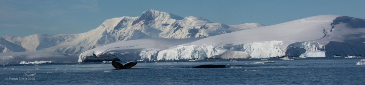
Next day I saw a group of Harp seals in the water. We were invited on a tour of the bridge. The Amundsen is only a few years old and has a beautifully modern bridge. The biggest ECDIS display that I have ever seen – still rendered next to useless by the clutter of chart overlays. Several radar including one that specialises in spotting sea ice. Not a wheel to be seen anywhere. Control is all done through joy sticks. Multi-beam echo sounder that could be deployed from a pod in the bow. This can give them 3D images of the sea floor but it has to be retracted to avoid damage in sea ice. Many other computer displays covering the engines, steering, and all the other ship functions. The master was clearly very proud of it all and happy to explain everything.
The afternoon saw the Amundsen at the entrance to the Bellot Straight. Back in the day, this was the key to the NWP. 25 km long and very narrow in places. The weather was a bit dull but still an improvement on the previous time we had been here when there was thick fog. With land close on either side it was an excellent opportunity for spotting wildlife. Right at the entrance to the channel we spotted a polar bear. First polar bear of the trip. Further on we saw two more and also a Musk Ox. To date I have not managed a good photograph of a Musk Ox and this is still the case. We had an early night to prepare for a 6am start at Prince Leopold Island.
Leaving Nome was the start of a long haul. North through the Bering Straits then east across the Beaufort Sea to the start of the North-West Passage. There are, I imagine, many interesting places to visit along the route but rules and regulations, as ever, get in the way. To land at any other places in Alaska we would need special permits and a pilot. The pilot would then need to fly back to Nome. All this is possible but extremely expensive. Trust me, if a Norwegian company turns round and says something is too expensive then it really is extortionately priced.
We crossed the international date line. Albeit briefly. This meant, technically, that we sailed into tomorrow and then came back again. Of course, the international dateline is purely imaginary. A cartographical convenience. So, what actually happened was absolutely nothing. However, if we had continued to sail west, if we went all the way round the world, then we would have lost a day. This happened to Magellan’s expedition of 1522 when they arrived at Cape Verde on Wednesday, 9 July 1522 (ship’s time) to discover that it was Thursday. Alaska used to belong to Russia and was considered to be west of the dateline until it was sold to the US. At the ceremony, 3:30 pm Saturday, 7th October 1867 it became Friday. At the same time the date jumped from the 7th to the 18th as they changed from the Julian calendar (Russia) to the Gregorian calendar (US).
Off Point Barrow we hove to for a few hours for helicopter operations. This is right at the top lefthand corner of Alaska where unfortunately someone that had joined in Nome became seriously ill and needed to be evacuated. It is not possible to land a helicopter on the Amundsen so the patient had to be winched from the top deck.
We sailed on past Prudhoe Bay, crossed into Canadian waters and eventually made landfall at Herchel Island. A rather grim and desolate place, this is where whalers used to overwinter their ships. Named by Franklin (the man who ate his boots) in 1826, the island became a haven for the large whaling ships of the late 19th century. By then, the Beaufort Sea was one of the last refuges of the extremely profitable Bowhead Whale. The Arctic whaling season was very short making over-wintering necessary. A small settlement was built although most sailors stayed onboard their vessels. Today the remains of some of the buildings are still there. The harbour area is under threat from rising sea levels. The main part of the island is endangered by coastal erosion (up to 3 m/year) and the melting permafrost causing active slumps.
On the next day we met the Nansen. This is the sister ship to Roald Amundsen named after the other famous Norwegian polar explorer Fridtjof Nansen. Built at the same time, the two ships look like identical twins. We paused for a few minutes, bow to bow, while everyone came out on deck to wave like demented gibbons. Nansen has just completed the Northwest Passage (NWP) and is heading west. We are going east and will shortly enter the NWP.
Cocktails with the captain
The following afternoon we passed north of Tuktoyaktuk, scene of our earlier adventures with a puncture. Unfortunately, we were so far offshore that we could see nothing. By the evening, we arrived at the Smoking Hills. I had noticed this on the itinerary but rather naively imagined it to be an island with clouds on it. What we actually found were genuine burning cliffs. The land was literally on fire. The fires result from autoignition of sulphur-rich lignite deposits says Wikipedia. Definitely one of the more remarkable sights either of us have ever seen. We cruised slowly along the cliffs allowing us to have a good look and take many photographs. Later I learned that typically the area is shrouded in fog and the smoking hills are barely visible. From the Smoking Hills we steamed north a little, rounded Cape Parry and set a course east in to the NWP proper.
Further on into the Gulf of Alaska, we came across the ruined village of Unga. A ghost town on the Aleutian Island also called Unga. This place was abandoned in the 60s but used to support a population of a hundred or so since the late 19th century. Fishing and a small mine were the primary sources of income. The weather was awful. Overcast, windy and raining in squally bursts. Diane was not in the slightest bit interested in getting wet, so I went ashore on my own. A few battered buildings are all that remain. Not the most exciting island I have ever landed on but, even so, it was a small, interesting island in a very remote place. I really liked that. Coming back on the RHIB we had to push into the wind and the waves. It was quite exciting but I got completely soaked and Diane was not impressed when I left wet patches on the cabin floor.
Heading even further west, out into the Bering Sea, we cleared the Aleutian Islands and reached the Unalaska Islands. The wind had become fierce and the ship was moving a lot. The Amundsen has a very sea-worthy hull. I like the way it moves. A steady and predictable rolling. Many of the ships I have sailed on crashed around in ways that inevitably surprised you and could easily catch you off balance. A considerable proportion of the passengers were far less enthusiastic about the how the ship rolled and had retreated to their cabins. Diane was starting to look a little green around the gills when we steamed into the calm waters of Dutch Harbour. Fortunately, motion sickness disappears very quickly once the movement disappears.
Dutch Harbor has been a busy centre of commerce for many years. As well as serving several major shipping routes, it also supports a sizeable fishing fleet. This is one of the richest fishing areas in the world. During WW2 the Japanese bombed the harbour. Along with Pearl Harbour it was one of the few places in the United States to be bombed by the Japanese. There is little war museum. When we arrived, it was packed with people from another cruise ship. When I say packed, what I mean is that the museum had reached its fifty-person capacity. We are not really museum people, so we moved on, bought some crisps in the supermarket and ended up in a bar. This was the magnificently named “Norwegian Rat Saloon”. Apparently named after rodents that first arrived in the town from a Norwegian trawler. Our new friends from the ship were here. Hello Francis and Clint. So, we settled down for a few beers and some chat with the locals. One oddity about Dutch Harbor is that although the area is famous for Red King Crab, it is rarely sold locally. They are only allowed to sell the crab once it has been sent off for cleaning and sanitising and packaging and taxing. It can then be shipped back to the island in impressive, shrink wrap packaging, but it is very expensive. However, if you did want to find locally caught crab that had maybe been removed from the system (not that I am suggesting there is a black market, but just in case) you might want to start at the Norwegian Rat Saloon.
Norwegian RatNomeSt Matthews
Pushing north-by-north-west way out into the Bering Sea we passed by St Paul Island. The weather was too bad for a landing. The ship was rolling again. There were not so many people in the bar in the evening. Fortunately, next day, the wind eased. We reached St. Matthew Island, the furthest point from human settlement in Alaska. This is a very rarely visited island. We felt quite privileged to be able to go ashore. Diane was not impressed by the rain and the sea state. The fog did not help. By the time we reached the shore, the Amundsen could no longer be seen. We pottered around on the beach for a while. I completely missed the opportunity to photograph the very rare McKay’s bunting. I saw a group of much better informed “bird nerds” gathered round a very boring looking white bird. I thought nothing much of it and plodded on in search of something more interesting. On the way back to ship we took a detour round a tall, bird covered rock. Here I took photographs of several types of bird new to me. Including Tufted Puffins which, like all puffins, are ridiculously cute.
Next morning we arrived in Nome. We are doing a long trip on the Amundsen. This is made up of a number of shorter trips that have been stitched together. We had just completed the first of these, Vancouver to Nome. This meant many people leaving the ship to go home. Then, later in the day, many more people arriving for the next leg, Nome to Halifax via the north-west passage. We stayed in our cabin while the chaos of disembarkation settled. Then we wandered into town. This is another of those wild west towns. Not very pretty but interesting. Nome is a gold town. There is still gold to be found. All the easily accessible gold is gone but there is still plenty in the gravel just offshore. People build their own boats with suction tubes and panning equipment. When the weather is good, they take these just a short way offshore. A diver handles the suction tube underwater while the gravel gets sifted and panned on the boat. I have no idea if there is still a good living to be made like this but there are certainly a lot of people giving it a go.
Gold prospecting boat
We got back to the ship early. The wind was picking up again and squalls of rain were making it unpleasant to be outside. The Amundsen was having problems staying moored. We watched from our little balcony as several mooring lines snapped. Down on the pier a group of workers were struggling to attach new ropes. The ship started up its main engines and then used these to push the vessel again the dock wall to hold it in place. We found out later that five of these massive, thick mooring lines got broken. I noticed an interesting safety feature. Each thick rope has a small central core that does not break. I guess that this is more elastic than the main rope. Possibly it is longer and coiled inside the central core. Whatever, because it does not break, it helps prevent the broken rope ends flying off dangerously. There is an awful lot of energy in the rope when it breaks. If it hits something, or someone, it can cause a lot of damage. This is one way to help mitigate the risk.
In the evening, the wind dropped, and we managed to get the rest of the passengers onboard. Next morning we had set a course westward. Deeper into the Bering Sea. Later we would turn north and navigate the Bering Straights between Russia and the United States. In the meantime there were whales. A lot of whales. I spent a very happy couple of hours on deck trying to photograph them.
The area around Kodiak Island was proving to be one of the highlights of this part of the trip. We were quite happy to stay there another day. In the evening there were whales and the next day, more bears.
Photographing whales can be a bit tricky. You see a spout, grab the camera, point it in the correct general direction and then get to photograph the splash as the whale disappears under the water. Humpbacks can be a little bit easier. They surface briefly after blowing and then flip their tails up before diving. This is just about enough time to get the camera onto the whale. This is also why most of my whale photographs are the tails of Humpbacks. Fortunately, it is often possible to identify a whale from its tail. This is what a group called HappyWhale do. They use the patterns on the fluke of a whale to identify it and then maintain a database of where and when each animal has been spotted. People can submit their photographs and then every time one of your whales gets spotted you get a notification. Meanwhile, the database is fast becoming a valuable resource for studying whale behaviour.
The next morning was spent in Geographic Harbour on the south side of Kodiak Island. The weather stayed good and the bears were numerous. We floated about in the RHIB keeping a good distance from the bears. The bears took very little notice of us and were generally very occupied with the business of catching salmon. All too soon it was time to leave. The RHIBs were stowed and we set off along the Aleutian Island chain.
The next day was entirely dedicated to watching wildlife. We were in the area around Kodiak Island some 500 km south-west of Anchorage. The weather was perfect and the wildlife was prolific. Bears everywhere.
Katmai National Park, opposite Kodiak Island, was first designated a national monument in 1918 to protect the area around the Novarupta volcano. This was formed during the eruption of 1912. The biggest eruption of the 20th century it created the Valley of Ten Thousand Smokes, a 100 km2 pyroclastic flow up to 200 m deep. The park hosts 18 volcanoes of which 7 have been active since 1900 including the centre-piece Katmai stratovolcano. Since the initial establishment of the park, it has become increasingly well known for its abundance of wildlife. This includes many brown bears that feed off the sockeye salmon.
Our first trip out in the morning was mostly about watching a single brown bear. This was at Kukak Bay in the Katmai National Park. He was catching salmon in one of the many small rivers emptying into the bay. Watching from the RHIBs seemed ideal. The animals took truly little notice of us so we could easily get quite close.
In the afternoon we went round to the other side of Kodiak Island. The island is big. Second largest in the United States and bigger than Cyprus. Two thirds of the island is designated as the Kodiak National Wildlife Refuge – home to the Kodiak bear and all five types of Pacific Ocean Salmon. We saw more bears there. Also, a Sitka deer, enormous star fish, a fox, loads of seals and a Bald Eagle with two youngsters.
Going further north we arrived at Icy Bay. The ship nosed its way into Tsaa Fjord and they launched the RHIBs. The Amundsen cannot sensibly drop anchor here because the water is too deep. Instead, they use a clever Dynamic Positioning (DP) system. Multiple GPS receivers are used to accurately determine the position and orientation of the vessel. The DP uses the ship propellers and bow thrusters to keep it in exactly the same place. In effect, they can just park the ship anywhere. We spent the afternoon pottering around in the RHIBs. A group of canoeists went out. There were no shore landings. I don’t think that is allowed here by the park rules.
Several glacier tongues drop down into Icy Bay making for a spectacular scene of ice and cliffs. The amount of meltwater was phenomenal. I have never seen anything like it. It is normal, in the summer, for meltwater to permeate through the glaciers and run out at the bottom. In Svalbard, we explored an ice cave that was made in just this way. Here, there were thundering great torrents of water coming out from under the ice. It was impressive and noisy. Huge waterfalls were gushing out. The water was heavily sediment laden making it a dirty grey colour.
The next day we continued making our way north along the Alaskan panhandle. Wonderful little islands and small settlements. We passed many more glaciers and at one point, paused to watch a distant bear on the shore.
Wrangell (pop ~2,000) was founded by the Russians in 1834 when they built a fort. This makes it one of the oldest non-native settlements in Alaska. The British Hudson Bay Company leased the fort and eventually Wrangell became American when the United States bought Alaska from Russia in 1867. Today the main industries are fishing, logging and tourism. Wrangell is close to the River Stikine delta. The Stikine is a major river flowing from British Columbia. Historically, it has always been important for fishing, hunting and trade. Now it is also important for tourism and as a recreational area.
We joined a group in a jet boat to explore part of the river. The boat was very fast and also very noisy. Talking was near enough impossible. So, the day was made up of short, relatively peaceful intervals in between high-speed dashes along the river. We travelled through the delta and then a short way up the main river. A left turn took us onto Shakes Slough, a tributary. We followed this all the way up to a Shakes Lake which ended at a glacier.
There was some wildlife on the route. Mostly birds. We got quite close to a pair of Bald Eagles. One was guarding a nest while the other was eating by the river. We also came across a government boat measuring fish. Fishing is tightly controlled after several incidents of overfishing nearly wiped out the salmon completely.
Not a jet boatFish measuring
In the lower reaches of the river, we came across several houses that were floating. Not house boats but normal looking wooden houses built on floating pontoons. For some reason, the river and the surrounding land are managed by different authorities. Locals are not allowed to build weekend accommodation on land but they can have a semi-permanent structure if it is floating.
Arriving at the lake, we drifted right up close the glacier and enjoyed some wine and snacks. A cool breeze coming off the ice made it at least ten degrees colder than back down at the delta. Twenty minutes later we began the trip back down. This seemed faster than ever. This time we were not stopping for sightseeing. My ears were ringing by the time we got back to the dock.
Big, bustling, busy, modern, shiny. In many ways Vancouver is everything that the rest of Canada, at least the part that we saw, is not. The taxi dropped us off at the towering tribute to glass that was our hotel. All very contemporary, efficient and soulless. Our room was on the 26th floor. Nowhere near the top of the hotel but plenty high enough for a good view and to make stepping onto the balcony slightly unnerving. We had a couple of nights here while we waited for the Hurtigruten vessel, the MS Roald Amundsen to arrive. On this ship we plan to literally sail from one end of the planet to the other. Our route initially goes north up the coast of Alaska and then east through the Northwest Passage that we did part of last year. Greenland then south along the eastern seaboard of the USA. Mexico, the Caribbean, through the Panama Canal and then south again past Ecuador, Peru and Chile. Finally, south through Drake’s Passage to the Antarctic Peninsula. Long trip. Over ninety days on board. We are looking forward to it immensely.
We had a couple of days to kill in Vancouver. I wasn’t feeling too great so mostly we just lazed around a bit. The Hurtigruten people arrived and after an early breakfast they took us on a coach tour of the city. This confirmed, to me anyhow, that we were not missing very much. The tour ended at the pier where we needed to go through security and passport control before joining the ship. We went through two sets of controls. One to do with leaving Canada and joining the ship, the other to do with entering Alaska -where we would be by the next time we got off the ship. Took a while but we made it. Nothing got confiscated, our documents were in order. I felt quite pleased. Mid-afternoon we arrived at our cabin.
There was a seagull sat on the balcony railing giving me the eye. I took my camera out and opened the door. It still did not move. I photographed it. A couple of times. The bird stretched its neck a bit and then did an enormous dump on the wooden rail before taking off and banking down, out of view. I was left with a nice, close-up photograph and a big bird shit.
The cabin is great. Small but well thought out. The bathroom, in particular, is very well designed. And we have a little balcony. When I chose the cabin, I deliberately went for one on the starboard side. Most of this trip we will be heading south. Diane and I are not morning people, so we don’t care about the sunrise to port. The starboard side sunset however might, on occasion, be worth sitting outside for. There may even be the odd sundowner cocktail. We are here for 94 days. Plenty of time for pictures of the cabin later.
Late afternoon we sailed. Setting off on a voyage is something I always find exciting. This one especially so. Vancouver is a working port as well as a tourist destination. As we moved out, we could see the arrays of cranes for cargo handling, bulk loaders and the other machinery of a modern dock. There was an immense pile of sulphur. This intrigued me. Surely it is an immense fire risk. In my youthful experimentation to try and create gunpowder, I managed to burn quite a lot of sulphur. It gives off some seriously nasty fumes. Definitely not the sort of thing you should do in your bedroom. I also wondered about what would happen when the rain came.
We slipped north past Vancouver Island through Queen Charlotte Sound and then into the Canadian Inside Passage where whales were spotted. I managed to catch one jumping out of the water. It is not a very good photograph but as an omen, in just the first couple of hours of our voyage, it was wonderfully auspicious.
Next day we arrived at Misty Fjords National Monument. This is a protected wilderness area famous for steep cliffs, deep fjords, coastal rainforest, glacier-carved valleys, and unique geological features like old lava flows and mineral springs. There are two common activities that guests on the Amundsen are invited to partake in: shore landings and boat cruising. Both involve the small fleet of RHIBs that the ship carries. Each is piloted by an experienced and qualified boatman. They are deployed by davit from large side door in the hull. Passengers are assigned to groups and invited, one group at a time, to the rather gloriously titled Expedition Lauch room. Here we get to board a RHIB through another side door and a docking platform. Typically, there are ten passengers to a RHIB. In the small boat we get to potter round the area for an hour or more. This is a great way to see some places, take a few photographs and generally get to experience an area.
The night after we finished the Dempster, we camped at Pelly Crossing. The council provide the campsite here, it is very pleasant, spacious and free. In the morning, we discovered a flat rear tyre. Very flat. The small electric pump we had bought in Inuvik was no use for this. I called Canadream to ask where the tools were and they told me not to attempt to change the wheel myself. I explained I was quite capable and willing but no, do not even think about it. What would happen, they said, if something went wrong further down the road as a consequence of me changing the wheel? Mid-afternoon a man arrived. Jacked the car up. Fitted the spare and then left. We could then press on to Whitehorse – nearest place with a tyre shop. In the morning, we arrived at the appointed tyre shop where they discovered that six of the eight wheels nuts were loose. Worse, the holes in the spare wheel were now oval shaped because of the way the wheel had been rattling around. We had only narrowly missed a nasty mishap because the spare wheel was on the verge of coming off. Now, we no longer had a usable spare wheel. Two days later, Canadream had us visiting a scrap yard to collect another wheel and then another tyre shop to fit the spare tyre to it. All this because they would not trust me to use a spanner.
Between punctures and the Dempster, we were running on a tight schedule now. We passed more forest fires. Some of them still burning. Also, areas where there had been fires in previous years. We could see how the forest was starting to grow back.
At 2.6 km2, Carcross desert is possibly one of the smallest deserts in the world. It is not really a desert, just a few sand dunes. The sand was formed during the last glacial period as sediment on a lake bottom. When the lake dried up the dunes were left and vegetation locked them into place. The dunes support some rare plants. The government tried to make it a protected area a few years ago but the locals objected because they like to use the dunes for sandboarding (like snowboarding but on sand).
We saw some more bears and managed to photograph one. Usually what happens is that we see a bear, stop the car and the bear vanishes into the forest. This is good bear behaviour. It is better all-round if bears are shy of humans. It is when they lose their nervousness and start getting too close to humans that they can become a problem – and that just leads to them being shot.
The rest of the route back to Vancouver was easy. Easy roads and comfortable campsites. We came through Whistler which is a big ski area. Unfortunately, there was not any time to explore. We found a monster car wash at one campsite. This was a lucky break because we had a lot of mud to remove. Even with both of us working at cleaning, it took most of the morning to get the RV back into a reasonable condition. Then most of the afternoon to clean out the inside and pack our stuff. We were quite pleased with the results and thought that the 10,000 km we had done did not really show. If the vehicle needs a lot of cleaning when you hand it back the company will charge quite a lot for this. The next day we dropped the RV off, picked up our bags and headed into Vancouver.
The Dempster Highway starts just south of Dawson City and runs north-east for 736 km to the Arctic Ocean at Tuktoyaktuk. It is mostly a dirt track and build on permafrost. To stop the permafrost melting there is an insulating layer of gravel up to 2.5 m deep. The first 115 km were built in the early sixties when there was a suspicion of oil to be found. The rest was built in the late seventies in response to the Americans finding oil in Prudhoe Bay. The road is quite well maintained. We saw several graders working. There is also significant traffic including large trucks.
Yukon River
As we set off, it was raining, again. The sky was grey and the road slippery. I was grateful we had 4WD. Muddy spray off the road coated the back of the truck and before long the lights and numberplate were quite indistinguishable. Despite the damp, the driving was quite fun. Just this one, long track winding its way through the wilderness. We passed a vehicle coming the other way every ten minutes or so. The first section is through dense forest. Then you start to climb up into some hills and the terrain becomes more open. Dropping down again we started following a series of river systems. The Blackstone River and then over to the Ogilvie River by way of Engineer Creek. The confluence was marked by the muddy waters of Engineer Creek swirling into the clear, dark waters of the larger Ogilvie River. Some of the tributaries had bright red rocks along the banks. I think this is caused by iron ore that is leaching out of the surrounding hills. We crossed the Arctic Circle as indicated by roadside sign.
The weather started to clear and while I don’t think it actually got as far as sunny, it did get a lot brighter. Drier weather brings its own problems though. First of all, there is the dust. In some ways not as unpleasant as mud spray but it has a remarkable ability to penetrate. Our plastic living unit ended up full of the stuff. We needed to shake the sheets out before we went to bed. The other problem is the mosquitoes. There are several basic campsites along the Dempster and come early evening, we stopped at one of these. Looked lovely until I opened the door and was met by a great cloud of mosquitoes rising up out of the grass. It did not need a second glance for me to shut the door and keep driving. Towards the border between Yukon and North West Territories (NWT), the road cuts through some bare mountains. We stopped on a pass where there was plenty of wind to keep the mosquitoes away and were entertained by a family of ground squirrels. They were running around being terribly busy. I think they were collecting nest material. Not really sure, but great fun to watch.
Next day we arrived at the ferry across the Peel River. By contrast to the previous day, it was sunny and warm. Mid-twenties. Probably as hot as it gets. The mosquitoes were making the best of it. Not just mosquitoes but also a large variety of that bite you in a large variety of ways. I noticed some birds had been building nests underneath the bridge of the ferry. This made sense given that, at these latitudes, there are very few trees and the insects that the birds eat seemed to really enjoy feasting on ferry passengers.
A short while later came the ferry across the Mackenzie River. Same arrangement. Free, government run ferry in the summer and an ice bridge in the winter. There then followed a very long, flat section until we arrived at the town of Inuvik. This is quite a modern, bustling place with gas stations, supermarkets and a shopping centre. We only paused briefly before pushing on to Tuktoyaktuk, a much smaller village on the edge of the Arctic Ocean that marks the northern limit of the Dempster Highway. This last section of the highway loops around numerous lakes that form the Mackenzie River Delta. As we drove into town, we noticed that many people had mosquito nets over their heads. This was a worrying sight. We found the tourist office and were directed to the campsite right at the end of the village overlooking the sea. A dozen or so other vehicles were there. It is not much of a campsite and the toilets are some of the most evil I have encountered in a while. But we were happy to have made it to the Arctic Ocean. A stiff sea breeze kept the flying insects and the smell from the toilets at bay.
Ibyuk Pingo
Next day began with a puncture. Fortunately, it was only slow. We found a garage to get the tyre pumped up and then headed back to Inuvik in the hope of getting it repaired. Before that, we wanted to check out the Pingo we had spotted when we arrived. We saw one in Svalbard earlier in the year. Pingos are intrapermafrost ice-cored hills, 3–70 m high and 30–1,000 m in diameter. They are typically conical in shape and grow and persist only in permafrost environments. Worldwide there are only about 11,000 pingos of which over 10% are in the Tuktoyaktuk area. There are a couple of mechanisms by which they are created. Both of these involve a core of frozen water which, over time, pushes the hill upwards. The Pingo was a pleasing shape and came with a notice board explaining how it had been formed. We were looking at Ibyuk, the largest pingo in Canada and the second largest in the world.
It was a Saturday and nobody was working. After determining that there were only two possible tyre shops we resigned ourselves to staying for a bit longer. At the small shopping mall, I managed to buy a small electric tyre inflator. This would at least buy us some more time. Fortunately, the campsite at Inuvik is lovely. Probably the best toilets in NWT and hot showers as well.
Sunday afternoon seemed unlikely for tyre repairs but we tried Polar Tyres anyhow. The man was in. He emerged from behind a fishing boat on a trailer. His arms were literally covered in blood up to his shoulders. Momentarily, I wondered if we had just stumbled on some hideous criminal activity. He explained that, with his brother, they had just been out harvesting Beluga whales. Now they were cutting them up for the freezer. Just occasionally when I am travelling something gives me the feeling of being a long way from home. This was one of them. We arranged to get the tyre repaired in the morning.
After three nights at the top of the Dempster we were properly back on the road again. The return trip was a simple unwinding of the trip up. The weather got damper again as we returned to the land of trees. We eventually arrived on the Yukon Highway in just the same sort of downpour as when we had left.
The river ferry at Dawson City operates 24 hours a day. In the winter, the river freezes and traffic drives on the ice. The ferry is paid for by the government. There is no booking, no reservations. You just turn up and wait until you can get on. It takes less than ten minutes to cross the river and this brings you to the start of the Top of the World Highway. This is mostly a dirt track and gains its name from the way the road links the top of several hills such that for most of the route you are looking down into valleys. It is 127 km long and only open in the summer.
At about the highest point of the road, 100 km in, you arrive at the USA border. Previously, we had both applied for ETAC (Electronic Travel something or other) but we still needed to be finger printed and photographed before we could be allowed in. In my experience, border guards do not have a sense of humour. Never. Not even a hint. Surgically removed or something. Trying to joke with a border guard is like trying to play tennis with a jelly fish. It just won’t work. This time however, I was standing in front of the camera with my best serious but clearly innocent face when the guard told me I could smile. I was taken aback. Passport photographs are strictly no-smile zones. But, as the guard went on to explain, this was America, land of the free, where you can do anything. He then told us that Independence Day (July 4th) was the one day of the year that English were not allowed into USA. He then went on to regale us with stories of bear hunting, the bear steak he’d had for breakfast and what to do if a bear came in the door. I suggested running away but no, he was clear that he would stare it down. I pointed out that my apparent lack of bravery was because he was carrying an exceptionally large revolver whereas I was armed with only a smile. Never saw the final ID photograph but I suspect I mostly looked puzzled.
Top of the WorldAlaska
Just round the corner from the border post is an immense “Welcome to Alska” sign and our first view across the Alaskan scenery. A few miles further on the road descends through a valley system and comes out at the gloriously named town of Chicken. They appear enormously proud of the name and just about every signpost has a chicken theme. We also saw a moose. It stepped into the woods and disappeared long before I could get my camera out. They do that. Very frustrating animals to try and photograph. Remarkable how, despite their size, they seem able to completely vanish in just a few steps.
The weather was consistently terrible. Rain and thick grey clouds and fog, several types of mist and more rain. We seemed to spend quite a lot of time driving without seeing very much. Arriving at Fairbanks, we turned south towards Anchorage. I would have liked to go north here, to Prudoe Bay and the Arctic Ocean, but the hire company had put the Dalton Highway out of bounds. Instead, we went through the Denali National Park where we drove past the highest mountain in North America without seeing even a hint of it. At Wasilla, we began heading east back towards Canada and at last the clouds lifted a little so we could see the mountains and glaciers of Chugach National Park.
We completed our soggy circuit of Alaska at Tok quite a few days earlier than planned. We might have taken a leisurely drive back to Vancouver but instead decided to try another route to the Arctic Ocean along the Dempster Highway in Yukon. By late afternoon we were back on the Top of the World Highway and the road to Dawson City.
From Dawson Creek we had been following the Alaska Highway. This was built in the second world war to connect Alaska to the rest of the USA as part of a response to the Japanese threat. Back in the day it was a dirt track and considered to be a long, difficult and, in places, dangerous route. These days it is a fast, easy road supporting a lot of traffic. I reckoned that well over half the vehicles we saw were RVs. Many of these are American so that means an RV based on a full-sized coach towing a family car. The Canadians tend to favour an equally large RV that is towed by a pick-up truck using a fifth wheel bolted into the flat bed. The rest of the traffic is commercial trucks often pulling two full sized trailers.
At Watson Lake we left the Alaska Highway and headed up the far less travelled Robert Campbell Highway. This took us north, roughly following the Pelly River and deep into Yukon. A few short sections of this route are sealed but most of it is a dirt track. Throughout the rest of the afternoon, we only saw two more vehicles. We enjoyed two quiet days on quiet roads with quiet campsites. Rather disappointingly we saw very little wildlife. We had hoped there might be more on a quieter road but obviously this is not always the case. At Carmacks, we joined the Klondike Highway which would take us north to Dawson City. We also followed the Yukon River for a short while. At the height of the Klondike gold rush Dawson City had a population of over 16,000. Much of the food and supplies needed to support so many people came in on paddle steamers that navigated their way up and down the Yukon River. Today Dawson City is a tenth the size and there is a well-made road.
North from Pelly Crossing we passed through a large area of forest fires. The air still smelled smoky and we drove past several miles of blackened trees. A few days earlier the road had been closed. Canada experiences a lot of forest fires in the summer. Most of these have a natural cause and are so far away as to not cause many problems. Occasionally fires are caused by negligence. These are often much more of a problem because they are usually closer to habited areas. There is some suggestion that climate change is exacerbating the situation. In the last few years there have been some quite extreme heatwaves leaving the forests tinder dry.
Dawson City still manages to feel like a bit of a frontier town. Some of the shop fronts and wooden buildings have been deliberately left looking a little like a wild west film set. There is an old paddle steamer by the side of the road and pretty much every sign appears to reference gold. We stocked up on a few essentials and prepared ourselves for the ferry in the morning.
From Banff we got a shuttle to Calgary where we collected our Recreation Vehicle (RV) for the next few weeks. This came from the Canadream company, who appear to have a virtual monopoly on Canadian RV hire. We dealt with them last year and it all worked out well. So we came back. This time however, the RV we chose was a bit more rugged. Essentially it is a plastic box, the living unit, on the back of a standard 4×4 pickup truck. A Ford F350 with a 6.7l powerstroke diesel engine. The complete unit is a bit cosy but we could take it down a few dirt tracks. Initial leg of the trip, to Watson Lake, is all sealed roads, easy.
The first thing we did was drive to the local supermarket and buy a load of food and wine. Also, some of the stuff we wanted in the RV that is not normally supplied. A sharp knife and cutting board, small food processor, fire-lighters, mosquito coils, extra bedding and so on. Then the vehicle would not start. It uses keyless ignition. I am always a bit suspicious of this. You have to close the door, put your foot on the service brake, select Park, make sure the key hob is close enough (to something), press the button and hope. Nothing happened. It was a bit embarrassing. I imagined that there was some part of the arcane starting spell that I was doing wrong. So, I was sure that when the spotty youth turned up to help us, that he would do something simple while making vaguely condescending remarks and the engine would burst into life. It was gratifying, in an odd way, that he was not spotty, or condescending and he could not start the engine. None of this helped solve the problem but it did make me feel better. Eventually it was decided that our almost brand new 4×4 Ford F360 was broken and would have to go back to Ford.
A replacement vehicle was found. A blue truck that looked almost identical to the original red one. I was however assured, that being blue, it would be slightly faster. An hour later we had moved all our gear into the new RV and set off into the evening traffic. Fortunately, it was not far to the campsite. I had planned that we should not have far to drive and also that we would stay there for a couple of nights. It is at least a day’s work to get all our gear organised in the truck. There is not much space so you need to think about what goes where quite carefully. Getting this bit wrong can easily lead to arguments further down the road. The few things that we don’t need for this part of the trip go in the small case. The one we use as hand luggage on a plane. This fits inside the medium sized case which in turn goes into the big suitcase. I think this is quite clever and it saves a lot of space.
A couple of days later, we were ready to set off properly. There are not many roads in Canada. This is especially true around the Rocky Mountains. Our plan, approximately, was to drive north up the eastern side of the Rockies to Alaska and then back down on the western side. Travel by motorhome is easy in Canada. For many it is by far the best way to travel. Campsites are abundant and, once you are away from the city, booking is rarely needed. Facilities range from full-service (water, sewage, electricity) to, well, nothing really. For $20 on a national park campsite you get a pitch in the woods with a table, firepit and firewood.
On the very first day we set off properly, we saw a bear. Not a glimpse of a bear in the woods but a full-grown black bear just ambling down the road. We had stopped for second breakfast in a layby and he wandered down the far side of the road. Caused a big queue of traffic. A short while later he had his fill of attention, hopped up the bank and vanished into the woods.
MooseMountain Sheep
One aspect of travelling that I love is the serendipitous way that things can happen. A few days later, a Saturday, we arrived at the Liard River Hot Springs Park. This is a very popular area and the campsite was full. It was the only time in the whole trip that we found a full campsite. They suggested we could camp in the car park across the road and walk over to use the campsite facilities. This did not impress us much so, despite the late hour, we pushed on. In the next half hour we saw our second bear, a whole heard of bison and moose with a calf. Brilliant. We then found a lovely little quiet campsite close to a remarkable waterfall.
BisonBaby Bison
Our route followed the Liard River as it wound north and west until we arrived at Watson Lake. This is a small town whose only claim to fame appears to be a strange forest of signs. A bunch of poles that visitors have been nailing stolen road signs to. For us it was significant because here we would leave the main road and strike off on to what we hoped was a slightly more remote and adventurous road.
The Rocky Mountaineer train company operate tourist trains along four routes mostly from Vancouver. This is train travel for its own sake. It is not a good way to get around because it is expensive and does not run to schedule. The passenger trains have to give way to freight trains so on each leg of the journey you can never be quite sure when you will arrive. It is intended to be a train where you can relax and enjoy the scenery while being wined and dined. There are two classes of comfort. In Gold you get an upstairs viewing area where you spend most of your time in your seat watching the world go past and being served drinks. Downstairs is a dining area where lunch and diner are served. The Silver class is more basic and food is served at the seat.
This all sounded quite fun, so at 6am we were sat in the lobby of a Vancouver hotel waiting for a transfer to the station. One thing they did not tell us about this two day trip to Banff was that it would involve some very early mornings. Our luggage was whisked away on a truck while we travelled by bus to the station. Here we were literally given the red carpet treatment as we boarded the train. The train trundled out of Vancouver. Then we were served breakfast and at around 10am the free bar opened.
The first part of the journey, out though the suburbs of Vancouver was only mildly interesting. As the morning rolled on the scenery began to open out and we passed through forests and hills. An early highlight was a black bear trotting through a field by the track. Free drinks all day sounds like a recipe for a wild party but the reality was that drinks were served at your seat and the service was very slow. We did of course thoroughly enjoy having another glass of wine put in front of us every so often. The food was heavily meat/fish orientated. The vegetarian fare felt like an afterthought. Too many times there appears to be an assumption that vegetarians prefer their food completely bland and lacking in texture. There was plenty enough to eat and snacks so we did not go hungry.
A big selling point of this trip is the scenery. The route through the Rocky Mountains is certainly interesting but in a gentle, peaceful way. None of the excitement that you can get with some of the world’s great train journeys. There were a lot of trees. If you don’t like tress then don’t come to Canada. The crew in the car told us stories about the different places we were passing through. This was done in quite an informative and interesting way. Definitely added to the trip. The seats were very good too. Large and comfortable. To Diane’s delight she found that the seats were heated via a little control panel by the arm.
We arrived in Kamloops quite late. By the time we were dropped of at our hotel it was well after 9pm. We had to be up again at 5pm. It is hard work being a tourist sometimes. We skipped dinner and went straight to bed. A nice touch was that our luggage had been delivered to our room We could leave it there for collection in the morning as well.
Next morning I probably did not wake up until halfway through breakfast on the train. That was only just before the bar opened. The countryside was becoming more mountainous. Occasionally we could see snowy peaks. We also saw several freight trains. Seriously long trains of tankers, shipping containers stacked two high or open cars containing loose gravel, sand, cement or sulphur. Apparently the top surface of these is sprayed with some sort of plastic which seals them against the weather and stops the contents simply blowing away. Day two was a lot like day one. Pleasant rather than exciting. A brown bear and two bald eagles later we arrived in Banff. This was the end of the line for us. We got to the Banff Inn quite late again and then set about preparing for the next phase of our Canadian trip
Last year we spent a couple of weeks in Iceland. Fabulous trip but we missed out on seeing an active volcano because it had stopped erupting a couple of weeks before we arrived. Now we had the opportunity. We were on our way to Canada and flying via Reykjavik. This is quite a cost-effective route. So, we arranged to stop over for a few nights. Our accommodation was the Viking Hotel in Hafnarfjordur, a little way outside Reyjavik. This is an interesting hotel. Quite comfortable and reasonably priced. It is also great fun if you have any interest in Vikings. Some of my Danish friends, who claim direct descendance from the berserkers of a thousand years ago, would undoubtedly relish this place and bring their own axes.
Our helicopter trip for the next day got pushed back a day because of uncertainty about the weather. Instead, we tried booking on a whale watching trip for the next day but this was cancelled because it was too windy. Such things are not an unusual occurrence, and the company were very good about refunding our money. Later that day we met up with Jón, our pilot friend from Iceland. He showed us round a few interesting places local to Reykjavik. We ended up having a pleasant meal in a restaurant overlooking a bay with a beach.
Next afternoon we all met up at the Reykjavík Helicopters office at the city airport. This is not Keflavík International Airport, located around 40km southwest of Reykjavík, but a much smaller facility just south of the city centre. Once again, our pilot was the very cool Solveig flying an Airbus H125. We felt safe hands. If you are going to fly around an active volcano then you really should pick a good pilot.
Fagradalsfjall is a an active tuya volcano volcano formed in the last glacial period on the Reykjanes Peninsula to the south of Reykjavík. Tuya are created when a volcano emerges through an ice sheet. They typically have steep sides and flattened tops. After sleeping for 815 years, it burst into life in 2021 and has erupted every year since. Being close to Reykjavík it has become a bit of a tourist attraction. Walking there will take four or five hours. This is a problematic way to see the volcano. Apart from the long walk, it is difficult to get anywhere for an unobstructed view and there are dangers. The current eruption is emitting a variety of poisonous gases so a sudden change in wind could cause a lot of problems. The broad valley where all recent activity has occurred is completely uninhabited and considered extremely dangerous. New erupting fissures and craters can open up anywhere without any notice. Much better then is the helicopter approach.
After a briefing we took off and tracked along the coast for a short way. An old volcanic cone acts as marker for the route. Helicopters fly out on one side of it and back on the other. A roundabout for aircraft. Getting closer to Fagradalsfjall you can see vast expanses of black lava. The remains of flows that have cooled. We spotted a place where a large bank has been built to try and control an earlier flow. These have been used quite successfully at times. If you are lucky the initial lava flow cools along the levee, cools and reinforces it. Sometimes it just gets washed away.
We headed straight for where the smoke was rising and then circled around the cone. From our perfect vantage point, we could see directly down at the boiling lava. It is a quite incredible thing to see rock boiling up close and personal. The lava boiled like a cauldron of thick porridge, spitting red hot gobs of molten rock into the air. A thick, viscous and slowly moving river of lava moved down one side. Absolutely fascinating to watch. We spent quite a few minutes there. I wished it could have been longer. Then we circled round the eruption site of the last two years and then, to my surprise, we landed.
Solveig put us down on a reasonably flat area of lava flow. Amazing. We landed on some of the newest rock in the world. It was still warm and smoke was rising through cracks. Sulphur collected on the edges of the rock and the air smelt of fire and brimstone. We were somewhere that Dante might have recognised. The rotor blades slowed to a halt and we got out for a wander round. Very strange place. It was quite a privilege just to be in such an unusual place. Just a few years ago it simply did not exist. I did wonder a little about safety. Was it possible that the ground could just give way and drop us into a fiery pool of lava? An immense eruption was busily going on not far from us. The rock seemed solid enough. After a few hesitant steps I decided it was probably alright and tried to look casual as I walked away from the aircraft.
After photographs and some time pondering, we clambered back on board for the short flight back. Quite an amazing experience. It is difficult to do justice to describing things like this without sounding all flowery. I am not a natural writer. Look and the pictures instead. Jón drove us out to a picturesque park and light house. Here we could reflect on the experience while looking at the many ducklings.
In the morning, we continued our journey to Canada. The aircraft was a bit cramped but this is not such a long haul and we did get some amazing views over Greenland.
We thoroughly enjoyed our time sledging with the dogs but so far as practical travelling is concerned, dog sleds are a relic of another age. These days, if you want to get around in snowy places then a snowmobile, or ski-doo, is the tool of choice. Longyearbyn is stuffed to bursting with them. Back when I worked in Antarctica, the snowmobiles were quite basic. The manual pull-cord made them energetic to start, exhausting at times. They were awkward to steer, slow, noisy and uncomfortable. All this with the great smell of two stroke oil. The modern machine has a powerful four-stroke engine with an electric starter, full suspension, soft seats and heated handlebars. The sitting position and technology have some similarities to a motorbike but otherwise there is surprisingly little in the comparison. Riding a motorbike requires a level of precision and balance. The snow mobile however, just launches off across the snow bouncing and skittering around while heading in only the general direction that you point it. None the less this is great fun. You can easily reach speeds of 50 km/h or more which feels much faster and can be remarkably exhilarating in a sort of hanging on to a wild rampaging beast sort of way.
Our first trip out was north to the top of some cliffs overlooking Tempelfjorden. We each had our own snowmobile and were part of a group of ten riders. The day began with a briefing and introduction to the machines. We got togged up in warm, one-piece suits, mitts and a helmet before walking down a short slope to where the snowmobiles were all ready for us. The group leader was towing a small sledge with safety equipment. He we also equipped with a rifle and a flare gun in case of polar bears. We never got to see any bears on Svalbard but we were regularly assured that there are plenty around. Travelling single file, we set off along some very dirty and well used snow up the main valley. After about fifteen minutes we took a left and headed up into the mountains. Soon we had left all traces of civilisation behind. Just us, the snow, the mountains and the odd reindeer. Over the course of a couple of hours we followed a series of linked valleys until eventually emerging at the top of the cliffs. The view was spectacular. A wide-open stretch of sea with mountains at the far side and a glacier in the distance. Coffee and biscuits appeared from the survival sledge and we spent a good twenty minutes just taking in the scenery and watching a few sea birds. The journey back was uneventful but still great fun. Everyone was getting a bit more comfortable on the snowmobiles so we could pick up the pace a bit.
The next day we went down a mine. Svalbard was a very quiet place for just a handful of trappers and whalers until the start of the 20th century. Coal was discovered and the mining companies moved in. For while the archipelago was all about mining. Some of the best quality coal in world could be mined here. Mostly found in horizontal seams that were accessed by drift mines cut straight into the valley walls. Today all but one of the Norwegian mines are closed and the last of the Russian mines has almost stopped production. Tourism is the main industry now so quite reasonably, one of the old mines has been turned into a museum. This is not the sort of museum with glass cased displays and little information cards, it is a mine where they stopped working a few years ago. The passages have been made safe, or at least safer, but otherwise things are pretty much as they were on the day production stopped. It is quite dirty inside. We were given overalls to wear and headtorches, so the small group soon started to look like miners. After looking around the workshops and the topside coal handling facilities, we were led down one of the main passages. The coal seam was about two feet thick. From the access passage, the miners would dig into this with coal cutting machines creating a narrow crawl way which was supported by multiple props jacked into the roof. Then they would cut another segment of the seam next to it and then another. Imagine trying to remove the cream layer from the centre of a cake by cutting successive pencil shaped pieces out and working your way across the cake. By the fourth cut they would need to start removing the props from the original cut otherwise they would run out of props. This was the dangerous part because the roof would eventually collapse once enough props were removed. The trick was to not be there when this happened. Apparently, the skilled miners could listen to noise the mountain made as they took the props out and tell from this when it was becoming unsafe. I crawled into one of these seams, hand and knees for about 100m, to get a feel for what it was like. I left with a whole new level of respect for the bravery of miners. And with much coal dust firmly embedded under my finger nails and many other places.
On our last day we took another, longer, trip on snow mobiles. Different company but the basics, a briefing, clothing and the machines, were similar. One major difference, when we set off, was the light was very flat. When the sky is completely clouded over there are no shadows and it can become difficult to judge the lie of the snow-covered land. It all just looks white and a bit featureless. These conditions can be tricky skiing and on a snowmobile because it is hard to anticipate how the land is sloping and changing. We set off a lot faster than the previous trip and I found I had to really concentrate. Diane had chosen to ride pillion with me and this made balancing a little more difficult. For the first hour I think all I did was focus on the snow mobile in front of me, watching to see the shape of the hills and the valleys. Later, as the sun started to break through, it became much easier and far less disconcerting.
We drove eastwards for a good couple of hours before dropping down into a wide valley. At first, I thought this might be a frozen lake. It looked like one, but fact was just a flat and safe valley bottom. Across at the far side of the valley we followed another small valley before emerging at the coast by a hunter’s lodge. Over coffee and biscuits, we were told tales of the trapper that lived there for most of his life along with his wife. The route back involved a short stop at a gully which was fun to climb up and slide back down. We also went up to the top of hill for some lovely views.
Getting up at 4am next day for the flight was not much fun. At Tromsø , everyone needed to leave the plane, with their luggage. We then went through security and passport control to re-enter Schengen before getting back onto the same plane, in the same seats, with the same luggage. I found someone had taken the overhead space that my luggage had previously occupied. Somehow this seemed rather rude. Back in Oslo we collected the car and over the next few days made our way back to the UK.
We had signed up for a three-day dog trip. Next morning, we were standing outside the Coal Miners Cabin, again, waiting to be picked up. Marcel, our guide, met us in a rather battered van then we collected the two other couples doing the trip. There are only a handful of hotels in Longyearbyen and it seems to be normal that excursions include hotel transfers. A couple of miles outside of town we arrived at the dog kennels. The dogs were already keen and excited. Each dog has its own kennel and is chained up so that it cannot quite get to any of the dogs around it. They jumped up and barked a lot. Small when compared to the Greenlandic dogs we met a few months ago. Maybe 25 kg max. They are a cross between several breeds including Greenlandic and Serbian Huskies. Somewhat to my surprise, they were very friendly to humans. Sledge dogs are not pets, they are work dogs and can sometimes be a bit aggressive. These dogs, however, were clearly well acclimatised to being handled.
First job was to get changed into warm padded overalls and insulated boots. Then we had a short briefing about dogs and sledges. Then we were shown how to harness the dogs. The main thing is to keep hold of the dog. They are so excited that if you let one slip it will run off. It will come back eventually but only once it has run round the other dogs, started a few fights and generally caused mischief. Best to hang on to them. Diane and I had our own team of six dogs. Each had its place in front of the sledge. The harness fits around the dog’s shoulders so you must help them step into it. Then there is webbing to help even out the load and fit comfortably across the back. From the front of the sledge there is a long gangline, the cable that all the dogs are attached to. A tugline connects the rear of the dog harness to the gangline. This is what takes the load when the dogs are running. A neckline is attached from the dog’s collar to the gangline. This does not take and load but helps keeps the dog organised.
In much less than an hour we were all ready to go. Marcel set off with his team. We were next. Diane sat on the sledge and I stood on the back to control the brake. One of the helpers released the rope at the back of the sledge and we were off. The only control I had was the brake. A claw like affair at the rear of the sledge that you variously stand on or even jump on to control the speed. The dogs simply followed Marcel’s sledge. I did not really have any control over that.
We started off easy. A flat, wide trail that led up a shallow valley and back down the other side. In the thirty minutes it took to do this the dogs settled down a bit, we settled down a bit, everything started to get a bit easier. Then we turned eastwards and set off for a cabin somewhere in the mountains. Both of us started to get into the rhythm of dog sledding, which is really rather lovely. It is very quiet compared to snowmobile. The dogs trot along happily. They really are happy; it is easy to tell that they just love pulling the sledge. It is all they want to do. Even ten minutes or so Marcel would stop to give the dogs a breather and make sure everyone was keeping up. I had to stop our sledge before our dogs got to Marcel’s dogs. Sometimes this would mean really jumping hard on the brake. Once stopped, I deployed the snowhook. This is an anchor to hold the dog team back when the musher decides to stop. It is like a parking break for the dog team — although somewhat less reliable. Looks and works like a ship’s anchor. Theoretically, the harder the team pulls on the snowhook the more the hook digs into the ground. In reality, the team may occasionally pull hard enough that the snowhook will pop free.
A couple of hours into the trip and we were starting to settle into dog sledging. The dogs trot along. It is not very fast although you would struggle to keep up by running. Feels like a nice pace for enjoying the surroundings, spotting a few reindeer and thinking about the explorers of old. Every 15 or 20 minutes we would have a short break. One of us would always have to stay with the sledge and keep a foot on the brake. If the dogs managed to run of with the sledge they could quite possibly go for many miles. They don’t care if the musher is on board, they just want to run with the sledge. Marcel would always set off first. Immediately I had to jump hard on the brake. My dogs would see the lead team leaving and want to be straight off after them. Then I had to reach down and pull up the snowhook. The dogs are ready for this. They are keen to go. They can sense as soon as you reach down and start pulling hard again. Keeping the brake hard on, I stow the snowhook just below the handlebars and then we are properly ready to go. In keeping with tradition, I would shout “mush” at the dogs when I released the brake. This was a bit superfluous; the dogs knew the moment the brake came off and were already pulling hard.
After four remarkably enjoyable hours travelling up a broad, open valley we rounded a corner and spotted the cabin. Diane and I had no idea what to expect and were pleasantly surprised. From a distance it looked modern and comfortable. First, we had to park the dogs. Marcel had tied up his sledge when we arrived. He grabbed our lead dogs and then tied the rear of the sledge off to a large wooden post. Lines were already laid out with a place for each dog so Diane and I could unhook them from the sledge and tie them up for the night. The dogs sleep directly on the snow. They are well used to this and seemed thoroughly comfortable. Dogs sorted we went to explore the cabin.
It was basic. No running water. Heating from a wood pellet stove and small generator powering the lights. Each couple had their own bedroom. The rooms were very snug and had a curtain for a door. Diane and I shared a bed that looked, to me, to be small for a single bed. Fortunately, no-one was put off by this and we all sat round the table for a late lunch. Food was a packet of freeze-dried something. I had a Thai curry which, when I had the patience to let it rehydrate properly, was not too bad. We even had some wine. It came from a box and tasted a little rough but nobody minded. We could sit out on the terrace, enjoy the sunshine, enjoy the view and reflect on the day.
Once the dogs had rested for a good hour, we fed them. It is important to give them this resting time before eating. Also, in the morning, they needed an hour after breakfast before they could start running. Same applies to all dogs. Mixing feeding with exercise can cause twisted gut and other ailments. Food for these dogs was high protein kibble with water from melted snow. Looked awful but the dogs loved it and gobbled it down like it was the best food ever. Then they simply curled up in the snow and went to sleep.
Our evening meal was bags of frozen Elk stew. Marcel and his assistant, Rebecca, defrosted this in a large pan of boiling water. Each person got a bag of hot stew, a bowl and a spoon. Diane and I are vegetarian and we each got a bag of vegetable stew. This was ok but I had to remind Diane that we had not come for the food. The rest of the evening was given over to playing cards, talking and reading. The day was as bright as it had been in the morning but come 10pm we retired to bed and I discovered that I was really quite tired after a day of mushing.
Next morning, I went downstairs to make some coffee. Fortunately, I found some ground coffee and a cafetière. I don’t mind basic food but instant coffee would be a step too far. I was so pleased that I made Diane a cup of tea to have in bed. As the coffee slowly did its morning magic, I was also pleased that no-one was complaining about my snoring. Seems there were a few other snorers there so nobody wanted to start pointing fingers. First job, after a second cup of coffee, was to feed the dogs. Same kibble as last night. They wolfed it down and then settled down again. After a night in the snow they each had a comfortable depression that they could curl up in. Our breakfast was something dried in a packet again. One option was dried egg and bacon. Nobody went for that. I opted for muesli with strawberry washed down with more strong coffee.
Day two. The plan was to head out in a big loop and come back to the cabin. Here is how to set off on a dog sledge. First make sure that the sledge is securely tied to the large wood post. Lay out the gangline. Fetch the first lead dog, fit his harness and attach the tugline. Leave Diane to hold the lead dog. Fetch dog number two, fit his harness and attach next to the lead dog. Connect the neckline between the two dogs. Now Diane needs to be firmly braced and holding the lead dogs while I fetch, harness and attach the remaining four dogs. Dog number six cannot contain his excitement, so he starts fighting with number five. I break them up but this only lasts a few seconds. We are nearly ready, so I take my place at the back of the sledge and stand on the brake. Loosen the knot on the wooden post and take a turn round it so that I can hold the sledge. Marcel has set off, so I signal Diane and she runs round the sledge and jumps on. The dogs try and follow her which adds to the confusion a bit. I let slip the rope, shout “mush” and we are off. Fights and other distractions completely forgotten the dogs are now set on chasing Marcel’s dogs down. After ten minutes things start to settle down a bit and by twenty minutes we are into a nice steady trot. Dog number five still has the odd nip at number six.
We head east off into the arctic wilderness. This really is a brilliant way to travel and feels like a perfectly natural fit to the environment. This time we have brought a few snacks, some biscuits to nibble on the way and a flask of water. The weather is enormously better than when we first arrived. Sunshine and blue skies. It is not cold. Probably hovering a little below freezing but the padded overalls keep us snug. Even Diane was comfortably warm. We crossed a massive, shallow valley. Feels like we are on a frozen lake but in fact it was just flat ground. Then we turned up a narrow gorge to look at a frozen waterfall. First obstacle was a short slope. The dogs could not quite pull the sledge up, so I hopped off the back to run and push. The moment the sledge crested the top, the dogs accelerated downwards and I had to leap back on the sledge while jumping on the brake so as not to overrun the dogs. Diane whooped and thought this was great fun. I wondered briefly how she would have felt had I missed my leap and abandoned her and the sledge to vanish into the distance. At the top of the gorge we took turns holding the sledges and inspecting the waterfall. Turning all the dog teams round, in a narrow gorge, was fun. The trick is to keep the teams apart otherwise they fight. Probably took about 20 minutes to get everyone sorted and then we were off again. Back over the little slope. I was ready for it this time. Then a loop to the north that took us round a mountain and back to the cabin.
The evening was pretty much a repeat. More wine was drunk and there was some singing. Not by me I would stress. A construction that looked a little like a large barrel by the side of the cabin was in fact a sauna. Several of the guests took advantage of this. I gave it a miss. Tried a sauna once but for the life of me could not understand why anyone would want to sit around and get hot. Makes me uncomfortable and sweaty for no apparent benefit at all. Each to their own.
Day three. Last day. I could happily have carried on. We still had a good four or five hour run with the dogs. Came back a different route to the way out over some slightly more challenging terrain. It has been a long time since I ran so much in one day. All too soon we were back and saying goodbye to our dogs. The final highlight of the trip was puppies. We visited a separate area of the kennels where there were puppies. Unbearably cute little bundles of fur that we had to give back. One day, I thought, one day…
Svalbard is an archipelago to the north of Norway. Way, way north. The capital, Longyearbyen, at 78°N, is the world’s most northerly settlement (>1,000), approximately halfway between Norway and the North Pole. It is also the furthest north either of us have been and indeed, the highest latitude I have ever been to. From Denmark we took the ferry to Gothenburg and then drove to Oslo airport. Parking here, if booked well in advance, is remarkably cheap, for Norway.
We flew to Tromsø in the north of Norway. On arrival we had to leave the aircraft, taking all our hand luggage, and then go through security checks. After this came passport control. Then we were herded back to the original plane where we could pack our hand luggage back in the overhead lockers and retake our earlier seats. Svalbard, formerly known as Spitzbergen, was established in the early twentieth century, when the high quality coal reserves became important. While the whole archipelago, annexed by the Svalbard Act 1925, has Norwegian sovereignty, it remains outside of Schengen and the EEA. Hence the passport and security checks. No visas are required to visit or work here and this appears to attract a wide variety of people from around the world. The main island is now known as Spitzbergen while the whole archipelago is called Svalbard.
It took nearly two hours to fly from Tromsø to Longyearbyn. We dropped out of the clouds to an expanse of glacier covered islands and snowy tundra. As we landed, snow was drifting across the runway. The sun never sets here. Not in the summer. It just goes around in a circle in the sky. In the winter it sets for three months but while we were there it was complete daylight. Longyearbyn airport is small. Just one luggage carousel and just one bus outside. The bus calls at all the hotels. Our hotel, the “Coal Miner’s Cabin” was basic but comfortable. The room was just big enough for two single beds and the shared bathrooms were a short walk down the corridor.
Less than an hour after arriving at our hotel, we were standing outside it waiting for the snowcat. Roads on Svalbard are limited to the town. There are very few cars. To get elsewhere needs something more capable. The Volvo snowcat is a very capable rough terrain vehicle. We were soon bouncing up the track out of town to visit an ice cave along with a guide and two other aspirant glacio-speleologists.
This particular cave had formed underneath a glacier. During the summer meltwater works its way through cracks in the ice and runs down the valley underneath the glacier making a cave. Arriving at a rather windy and bleak part of what was otherwise plain, snow covered hillside, we were taken to a door. A door in a snow bank. Inside a small tunnel angled sharply downwards. We switched on our headtorches and dived in. There was a rope to hang on to. This was essential because blowing snow had filled in the steps previously cut into the hard snow. After a bit of lowering, sliding and generally scrabbling around we arrived inside the cave on a rock floor with ice all around us.
The passageway was, for the most part, quite narrow. For about forty minutes we worked our way downwards. Once section involved a bit of crawling. Eventually we got to a large chamber with handprints on the wall. Not ancient cave art but prints made by the warm hands of previous visitors. In the roof were ice crystals. Given the right circumstances, water can freeze directly out of the air and makes incredibly delicate angular crystals. The walls of the cave were smoothed off by the water revealing layers in the glacial ice. Remnant of how it has formed over the years. There we also a variety of stones and pebbles shaped by the water and ice. After pondering the 40m or so of ice above our heads, we made our way back. Exiting the small tunnel proved even more interesting than getting in. A fair amount of grunting and heaving was required.
Heading back down the valley the wind dropped a bit. We stopped on top of a moraine hill overlooking the town for a quick brew and a biscuit. The wind may have dropped but the whole view was still grey and sombre. We hoped it would improve for the next day when we were embarking on a dog sledding trip.
We were heading north, to Svalbard, but on the way, we dropped in to visit the incorrigible Lars and his lovely wife Inge. It was nine months or so since we had seen them in Normandy so there was some important catching up to do and wine to be drunk. We drove to an old farmhouse near Aalborg owned by Lars and Inge’s daughter Lea and her husband Theis. They have set up home in a collection of buildings on a large plot of land. So, far, they only really use one of the buildings as a home. We set up camp in another one and this proved to be a very comfortable base for exploring some of Northern Denmark.
First day out we drove up the beach. For the most part, in Europe, driving on the beach is frowned upon or simply not allowed. In contrast, there is a section of coastline in NW Denmark where driving on the sand is both allowed and quite popular. It was a fun thing to do on a dull and overcast afternoon. We waded a couple of streams and avoided getting stuck. The day was rounded off with a bite to eat and beer at one of the many coastal cafes. Then back to the farmhouse ready for when the cows come out.
Beach drivingExcited cowsInge & BirkLea & Birk
Next day there was a buzz of excitement in the otherwise quiet rural area. Today was the day that the cows come out. A lot of people turned up. Several hundreds of people turned up and brought their children. There were traffic jams and queues to par by the roadside. We ended up with quite a long walk before we finally got to the cause of all the excitement. The cows in question are mostly dairy cows that spend winter in covered sheds. In the middle of April, they are let out into the fields for the summer. As you might imagine, for a cow, the first time into a field for six months is the cause of great celebration and no little giddiness. The locals like to share in this and turn the whole day into a big party. We got to wander round the sheds where the pre-release cows were biding their time. We saw brand new calves and various displays of farm machinery. There were dairy themed games for children and cow shaped space hoppers. We tasted free samples of milk, cheese and several yoghurt-like foods that are somewhere in between. Eventually the moment came. Everyone wandered out into the field and jostled for an unobstructed view. The cows, possibly as many as a hundred, were released and skipped cheerfully round the field. The crowd cheered, there were shouts of encouragement and some of the younger children burst into tears. I don’t think cows can stay overly excited for long. Within a few minutes most of the had done with the minor stampedes and chasing round the field. Instead, they settled down to some steady grazing. Chewing the cud does not hold the public’s attention so much as a mad stampede and people began to disperse. Rural bovine excitement over for another year.
Who let the cows out?StampedeSituation normal
To the east of the farmhouse in Lille Vildmose. A wildlife and nature preserve where, it was rumoured, there were Moose. We went for a short walk around and saw some ducklings. All very pleasant but there were no Moose. We visited several look-out towers and hides. We walked along wooden walkways above the bogs. Still no hint of moose.
In the morning Lars and I put the car through its paces. We were given use of a old gravel quarry by a friend of Lars’. Here we tried out some of the Range Rover’s off-road features. Turns out that it is very capable. The Serbian winter tyres that we bought in Slovakia gave good grip on the muddy surface. After that the traction management with two automatically locking differentials did its magic and the car made easy work of most of the tracks. I was especially impressed by the descent control. Even on a very steep and loose hill the automatic combination of engine retardation and ABS brakes meant a steady and controllable ride down the slope with my feet on the floor. A steep bank of loose sand proved impassible. Possibly we could have reduced the tyre pressure to handle this. Overall though we were very happy with the results. I now have a much better feeling for the limits of the vehicle, and this should help keep us out of trouble in the future.
The northern tip of Denmark’s Jutland peninsula, where the North Sea and the Kattegat meet, is a surprisingly popular tourist destination. North of Skagen, a shallow sandbank running northwards, called Skagen’s Odde, exacerbates the impression of two seas colliding. Opposing currents in the shallow water whip up crashing waves. The spit of drifting sand grows by about 10m a year towards Sweden. The whole area is a nature reserve and a lovely place for a walk. There are also some WW2 bunkers to keep the history buffs happy. After a light lunch in the tourist orientated town of Skagen we out to the beach south which was famously buried in sand. It is not buried now. It got buried and could no longer be used. Sand in the pews is a terrible thing. So it was mostly dismantled and sold leaving just the tower which, these days, is no longer buried. I did find this a little confusing. The tower, however, is quite interesting. You can climb to the top for a view out across the dunes. Finally, we went to the big dune. The biggest in Denmark. In fact, with an area of about 2 km², Råbjerg Mile, is the largest sand dune in Northern Europe. We walked to the top and were rewarded with a view from the North Sea to the Kattegat.
On our last day with Lars and Inge we went off in search Moose again. There is an approximately circular walk near the visitor centre at Vildmose. In the car park, I was changing into my walking boots when I realised that the surrounding sounds of birds was not coming from birds. In fact, there were very few birds around at all. No. The bird song was coming from speakers mounted in the trees around the car park. I will admit this created a nice ambiance, but at the same time it seemed a little like cheating for a nature reserve. We were out walking for several hours, and we came across moose spoor, some droppings, and a few tracks. Even so the prospect of moose remained a bit of a joke. We walked through some woods by a lake and through open area that seemed more like farmland than nature reserve to me. Finally, we started closing in on the final leg bag to the visitor centre when we saw two moose. They were way away in the distance but were moose. I have included a picture which, I realise, constitutes no proof of moose presence at all you will just have to trust me.
Råbjerg MileThe great moose huntDiane explains mooseMoose eggsMoose!
The quickest way from Bormio to Champoluc is to head to Milan on the autostrada. Bit boring though. We stayed close to the Swiss border which ended up being a great drive although it took us two days. We passed through Livigno on the way where we spotted yellow snow. Traditionally, you are warned not to eat yellow snow, but this was a different type of yellow. This discoloured snow was caused by Saharan dust picked up by the wind, in particular the Foehn wind, and carried high over Europe before being dumped on the alps. I pondered all the times we had driven in the Sahara kicking up the dust and wondered if there might be a connection. The dust makes the ski slopes look a bit of a mess and is probably illegal in Switzerland.
Halfway point was by Lake Maggiore, another of the great northern Italian lakes. Just as we arrived the downpour began. Rain such as is rarely seen along with thunder, lightning and all the trimmings. We had a perfect covered balcony so we could look out across the water and enjoy the show. For the best part of two hours, rain was bouncing off the road while lightning sparked all around the lake and the air was filled with the sound of deep, rolling thunder. We ate our take-away pizza, drank some wine, and relished the ambience of our small, sheltered corner.
Next morning, further south on Lake Maggiore, we hopped on a ferry. There was no good reason for this. We drove into Laveno-Mombello, saw the ferry boat, and decided to give it a go. We enjoy a ferry, lends a little sense of adventure to the day. Fortunately, this crossing did not take us out of our way, as happens sometimes. In fact, it may have helped reduce the drive a little.
A series of minor roads took us into the Aosta Valley while avoiding the autostrada. Finally, a right hand turn and we were winding up the small road towards Champoluc. and the Monte Rosa ski area. This is quite a popular ski area for Brits. Especially now when it is one of the few areas that still has snow. The lifts can carry you through three valley systems to the south of Monte Rosa. This provides ample scope for a wide range of skiing. You can pay extra for one additional cable car to get access to the “free-ride” area. In other words, open, un-pisted and essentially uncontrolled mountainside. Snow conditions were such that no-one was skiing up here. Repeated freeze-thaw had made the snow hard and crusty. Nasty stuff. Best avoided.
Meanwhile, back on the prepared slopes, conditions were not too bad. I had several good days of skiing. By the afternoons all the slopes were turning to slush. The sort of stuff that grabs at your skis and is tiring work. Mornings were best and although the slopes were quite crowded, many of the skiers were having lessons. Once I had found the slopes that were not used for ski school, I could get on with enjoying myself and the mountains. Diane came up to take in the scenery on a couple of days. The warm sun might not have been ideal for the snow slopes, but it was great for sitting out on a deck chair. With a grinding inevitability, our last day arrived. I took one last schuss around the slopes and met Diane for a lazy lunch. We took the lift down together – this seemed the safer option that risking the wet, heavy and difficult melting snow on the lower slopes again.
Next day we set off for Denmark. First part of the trip was the top end of the Aosta Valley and then through the Mont Blanc tunnel. The autostrada runs up to the tunnel and provides a fast, straightforward way to get to France. However, there are many tunnels so if you actually want to see the top end of the valley you need to take the slow road. This is my preferred route. It takes more time but the views are terrific. Some of Europe’s greatest mountains crowned by Mont Blanc which towers over the end of the valley. Then we were through Chamonix and over the Montets pass to Martigny in Switzerland. The evening found us in an excellent apartment overlooking Lake Leman. Next day we drove through Geneve and then aimed north over the wonderful Jura mountains. We paused briefly in Luxembourg and then plodded on through Germany. Two days later we crossed the Keil canal and arrived in Denmark.
Sulden nestles underneath the Ortler mountains in a high valley of the South Tyrol. In the summer it can be accessed via the Stelvio Pass. With 75 hairpin bends, this is one of the most remarkable passes in the Alps but is closed during the winter. We needed to go the long way round and arrived just after it started snowing. This looked promising. March was proving to be every bit as unusually warm as February meaning that only the higher altitude ski areas were still functioning. In Sulden we got a good deal on half board in a hotel. We generally avoid this sort of thing and prefer to cook for ourselves. Fortunately, this family run hotel understood something about vegetarian cooking, and we ate quite well. The hotel was old and traditional. Felt comfortable and relaxing. Lots of wood panels, heavy wooden doors and a balcony where we could bask in the midday sun.
I managed a couple of days skiing. Higher up the snow was still in quite good condition. The lower slopes turned to mush by lunchtime and were showing patches of mud by the end of the week. As the skiable area starts to reduce, everyone gets packed into the remaining snowy patches. This increases the wear on the remaining snow, so everything starts to go off quite quickly. The furthest lift is some 300m from the next closest. A local man with a horse and cart offers an informal and voluntarily funded solution. He tows groups of skiers between the two lifts using a long rope attached to the back of the cart. This is and moderately practical. Typically, a few people fall over, and it takes some minutes to get everyone organised again. Even so, it is quicker than walking.
Sulden, no to be confused with Solden, which is in Austria, boasts one of the six Messner Museums. Reinhold Messner, possibly the most famous climber in the world, has been instrumental in setting up these museums which mash together stories of the Himalayas, South Tyrol, great achievements, and the decline of the mountains. To be honest, I found this a bit of a confusing mess although it was moderately interesting. Much more exciting was a rumour of a herd of Yaks kept near the museum. It started raining, hard, just after we set off to find the Yaks and we failed. Various locals assured us that they did exist and pointed us in the right direction but ultimately, we got fed up of being wet and cold so we hopped on the bus back to the hotel. Mesner would have been disappointed with our lack of commitment.
Next stop for skiing was Bormio, but first we skipped south for a weekend drive to be exceptionally beautiful Lake Garda. In general, we try and drive at the weekends. Ski resorts can get terribly busy on Saturday and Sunday, so we try and arrange to be on the road then. In this case we found a fabulous mountain route to a lovely hotel with a balcony overlooking the lake. The sunset was perfect, sundowners were tasty, and the restaurant served a rather good pizza. Terrific way to spend a weekend. We found a different but equally interesting route back north to arrive in Bormio on Sunday evening.
Monday skiing in Bormio was excellent. After that, not so good. On the first day the sun was shinning and there was a little fresh snow from the weekend. By Tuesday, the crowds were turning the snow into slush and the wind was picking up. Wednesday the wind had shut down all the top of the mountain, where all the good snow was, so Diane and I spent the day exploring the town instead. I managed another day’s skiing but by Friday the lower slopes were closing and there were patches of mud everywhere. Time was running out for skiing everywhere in Europe for 2024. Many of the very highest ski areas are near Mont Blanc, the highest mountain in Europe. So, we headed there next.
Leaving warm and sunny Budapest, we wandered off across Austria in search of snow. We found some. Mostly the dirty, slushy remains of ski slopes. Many resorts had shut down completely. Only the few higher altitude places were still running. We ended up in Kaprun, where they had a glacier. Sadly, the weather was rubbish, so we went for a walk instead and found a nice lake.
We pressed on. Not only in search of snow but also a good weather forecast. Two days later, we slipped into Italy and a little village at the end of Val Senales. This looked a lot more promising and I finally got a good day’s skiing. Then the weekend came, the place became very crowded and the weather turned bleak and cloudy. I spent a day sorting out my photographs. This is causing me a few problems at the moment. A couple of months ago I convinced myself that RAW images were the way to go. They allow much more scope for editing. The first problem was finding some software to use for sorting and editing. Diane and I take quite a lot of pictures so the first thing I need to do is move the images onto my PC and delete all the bad ones. Then I go back and start getting more meticulous while at the same time doing some cropping and rotating. Finally, I might do some colour and brightness corrections before exporting a small selection, in a lower resolution, to use on the blog. A modicum of research suggested that Corel Aftershot would do the job. Out of the tin, this appeared to be the case. It allows you to quickly view and sort the images so I could do a first pass filter quite efficiently. A database of change information allows you to apply corrections such as resizing, exposure and colour balance without changing the original. Finally, an export function supports conversion to JPEG format while also resizing. All good.
Then I started to discover the software is disappointingly flaky. The program crashes at random intervals. Some changes to an image render it unviewable by the software. The export batch process hangs up on any thing more than a couple of images and so on. This is disappointing because Corel appear to be putting more emphasis on headline features than creating solid, reliable software. The final straw came when I got my little camera back from being repaired. This is a Canon Powershot G1X. A terrific and handy pocket camera. But Aftershot cannot read the RAW files from it. A camera profile, specific to each camera, is needed. A profile for the Powershot is not included. I searched the Corel website for a solution and was eventually passed to a “expert”. A week later, after being passed onto several different experts, I concluded that I already knew far more about Aftershot and problem of camera profiles than they did.
Back at square one, I looked at some other image processing software and have now settled on Cyberlink Photodirector. Immediately I spotted two benefits. Not only will it import images from all my cameras, but it also crashes far less often. On the downside, it has a massive emphasis on using AI to mess with your images. Interesting to play with but not what I need. So again, the rush to introduce headline features has left the rest of the application a bit inconsistent. I might even say, incoherent. It is taking some time to work out the best way to use the software for the mundane tasks of sorting, filtering, and very simple tweaking. One pet hate of mine is a confirmation dialogue box every time I want to delete a file. Are you sure? Yes! Stop asking me. An extra mouse click for each delete operation may not seem much but by the 200th time in one afternoon it gets very irritating.
Wandering further into the incredibly beautiful Dolomite mountains we arrived at the delightful town of Cortina – “one of Italy’s most famous, fashionable and expensive ski resorts”, says Lonely Planet. Certainly, the town centre boasts shops with names like Gucci, Versace and Louis Vuitton. We gave them a wide berth. Our hotel had a balcony commanding an excellent view over the town to the Dolomite peaks beyond. We only stayed a couple of nights but enjoyed sitting out, watching the sunset on both evenings. I managed to get in a terrific day of skiing. Next day we moved on to somewhere slightly less fabulous but much more cost effective.
February was the warmest February, for the entire world, on record. Which means in the last 175 years or so. We are on a skiing trip. Unsurprisingly, the skiing part of this trip is not going brilliantly. We have seen many washed out ski slopes and, in places, green fields where there should have been ski slopes. At times we have pondered whether we are seeing the final, declining days of European alpine skiing. Last year it was raining in Chamonix throughout January. This year there was some early snow but many of the ski areas feel like spring – which would previously have been in April.
Leaving Romania, we set out to explore Hungary. For a few hours we drove through flat wetlands. There were a few ducks and a few more geese. Then we arrived in Slovakia and felt as if we had missed out on Hungary. Slovakia had some interest in the shape of the Tata mountains, so we headed there. On the way we saw the remains of several ski resorts. All looking remarkably sad. A couple of days later we arrived at the Tatras and they are indeed magnificent mountains. We spotted a ski area that appeared to still be operating but the weather was not very nice and we were still hoping to see some more of Hungary.
Our last night in Slovakia was spent at a castle that had been converted into a hotel. This was great fun and not expensive. The corridor walls were festooned with the heads from numerous dead animals. Fortunately, there were none in our room although the large boar’s head right outside the door was a bit alarming.
Heading towards Budapest, we crossed the Danube by ferry. At 2,850 km the Danube is Europe’s second longest river, after the Volga. It rises in the Black Forest, heading east and south to the Black Sea. Commercial river traffic can travel between Bavaria and the Black Sea. With the opening of the Rhine-Main-Danube canal, vessels can travel all the way to the North Sea forming a major trade route. Back in the 19th century, the Danube was regularly frozen and impassable to marine traffic. These days, less so. We saw very little traffic on the river but we do enjoy a ferry trip and this seemed like a nice way to arrive in Budapest.
In Budapest we did a couple of days of city things. We looked at a lot of buildings, rode on a Ferris wheel, avoided museums and Diane found a new kind of ice cream in a cake. There are some amazing buildings in the city including the massive parliament building. We wandered around and tried to get interested in them but the overcast, grey, damp and generally dull weather gave the whole city a bit of a sober feel. The day we left it, the warm sun came out and it felt like summer. While this was pleasant, it also seemed unlikely that there was going to be much more skiing left. As best I could tell there was still some snow at some of the higher altitude resorts so we set off to find some.
We headed to Romania on a whim. We had never been there before and there was a small chance of skiing. Good enough. A day’s drive through Croatia and then we had to make a decision. Car insurance covered Serbia but not Bosnia. It is possible to buy insurance on the border, but we figured it would be easier just to avoid Bosnia. Driving through Serbia was an easy day, and the border checks were painless. Arriving in Romania, the guard was mostly interested in talking about skiing. Our first stop was the city of Timișoara, first European city to be lit by electric streetlamps in 1884. A fact still celebrated by displays of lighting across some of the streets. Timișoara boasts some large public squares surrounded by restaurants and bars. Wonderful to wander around in the evening and we found some good food as well. We were impressed by the magnificently lit city centre and also by a large statue of Atlas in the entrance lobby of our hotel.
Next stop was Castelul Corvinilor (Corvins’ Castle). Romania has an awful lot of castles. We felt obliged to visit a few. It was cold and raining when we arrived. The castle looked good from the outside. Inside it proved to be rather baren and chilly. Renovations were in progress. Areas were roped off. A few workmen were standing around smoking and looking cold. One of them examined a stone in a rather desultory way before putting it down and wandering off. A suit of armour in the corner of one hall caught my interest although, like me, it had a rust problem and probably creaked. We looked around for other interesting things but found little. We paid extra for entrance to the medieval torture display. Gruesome models of people being dismembered, disembowelled and generally filleted in various unhygienic and probably terminal ways. I imagine schoolboys would like this sort of thing. It was still drizzling as we checked out the souvenir shops and then trudged back to the car.
A day later I was standing in the lift queue at the ski area just outside of Lupeni. It was foggy but this time the was no getting above it. Fortunately, as the day progressed, the cloud lifted. At lunchtime two more lifts right at the top of the hill were opened along with several more ski slopes. There had been a bit of fresh snow. The pistes were still a bit thin but I enjoyed the skiing. Just before my last run down there were a few nice views of the valley.
We headed for Brașov in the heart of Transylvania. A rather circuitous route took us through the mountains where we met dogs and a cheese man. The cheese man was selling a selection of local made dairy produce out of the back of his van. Communication was limited but sufficient. He gave us various taster pieces and we indicated the ones we liked. In fact, we needed to restrict ourselves to the cheese that we really liked. It all tasted rather good. Especially the smoked cheeses. The dogs mostly live by the road and often appear to own a layby. They are quite peaceful and will only approach cautiously. We took some food with us for the dogs. They appreciated this and we like to feel we could do a little bit to help them. There are dogs running around all over the place in Romania. Many of them appear to be free spirits but very few look malnourished or mistreated. We have noticed that a lot of dogs are owned but live outside and are not tied up. I quite like this. You can see that the dogs are generally well balanced and happy.
Brașov was busy with tourists. We mingled with them and explored the streets. There are some nice buildings here. The gothic Black Church is possibly the largest of its kind in eastern Europe. Popularly, it became black during the great fire of 1689 but the reality is that the dark colouration comes from much more recent air pollution. The church houses the biggest bell in Romania – all 6.3 tonnes of it. I read that the best way to see Brașov was to take the Tâmpa Cable Car to the top of Tâmpa mountain. Sadly, it was not running so we mooched around in the town which is still not a bad way to see the place.
Time for another castle. This time, Bran Castle, famously marketed as Dracula’s Castle. There is no good reason for this. Bram Stoker, author of the original Dracula story is unlikely to have known the castle. His description of Count Dracula’s lair bears little resemblance to Bran Castle. None the less, this is another of those places made famous through literary fiction. Think Reichenbach Falls (Sherlock Holmes), Kings Cross Station (Harry Potter) and The Pond in Central Park (Catcher in the Rye). Around the castle is a roaring trade in souvenirs and other tat. I hoped to find a Dracula sticker but the only one I saw was rubbish. Plenty of fridge magnets but I do not own a fridge. We paid to go inside the castle. It was more interesting than Corvin’s Castle but also packed with people, many of whom were coughing far more than seemed healthy to me.
A couple of hours later we were looking for somewhere to warm up some soup for lunch and came across the medieval Rupea Fortress. A magnificent fortress on a hill. It has been renovated to some extent and commands terrific views across the town below. There were only a handful of people here and just one, small, souvenir stall. We enjoyed looking around and then had soup and bread in the car park.
Salina Turda sounds like something a bit dubious to English speakers. It is in fact a salt mine near the town of Turda. Mining finished, after nearly 900 years, in 1932. Since then, it has been turned into a tourist attraction. Salina Turda was ranked in 2013 by Business Insider as among the “25 hidden gems around the world that are worth the trek”. It is interesting in places but redevelopment, with a strong focus on tourist attraction, has sent it off into what seems to me a strange direction. The car park is expensive. Entry is expensive. There is a reduction for seniors but only if you are in possession of a Romanian pensioner certificate. Once inside I found the old salt mine bits interesting. Here we have stalactites and stalagmites made of salt. The main chamber is impressively large. The strata and mining techniques combine to create interesting patterns on the walls. Then things get strange. You can descend in a lift 90m to the bottom of the main chamber. Here you will find the ubiquitous souvenir shop. Also, a miniature golf course, some billiard tables, a Ferris wheel, a small arena and a boating pond. All of which you must pay extra for. Assuming you really want to descend into the depths of the earth to play miniature golf.
Our last stop in Romania was the Scărișoara Ice Cave. We have been into caves in ice before, usually inside a glacier. This is a limestone cave with a glacier inside it. Very strange. The entrance is a steep 50m descent down steps into the main chamber, about 100 m across and full of ice. The public can walk around this on a rather rickety wooden walkway. Here we have stalactites and stalagmites made of ice. They are quite fragile and fall off occasionally. Fortunately, they only take a few weeks to grow back unlike the calcite type which can take hundreds of years.
We liked Romania. Caves and castles. Dogs and a lot of rubbish. I mean, an awful lot of rubbish. And a little bit of skiing. Next stop is Hungary.
We arrived in Slovenia on a warm, sunny afternoon. We came over the Wurzenpass from Austria and descended the lovely road down the valley side towards Podkoren. On the other side of the valley were a few ski slopes. A perfect looking picnic spot in the sun was irresistible, so we stopped and cooked up some lunch. We have a little gas stove that is increasingly finding use at lunchtime. Often, I am re-heating soup or boiling up some pasta. Something quick and easy. This time it was cous-cous with a harissa sauce made from left-overs a couple of days ago. Sitting there, in the warm sunshine, it seemed unlikely that we were going to find much more skiing.
The rest of the afternoon was a relaxed and picturesque drive past the tourist town of Bled and into the centre of the national park hosting the Vogel ski area. We stayed at a small apartment in the town of Bohinjska Bistrica. There are many apartments like this, built specifically for rental. It makes an excellent alternative to a hotel. You get a space to yourself and a few basic facilities. Ideal for people, like us, that would mostly prefer to cook for ourselves. Possibly a good bet for small families or groups friends. Whatever the reasons, these apartments appear to be becoming more popular than conventional hotels.
Next morning, I abandoned Diane and drove a few kilometres to the cable car at the end of the valley. It was a foggy morning but cold and frosty. The venerable and modest sized cable car brought back warm, comfortable memories of my early days skiing in Switzerland. The younger me found it almost unbearably exciting as the cabin set off on its trip from the ordinary valley floor to the extraordinary and vertiginous mountains. Obviously, I am older, more experienced and far less likely to get excited these days but in fact, as we rose above the valley cloud and a clear, sharp vista of snowcapped peaks unveiled itself, I still got that old twinge of elation and wonder. The entire day proved to be visually spectacular. Clouds rolled over the mountain ridges in a thick, viscous wave at about the same height as the top ski lift. At times we were enveloped in thick fog but mostly we were just above it, looking down on swirling clouds. The skiing could not be described as spectacular. The slopes were limited and not particularly challenging. However, it was still great fun. There were no queues. The views were terrific, and, to my delight, there was an old, one-man chair lift. This took you to the very highest point on the mountain and felt remarkably precipitous. I had an excellent day and was a happy, if very tired, skier by the time I got back to the car.
The day afterwards, Diane and I explored the town and made plans for other things to do in Slovenia. There are many caves here. Also, castles. First, we drove over a mountain pass to the south. This was not only fun, but we also stumbled across another ski area that looked promising for another time. Then we passed a sign indicating a castle and a cave. Ideal. A short way down the road we found a car park and small tower. The tower was disappointingly closed so after walking around it we set off to find the cave. A short walk up a river brought us to the bottom of a deep valley that ended in steep cliffs with a sizeable river emerging from a cavernous entrance. This suddenly got much more interesting. We had brought our headtorches so, feeling pleased with ourselves for this forward planning, we advanced along the walkway into the cave. We found an enormous cavern containing a large lake. This had been dammed to draw off a supply for a water wheel a little way outside of the cave. At the back of the chamber was a locked gate barring further progress but even so, we felt comfortably happy with our discovery. I spent a little time messing with the camera to capture the moment. Eventually, we retraced our steps to the car and continued on the castle and cave journey.
Predjama Castle is a Renaissance castle built within a cave mouth. It is a marvellous looking castle tucked under an enormous cliff. There are many stories about the place but also, it looks like the sort of place that there should be many stories about. It has features in a Jackie Chan film and also Season 3 of The Witcher (which we have not watched yet, but we are planning to soon).
Not far from the castle is Postojna Cave. This caught me completely by surprise. I had not done any research and was unprepared when we were herded down a short tunnel and onto a train. The cave is 24 km long, second longest in Slovenia, and one of the top tourist sites. We were there on a damp and gloomy weekday in February, but even so there were plenty of visitors. Only about 5 km are accessible to the public. The train takes you much of the way and then there is over an hour walking through a succession of enormous chambers with the most extensive and amazing display of speleothems (secondary mineral deposits) I have ever seen.
Back in my younger and dafter days, I used to be quite keen on caving. Spent many cold, muddy but happy weekends crawling through limestone holes in the Yorkshire Dales and elsewhere. This cave, the Postojna Cave, is bigger and contains more flowstones, stalactites, stalagmites, helictites, soda straws and columns. that all the caves I have ever been in put together. This is no exaggeration. The scale of the place is utterly staggering. As a show cave the amount of work that has gone into the place is also impressive. Not only a whole railway system but also thousands of lights, miles of concrete walkways, bridges, railings and as we discovered at the end of the trip, the worlds only underground post office. The final chamber, called the Concert Hall, is known for its exceptional acoustics. Symphony orchestras, octets, and a variety of soloists perform here to an audience of up to 10,000 people. Deep inside the cave, away from the chaos of the tourists, lives an aquatic salamander. The Olm or Proteus (Proteus anguinus) is the only exclusively cave-dwelling chordate species found in Europe. It is blind, snake-like, 30 cm long, lacks pigmentation and has three toes. Stuffed toys of Olm are available in the underground post office.
First thing we did when we crossed from Italy to Austria was to go to Switzerland. The Riesa Pass brought us close to the village of Samnaun, a village where we spent a lot of time during the Covid lockdown. Although technically in Switzerland, Samnaun is mostly accessible from Austria and, for some reason, is a duty-free enclave. Very good place to buy alcohol and ski equipment. I wanted a new pair of skis. While travelling in Baloo, I had limited myself to a single set of skis. These are some wide, long, all-mountain skis. Terrific for fresh snow and skiing off piste, less good for the steep, icy pistes they appear to favour in Austria. I had done my research and knew what I wanted. Much shorter, narrower skis, necked in the middle so they will bite into the snow and help me properly carve turns. We looked in a couple of shops and then there they were. The skis of my dreams. Waiting patiently for me in the basement of the third shop. And at a healthy, duty-free price. We also bought some alcohol.
Back to Austria and the village of See. This shares the same valley as Ishgyl, one of the larger and busier ski resorts. See, however, is much smaller, quieter, more peaceful and altogether more our type of place. We got lucky with an apartment literally just across the road from the ski lift. I had a couple of terrific days skiing. The weather was a bit mixed but some flurries of fresh snow helped the state of the slopes and one morning I even found some fresh powder to play in. On the second day, Diane came with me on the ski bus to Kappl, a little further down the valley. This is another small ski area covered by the same lift ticket. The sun broke through the clouds from time to time and the views were terrific. We met up at the top lift station for lunch.
New skis
Next stop was Sölden. This a large, popular area at the end of a valley. The small, mountain road over the pass at the end of the valley is closed in the winter. I had booked a couple of nights at a hotel that appeared to be part the way up this road. The Hotel Silbertal runs a shuttle service from village and advises that to drive there yourself requires a 4×4 and snow chains. I found this irresistible, and we did end up using the snow chains. The hotel is right at the end of the ski area but high up so that you can ski in and out. We watched the sun set over the mountains at the end of the valley while sipping wine on the balcony. This all seemed perfect to me and to round off my pleasure the food proved to be excellent. Vegetarians are well catered for. The cooking was imaginative and tasty. The downside to this wonderful place was the cost. We kept our visit to a couple of nights in between which I had a long, hard day of skiing.
Ski tunnelHotel Silbertal
Driving further west, past Innsbruck and Mayrhofen, took us to the village of Bramberg am Wildkogel. Another smaller ski area and a return to the more modest apartments that we usually stay in. There had been a worrying lack of fresh snow for the previous week and the weather continued to warm up. As we arrived it was raining, clearing the last remnants of snow away from the valley. For the next two days it rained. I am quite keen on skiing but not so keen as to get intentionally soaked in the process. Anyhow, rain makes the snow slushy, heavy and difficult. Even up on the mountain tops it was raining, not snowing. We had a drive round. Visited the bottom of the Großglockner pass – also closed in winter.
Spring skiing in Feb
We moved northwards past Kitzbuhl to Niederau. Our good friend Tim has a cousin who rents apartments here. We got a deal on a nice, cosy place for a week plus some excellent local advice and schnapps on arrival. The rain had passed, the sun came out and most of the week was warm and pleasant. The trouble is that warm and pleasant is not ideal for ski slopes. There are three small ski areas easily accessible along the valley. I enjoyed exploring them and Diane came along to take in the views. But all the time the snow was getting thinner and icier. It began to feel like spring skiing. This can be fun. Skiing in the warm sun with views across green fields. It does not last too long though before the snow is gone completely. Last year we had spent much of January in Chamonix vainly waiting for snow. Here it was looking like the ski season would end in February. I started to wonder, with climate change apparently starting to really kick in now, has the halcyon age of alpine skiing passed?
Sportgastein
On this rather gloomy note we started making plans for a bit more road tripping and a bit less skiing. The gloom was emphasized by clouds rolling in and yet more rain. We headed for Slovenia. On the way we stopped for a day at Gastein. I skied at a couple of the areas there. The first, high area at Sportgastein, was pleasant if a bit crowded and limited to one lift. The second area, more comprehensively served from the main town was awful. The slopes were in terrible condition. Very icy with piles of slush that threaten to trip you up. It was Sunday and the place was very crowded as well. To the point where it started to feel a bit dangerous. Too many out of control skiers on a small icy slope. Diane came up to the restaurant at the top of the mountain. I not only met her there but came down on the gondola with her. Normally, I would always ski down but this time it really did not seem like a clever idea. Next morning we took a car-train through the Tauern Railway Tunnel to Mallnitz before heading south-east to Slovenia.